Map: The Highland clan armies of the 18th century
This article contains affiliate links. We may earn a small commission on items purchased through this article, but that does not affect our editorial judgement.


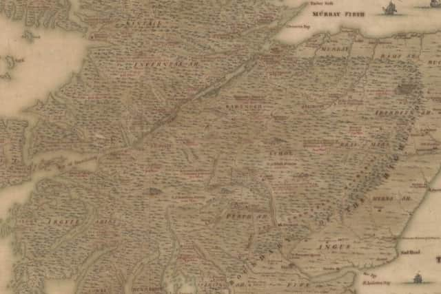
The map, created in 1731 by Jersey-born artist Clemant Lempriere, features in the National Library of Scotland’s (NLS) map archive.
It depicts Scotland at a critical period in history, during the intervening years between the Jacobite rebellions of 1715 and 1745.
Advertisement
Hide AdAdvertisement
Hide AdThe Hanoverian government of Britain had to contend with a very real and hostile threat emanating from the Scottish Highlands and islands in the form of Jacobitism.
The Jacobites were the supporters of Catholic King James VII (of Scotland) and II (of England) and his heirs. They sought to restore the Stuart dynasty to the throne after it was replaced by the Protestant House of Hanover.
The illustration not only provides an informed insight into Scotland’s past, but paints an image of the country as riotous, dangerous and divided.

“By 1731, the threat and reality of a Jacobite rebellion in Scotland led to a significant militarisation of the country by government forces” said NLS map curator Chris Fleet.
“That said, Jacobite support extended right the way to Wales and South-West England.”
Some Highland chieftains viewed Jacobitism as a means of resisting hostile government intrusion into their territories.
As the only part of Britain which still maintained private armies, in the form of clan levies, the Highlands still posed a threat to the British establishment.
Advertisement
Hide AdAdvertisement
Hide AdFleet explains: “The Board of Orders, a department of the British government that maintained both civil and military wings, was therefore presented with an image of the highlands and lowlands pitted against each other.”
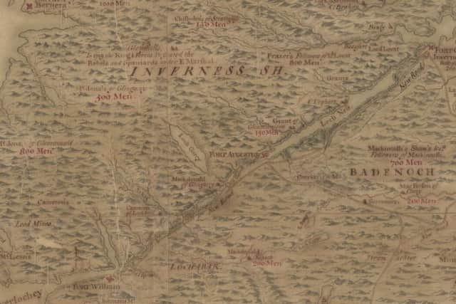
Each name which appears on the document refers to the main chief of a specific clan, whilst the figure below indicates the number of men in each clan.
In top right hand corner of the document a tally of men can be seen, the clans who were believed to be loyal to the Jacobite cause are coloured red with their number totalling 13,310.
The manuscript also illustrates a number of the roads that were newly extended across the border.
General George Wade, who was commissioned by King George I to report on the growing threat of the Highland insurrection in 1724 was responsible for founding and constructing new infrastructure that features in the map.
These include two new forts, Fort George (Inverness) and Fort Augustus, as well as constructing 40 bridges and over 250 miles of roads between these forts particularly along the Great Glen and from Dunkeld and Crieff to Fort Augustus and Inverness.
A number of ‘Wade roads’ appear on the map, such as the road running from Perth to Inverness, which today is the A9.
Advertisement
Hide AdAdvertisement
Hide AdEventually the last Jacobite rebellion of 1745 was crushed following their devastating defeat at the Battle of Culloden in 1746.
The government then began to suppress the culture and traditions of the proud Highlanders by disarming their warriors and forbidding the wearing of kilts and tartan.
DOWNLOAD THE SCOTSMAN APP ON ITUNES OR GOOGLE PLAY