Areas of Glasgow lost to the M8


Whether it was for the greater good or not, the motorway ripped the heart out of inner city Glasgow. It obliterated buildings and extinguished long-established communities, forcing friends, neighbours and relatives to spread out far and wide.
The once heavily-populated areas of Townhead, Cowcaddens, Charing Cross, Anderston and Kinning Park would never be the same again.
Townhead
Advertisement
Hide AdAdvertisement
Hide AdTaking in historic landmarks such as Glasgow Cathedral and Provand’s Lordship, Townhead is one of the oldest parts of the city.
By the early 1900s, it had developed into a densely-populated, close-knit community, but, like many other working class areas of the day, it struggled with high levels of poverty and deprivation.
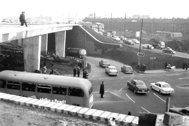
In 1962 the decision was taken to make Townhead a Comprehensive Development Area to allow for the construction of the M8 and the expansion of Strathclyde University. A great number of streets, and ancient road layouts, including the legendary kilometre-long Parliamentary Road, vanished in the process.
Within just a decade of the CDA declaration, an area once teeming with young working families and vital industry had been replaced with a construction site and a massive motorway interchange.
The population of Townhead by the end of the 20th century was around 8,000, less than half the number of people who had lived there a generation before.

Cowcaddens
Cowcaddens began life as a village to the north west of the old centre of Glasgow. The district grew following the construction of the Monklands Canal, leading to it being amalgamated with Glasgow in 1846. As the 20th century approached, the vast majority of residents in the area were living in insanitary, overcrowded tenements, and Cowcaddens became infamous for its low life expectancy and high child mortality. This reputation for poor living conditions continued well into the 1900s and contributed heavily to the area’s existing layout and architecture being wiped off the map.
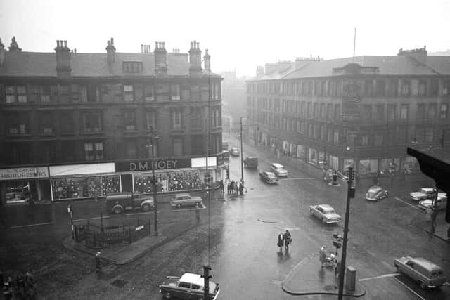
Designated a Comprehensive Development Area in the 1960s, very few of Cowcaddens’ original tenements now survive. Also demolished was Buchanan Street Railway Station, which, along with St Enoch to the south, was considered surplus to requirements in the wake of the Beeching Report. The area today is a mish-mash of commercial developments, high rise housing, busy roads and underpasses, with the M8 providing a distinct barrier to the north. Buildings such as the neoclassical National Piping Centre on McPhater Street provide a subtle hint of what existed here before.
Charing Cross
Advertisement
Hide AdAdvertisement
Hide AdFor many Glaswegians, the destruction of old Charing Cross for the M8 was an unforgivable act of urban vandalism.
Providing a link between Sauchiehall Street and Glasgow’s upmarket West End, the formerly bustling crossroads once boasted some of the finest architecture in the city. This is evidenced by the few buildings from old Charing Cross which still remain; J.J. Burnet’s exquisite Charing Cross Mansions and the Edwardian Baroque Mitchell Library towards Anderston being perfect examples.
Just west of Charing Cross Mansions was the Grand Hotel, a stunning Victorian edifice which provided the base for many a Glasgow wedding reception during its lifespan. Despite the best efforts of student activists and heritage campaigners, the Grand Hotel and hundreds of other widely-admired buildings were pulled down in the late ‘60s.
Today, the M8 cuts a deep canyon through the heart of Charing Cross, continuing north towards another barely-recognisable old junction, St George’s Cross.
However, a new proposal to build a roof park over the M8 at Charing Cross could see it transformed into a pedestrian-friendly district once again. Speaking of the plans, which were announced this week, one design firm said it would “heal the wound” caused by the motorway.
Anderston
Situated south of Charing Cross is Anderston, on the north shore of the Clyde. The old Anderston was positively flattened for the M8. Scores of high-density tenement-laden streets, including the ancient five-way-junction at Anderston Cross, were ruthlessly swept away for what was originally intended to be the western flank of the Inner Ring Road. A side by side comparison of old Anderston and how it looks today can be quite startling as the developers left barely a building standing.
Known for generations as a tight-knit community, Anderston in the immediate post-war period was described as a “large village” within Glasgow’s inner city. Locals knew one another and had little need to venture out of the district for everything they needed was right on their doorstep.
Advertisement
Hide AdAdvertisement
Hide AdHowever, with many of its dilapidated Victorian properties suffering from overcrowding and poor sanitation, Anderston was an easy target for the developers. Once it was agreed to build the motorway, the area began to rapidly disappear.
In 1950 Anderston had 32,000 residents, but within just 20 years more than two thirds of them had been relocated to new ‘villages in the sky’; the high rise blocks which were being constructed on the outskirts of the city and beyond.
A comprehensive redevelopment plan saw the creation of the Anderston Centre complex in the 1960s, an ambitious, Le Corbusier-esque residential-commercial project which would never be fully-realised.
The new Anderston of glass office blocks and concrete high rises shares very little common with the thriving industrial/residential district it replaced. The former Bilsland Bakery, an Anderston landmark for over a century, was torn down in 2015 as part of the third phase of the Central Quay Development.
Kinning Park
Hemmed between the Glasgow-Paisley railway and the busy docks on the south shore of the Clyde, Kinning Park was once a thriving industrial hub with a large tenement-dwelling residential population.
In the 1970s the district was cut in two by the motorway’s western approach towards Tradeston. Swathes of Kinning Park’s four-storey sandstone tenements gradually disappeared, with residents shipped out to far flung outskirts.
Situated close to Kinning Park tube station, the long-since flattened MacLellan Street was a Glasgow curiosity and a postman’s worst nightmare. The north side of the street once boasted a continuous row of tenements, half a kilometre long; an unbroken link of 49 individual buildings, making it the longest row of tenements in Glasgow.
Much of old MacLellan Street is now buried beneath 8 lanes of motorway where the M8 meets the M77.