Luftwaffe aerial photos from skies over Scotland head under the hammer

But their purpose was altogether nefarious, and on closer inspection, many contain a dreadful truth in their detail.
Now, a vast collection of rare reconnaissance photographs taken by the Luftwaffe from the skies above Britain is to be sold at auction.
Advertisement
Hide AdAdvertisement
Hide AdThe striking pictures formed part of an exhaustive catalogue amassed by the Germans in the years leading up to World War II, and during the conflict itself.
One startling image even captures the moment German bombers launched their first air raid on Britain during World War II, targeting the might of the Royal Navy in the Firth of Forth.
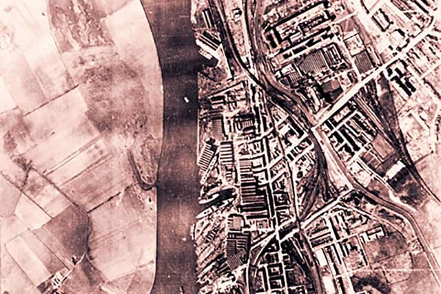
Particular attention was paid to Scotland’s heavy industrial heartlands, which would later be targeted by a series of devastating air raids.
The photographs have been painstakingly collected over the years by the author, Nigel Clarke, who said the Germans were “deeply attuned” to Scotland’s strategic significance during the war.
“They were taking photos all over, looking at features, ports, harbours, principal buildings, and power stations,” he said. “The only problem was that Scotland was outside the bombing range for a lot of the flights. It was a long journey from the Luftwaffe bases.”
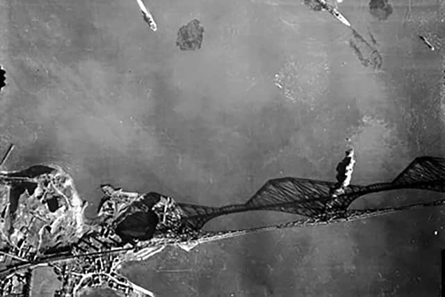

One of the photographs heading for auction later this month depicts the Battle of the River Forth, when nine German bombers reached the extreme limit of their range as they closed in on Rosyth naval base.
The raid, which took place just six weeks into the war, caught the British air defences by surprise, with no alarms sounded, and anti air-raid gunners on the Forth engaged in a drill at the time.
They quickly swapped their dummy ammunition for live rounds, but could not prevent the Germans landing a heavy blow, with 16 Royal Navy crew killed and a further 44 wounded.

Advertisement
Hide AdAdvertisement
Hide AdThe Luftwaffe image shows the attack by Junker Ju 88s, as they targeted the destroyer HMS Southampton, as well as the cruisers, HMS Edinburgh and HMS Mohawk.
What looks like strange, dark clouds in the water is actually vast mud plumes rising to the surface as wayward German bombs made impact with the seabed.
“The RAF eventually chased them off and shot some of the bombers down, but some of the ships sustained damage,” said Mr Clarke. “It’s significant because it’s the first aerial bombing of Britain in the war.”
The Germans began taking reconnaissance photographs of England in 1936, with the first images of Scotland dating to 1938. At first, they used concealed cameras mounted in civilian Lufthansa aircraft, but after war broke out, the Luftwaffe’s operation was rapidly upscaled.
By the end of the 1939, there were 23 long range reconnaissance units, whose work had helped piece together a photographic mosaic of the British Isles.
“The German High Command had realised early in the war the importance of up-to-date aerial intelligence,” says Mr Clarke, whose book, Adolf’s British Holiday Snaps, explores the extent and importance of the reconnaissance work.
“The German army had developed the quick blitzkrieg attack. This involved the rapid invasion of hostile countries using vast numbers of men and equipment. For the attack to work there was a need for accurate mapping and reconnaissance of landscapes.”
For decades, the Luftwaffe photographs were hidden from view. Each unit had its own laboratory, where film was developed, analysed using stereoscopic viewers, printed, and then distributed. The images were collated at a central intelligence archive at Zossen, south east of Berlin.
Advertisement
Hide AdAdvertisement
Hide AdWhile that archive was destroyed in the closing months of the war, many photographs were also kept at German airfields and military installations. The Allies eagerly gathered all they could find, with the records eventually shipped to Washington DC in the 1950s. There, they were classified as top secret until the 1970s.
David Wackett, a senior valuer and auctioneer at Ewbank’s, the Surrey-based auction house which will sell the photographs, said they remained a valuable resource in the lead up to the Cold War.
“At the end of the war, the Luftwaffe aerial photographs were eagerly collected by the Soviet, American and British intelligence services,” he explained.
“With the approaching Cold War both sides were eager to gather all available information on each other’s economic capability.”
Mr Clarke first became aware of the archive in Washington after it was declassified, with the advent of satellite imagery rendering them a curiosity.
He hoped the images would help him better understand coastal and cliff erosion in his home county of Dorset, but quickly realised their historical significance.
Over the years, he gradually built up the collection, and received a cache of images from a man whose father had been a staff sergeant to war hero Lieutenant General Sir Brian Horrocks.
In all, his archive spans 520 contact negatives, as well as original target and operation portfolio material handed to Luftwaffe pilots, and German extracts of ordnance survey maps.
Advertisement
Hide AdAdvertisement
Hide AdWhile the military importance of the collection is obvious, Mr Clarke also says it offers a rare glimpse of a bygone Britain.
”This was the first ever comprehensive aerial survey of the UK – we didn’t carry one out until 1947. We didn’t think that reconnaissance was gentlemanly,” he said. “By then, places like Govan in Glasgow, and Bristol and Coventry had all been bombed and had changed dramatically.”
“The changes to the landscape are the most important thing in my view. When those photos were taken, the average size of a farm was only 30 acres, and they only had around 10 cows, which sounds ludicrous now.”
Mr Clarke’s photographs will be sold by Ewbank’s on 24 June.
Comments
Want to join the conversation? Please or to comment on this article.