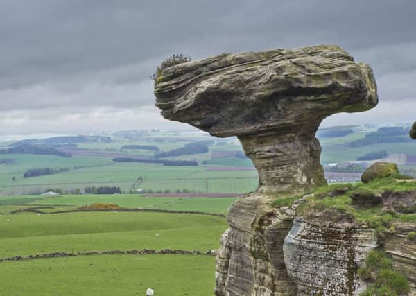
Walk of the week: West Lomond and the Bunnet Stane


On a cold, grey February day of considerable wind chill, Jimbo, John, Alan and I, all clad as if bound for the high tops, had a short Lomond outing – a new-for-me approach to West Lomond, passing the Bunnet Stane, then a return by Glen Vale. It was an interesting drive to the mapped car park by the minor road at the foot of Glen Vale, map ref 172069.
We encountered lots of pot holes gouged by heavy rain and floods making the road more like a rough farm track. However, council workers were undertaking the necessary ditching improvements, preparatory to attending to the road surface.
THE ROUTE
Advertisement
Hide AdAdvertisement
Hide AdWalk north-east along the road for one mile to reach the start of the mapped path, map ref 185082 (and another car park, smaller and not mapped), just before Nether Urquhart farm. The path heads south-east as if direct to the summit, and on gaining height to some 200m the way smacks of an old narrow road between low dykes. Straight ahead is an intermittent rocky horizontal line; strange outcrops of calciferous sandstone that have resisted erosion.
On top of the largest outcrop, and looking like a mighty mushroom, is the unmapped Bunnet Stane, measuring 20ft by 10ft and nearly a metre thick. Climbing to the base of the bonnet is easy enough, but none of us was tempted to climb any further. Tucked away to one side behind a metal cage is a small man-made chamber, the Maiden Bower, around which has been cast a story of a tragic Romeo and Juliet style romance. The less romantic truth is that the bower may have been some sort of bothy built by a landowner, probably in the early 1800s.
The path of old climbs and slants to the left to meet a grassy track which heads right over the summit cone and so to the remains of an Iron Age fort, the trig point and its eroded base.
A quick descent and tussocky traverse leads towards Glen Vale, the gap between West Lomond and Bishop Hill, also known as Covenanters Glen. We bypassed the Devil’s Burdens, heading for the rocky bluff which overlooks the glen. A careful descent, easier to the east at first, leads to the Glen Burn. Cross the burn and climb to the higher track on the south bank from where the rocky bluff is best viewed. The crag, or rather a cleft in the rocks, is the “pulpit” from which John Knox preached, and the point at the top end of the secluded glen where local people, who believed in the reformation, would congregate secretly. However, for safety reasons the rocks which formed the pulpit were removed in 2004.
Follow the track west a short distance, then slant down as signed, cross the burn and rejoin the north bank path. Lower down, the glen gradually widens. The path continues through a recently planted area, re-crosses the burn by a wooden footbridge and continues through a wooded strip. Turn right on reaching the road to return to the car park.
After refreshment at the RSPB Vane Farm cafeteria my outing came to a premature stop. Car trouble! Following conversation with the driver of the breakdown vehicle on the way to the garage, I now know more about crankshafts, power steering and alternators. I then got a bus. Alas, it too broke down, leaving me with another two miles to walk. It had been an interesting day and 4 hours longer than expected to return home.
Map Ordnance Survey map 58, Perth & Alloa
Distance 5 miles
Height 400m
Terrain Minor road, paths and grassy slopes
Start point Mapped car park by minor road at foot of Glen Vale, map ref 172069.
Time 3 to 4 hours
Nearest town Kinross
Refreshment spot RSPB Vane Farm cafeteria