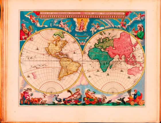
Roger Cox: Publishing arms race that led to 'world's most beautiful atlas'


It’s difficult for the modern mind to grasp quite how miraculous this atlas must have seemed in its day. After all, buying an atlas is now the matter of a few clicks of a mouse, if indeed anyone still feels the need for a paper atlas at all any more, when we’re free to go swooping around a virtual planet Earth whenever we feel like it, thanks to the magic of Google Maps. Still, the vital statistics of the Blaeu atlas are jaw-dropping: printed in 11 volumes, it consists of 3,368 pages of Latin text and some 594 maps. The typesetting alone, it has been calculated, would have taken the equivalent of seven man-years, assuming a ten-hour working day and a time of 440 minutes per page. A coloured version of the atlas sold for 450 guilders – roughly what it would have cost to rent a farm for a year – making it the most expensive book money could buy.
Blaeu went to all this trouble because he was locked in fierce competition with the rival Honduis-Janssonius map-making dynasty. He who could produce the most extensive atlases, and present them in the most luxurious bindings with the most attractive typography and colouring, would shift the most units, and so a sort of publishing arms race ensued, reaching its apogee with the Blaeu Atlas Maior.
Advertisement
Hide AdAdvertisement
Hide AdAnd, for their time, these atlases were cutting edge, too, following the development of a groundbreaking new projection method by Flemish cartographer Gerardus Mercator.
Mercator’s name is probably the best-known in the history of cartography, yet explaining what he achieved can be a slippery business. Perhaps the clearest account of his eureka moment, certainly for the geometrically-challenged, appears in double-Pulitzer winner John Noble Wilford’s book, The Mapmakers – recently re-released in an attractive new edition by the Folio Society. As Wilford puts it, “Like Ptolemy long before him, Mercator attempted with his projection to achieve a common-sense answer to an insoluble problem: how to translate the sphere that is the Earth with relative accuracy into the flatness of a map.”
Mercator’s breakthrough was his world map of 1569, and the key was the projection he’d used – that is, the way he’d chosen to represent the curved surface of the earth on a flat plane. According to Wilford, Mercator never explained how or why he arrived at the solution he did, but it has been suggested that, while transferring the features of a globe onto paper, he might simply have wondered what would happen if the lines of longitude were “portrayed as straight lines perpendicular to the equator – not lines converging, as they do, towards the poles.” As Wilford goes on to explain, Mercator realised that in order for this system to work, “it would be necessary for the spacings of the parallels of latitude to be made progressively larger away from the equator towards the poles” – so at the equator the projection is accurate, whereas towards the poles, landmasses appear larger than they really are. Still, in spite of this glitch, Mercator had succeeded in producing a map on which navigators could finally plot straight-line courses from one place to another – a major advance.
Mercator brought out his own world atlas in 1595, to great acclaim, then Jodocus Honduis purchased Mercator’s copper plates in the early 17th century, allowing him to start building up the Honduis mapmaking empire, and it was Blaeu’s purchase of a set of Mercator plates from Jodocus Honduis the Younger in the 1620s that allowed him to set up in competition. Blaeu’s Atlas Maior, then, was an object of great beauty, but, thanks to Mercator, it also presented a picture of the world to its wealthy owners that we would recognise today. n
You Are Here is at the National Library of Scotland, Edinburgh until April 2017, www.nls.uk/exhibitions; The Mapmakers by John Noble Wilford is published by the Folio Society, www.foliosociety.com