'˜Stadtplan von Edinburgh' '“ the Nazi war map of Scotland's capital


Published in 1941, the Stadtplan von Edinburgh is a comprehensive German bombing map detailing the capital’s places of military, geographic and strategic significance.
The unsettling document serves as a timely reminder that Edinburgh, like everywhere else in Britain at this time, was under real threat from Hitler’s forces.
Advertisement
Hide AdAdvertisement
Hide Ad
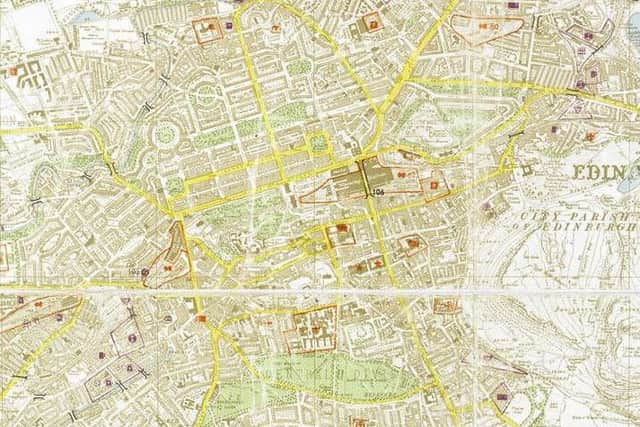
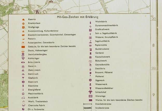
The map was created by adapting existing British Ordnance Survey (OS) maps. Military data was compiled by the German Army Division for war maps and surveying, and then overlaid on to the OS map. A colour-coding system, supplemented by a concise legend made it easy for the Luftwaffe to identify potential aerial bombardment targets.
Edinburgh’s transportation hubs, medical institutions, places of worship and interest are marked out in red, while purple indicated the presence of manufacturing facilities. The city’s numerous bridges are outlined in bold
Not surprisingly, the docklands of Leith appear to be of particular interest. The port suffered disproportionately compared to the rest of Edinburgh.
Edinburgh survived World War Two relatively unscathed. The Luftwaffe conducted 18 bombing raids on the capital, inflicting a total of 20 civilian casualties and 210 injuries. Edinburgh civilian deaths during WWII account for less than 1% of the number of civilians killed in Scotland as a whole.
Interestingly, the origins of modern Ordnance Survey maps can be traced back to the aftermath of the 1745 Jacobite rising, when Scotland’s wilderness and vast mountain regions were mapped out for military ordnance (artillery) purposes.