New hi-tech survey to uncover secrets of Culloden battle


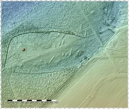
A team of experts working for the conservation charity National Trust for Scotland (NTS) have used a pulsed laser beam fired from a plane to provide detailed surveys of the battlefield at Culloden Moor, where the final confrontation of the Jacobite rising took place on 16 April 1746.
Between 1,500 and 2,000 supporters of Charles Edward Stuart, mainly Highlanders, were killed or wounded in the brief but bloody clash with Hanoverian loyalist troops led by the Duke of Cumberland. Government losses were lighter, with around 50 dead and a further 260 wounded. The team is hoping the surveys will unearth previously undiscovered remains and offer new information.
Advertisement
Hide AdAdvertisement
Hide AdStefan Sagrott, archaeological data officer for NTS said the technology is “revolutionising” the way archaeological work is carried out.
“Because we can view and light the digital model from different angles, it can pull out topographical features that we wouldn’t see in any other way,” he said.
“It’s providing us with a view of the Culloden battlefield that we’ve never had before, and that’s really exciting.”
Known as LiDAR, which stands for Light Detection and Ranging, the laser scanning technique measures thousands of points per second to build up a detailed model of the ground and its features.
“We can filter the LiDAR data to remove some of the vegetation, such as tree cover, and this might allow us to find archaeological remains which are currently hidden within the tree cover,” he said.
Having such a detailed topographical survey of the battlefield means the researchers can also use digital mapping tools to analyse the positions fighters held and establish whether the local terrain played a part in how the encounter played out.
As well as offering new understanding of the famous battlefield, the surveys may shed new light on other sites.
Advertisement
Hide AdAdvertisement
Hide AdMr Sagrott added: “The area has a lot of prehistoric remains, such as the Clava Cairns just to the south of the Culloden, and these have been captured by the LiDAR survey as well, so we’ll be using the data to visualise these and look at other archaeological sites in the area.”