Google Earth update shows devastation in Ukraine’s Mariupol after Russia’s bombing

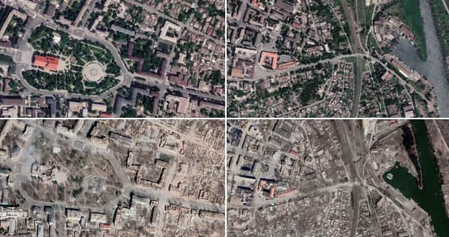
Updated images on Google Earth reveal the true devastation of the Ukrainian city of Mariupol since the Russian invasion. Satellite imagery shows the once flourishing city turned into a wasteland, with landmark buildings reduced to rubble.
The eastern city, which was one of the first cities to fall under Russian control, is still under occupation, and has frequently made headlines as the stage for some of the most brutal fighting since the war began.
Advertisement
Hide AdAdvertisement
Hide AdIn March last year, news of an airstrike on the Donetsk Regional Drama Theatre, which was used as a shelter by more than a thousand civilians, shocked the world. It was estimated the attack killed at least 300 people, including children.
The former mayor of the city, Vadym Boychenko, has claimed more than 20,000 residents have been killed there since fighting began. He has also accused Moscow of hiding bodies in mass graves to cover up the numbers.

Russian president Vladimir Putin visited Mariupol shortly after the International Criminal Court (ICC) issued a warrant for his arrest for alleged war crimes. In the clips, seeingly cheerful Ukrainians welcomed the leader, with one voice heard in the background shouting: “It’s all lies, it’s all just for show”.
Comments
Want to join the conversation? Please or to comment on this article.