Weather: Met Office issues yellow warnings for snow and ice in Scotland


The first warning is in place from 10pm on Monday, February, 1, and will remain until 11.59pm on Tuesday, February, 2.
Advertisement
Hide AdAdvertisement
Hide AdThe warning stretches up to Aviemore in the north and continues south into England.
Snow, with a risk of widespread ice, is expected to push gradually north-east during the day on Tuesday, and forecasters have warned that it is likely to bring difficult travel conditions.
A statement on the Met Office website says: “A band of rain, locally heavy in places, is likely to push slowly north-east across parts of the UK.
"As this rain comes into contact with cold air in place, it is likely to readily turn to snow away from eastern coastal districts."
Forecasters warn that a period of freezing rain is possible which could result in widespread icy stretches.
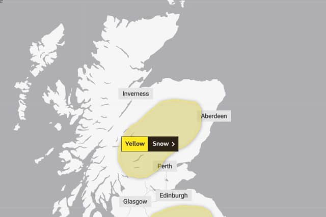
The second warning is in place from 00.00am until 11.59pm on Wednesday, February, 3, and predicts heavy snow in central mainland Scotland.
The Met Office has warned that it could lead to travel disruptions.
A statement on the website says: “Snow is most likely to fall on higher ground, mainly above 200 to 300 metres. Significant accumulations of 10 to 20 cm are possible, perhaps as much as 40 cm across the Grampians.
Advertisement
Hide AdAdvertisement
Hide Ad"This amount of snow could bring disruption to travel across trans-Pennines routes and the higher roads across the Southern Uplands and Grampians.”
A message from the Editor:Thank you for reading this article. We're more reliant on your support than ever as the shift in consumer habits brought about by coronavirus impacts our advertisers.
If you haven't already, please consider supporting our trusted, fact-checked journalism by taking out a digital subscription.
Comments
Want to join the conversation? Please or to comment on this article.