Storm Ali: Met Office weather warnings explained


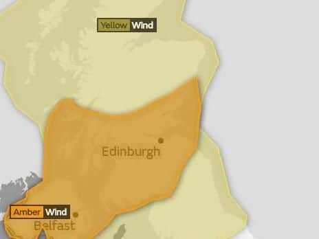
The storm is the first of the 2018-19 UK season and an amber "be prepared" warning for wind has been issued. Regions covered by this warning include Edinburgh, the Lothians and Borders, Strathclyde, the south west, Argyll and Bute, Tayside, Fife and Grampian.
Met Office spokeswoman Bonnie Diamond says that gusts of between 65mph and 75mph will hit low-lying areas, while gusts of 85mph could be felt on higher ground.
Advertisement
Hide AdAdvertisement
Hide AdThe Met Office website now says that "flying debris is likely and could lead to injuries or danger to life."
Planes, trains and ferries will likely be affected, while bridges may also be shut off to some traffic and there may also be power cuts.
What the weather warning colours actually mean
Yellow: Severe weather expected. Yellow means you should plan ahead thinking about possible travel delays, or the disruption of your day-to-day activities.
Amber: Be prepared for disruption. There is an increased likelihood of bad weather affecting you, which could potentially disrupt your plans and possibly cause travel delays, road and rail closures, interruption to power and the potential risk to life and property.
Red: Extreme weather is expected. Red means you should take action now to keep yourself and others safe from the impact of the weather. Widespread damage, travel and power disruption and risk to life is likely. You must avoid dangerous areas and follow the advice of the emergency services and local authorities.
Why the Met Office names storms
The Met Office decides to name storms when there is potential to cause an amber "be prepared" or red "take action" warning.
The colour codes are based on the Met Office 'national severe weather warning service,' which is a combination of both the impact the weather may have and the likelihood of those impacts happening.