Scotland’s weather: Amber warning of heavy rain and flooding with ‘significant impacts’

The Scottish Environment Protection Agency (Sepa) said parts of Dumfries and Galloway and the Borders could experience “significant impacts” as it issued 11 flood warnings for Friday. They include for Dumfries, Langholm, Hawick, Peebles and Pollok Park in Glasgow.
Police Scotland warned travellers to consider delaying setting out until conditions improved and said road closures and delays were likely.
Advertisement
Hide AdAdvertisement
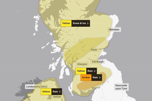
Hide AdThe Met Office has also announced a yellow – less severe – warning for snow and ice across the Highlands on Friday, with “significant accumulations” on higher ground. A previously-announced yellow warning for rain that covers central and southern Scotland has also been extended.
Further downpours are expected for Hogmanay on Saturday.
The amber warning for rain will be in force from 3am to noon on Friday, covering much of Dumfries and Galloway and the Borders from Wigtown to near Jedburgh, including Dumfries.
A Met Office spokesperson said: “Rain will become heavy and persistent overnight into Friday morning. Accumulations of 40-50mm are expected quite widely with 60-70mm possible in a few upland locations.
"Following recent wet weather, river and surface water flooding is likely. The rain will clear to the east by the end of the morning.”

The yellow warning for snow and ice across the Highlands, Lewis and Harris will be in force from midnight to 9pm on Friday.
The Met Office said: “Outbreaks of rain will readily turn to snow as it encounters cold air over Scotland. Snowfall will be temporary at low levels but will be more persistent over high ground where some significant accumulations will occur.
“5-10cm is expected to accumulate widely above 200m, with as much as 20cm possible above 400m. Ice will be an additional hazard where snow compacts or refreezes.
"To the south east of Inverness to Fort William, the snow will slowly turn to rain from the south during Friday morning.”
Advertisement
Hide AdAdvertisement
Hide AdThe agency said its separate yellow warning for central and southern Scotland had been expanded to include Dundee and Angus and more of the Scottish Borders, with the likelihood of medium impacts being increased.
The start time has also been brought forward from 3am on Friday to midnight, but the alert is now due to end earlier, at 2pm rather than 6pm.
The alert for this area stated: “Heavy rain will arrive in the early hours of Friday morning, lasting throughout before clearing from the west. 20-30mm will fall widely within a 12 hour period with 50-70mm possible in a few areas, mainly across high ground in the south.
"The rain will be preceded by a spell of snow over higher ground, particularly to the north of the Central Belt. Strong southerly winds will accompany the rain, especially around south western coasts, where gusts of 55-65mph are likely.”
Sepa said up to 12 hours of prolonged, sometimes heavy rain from midnight on Thursday was expected to cause river levels to rise with a risk of flooding.
Meantime, the A83 at the notorious Argyll landslide hotspot at the Rest and Be Thankful will be closed from 4pm on Thursday because of the forecast further heavy rain on the already saturated hillside.
Traffic will be diverted onto the parallel single-track Old Military Road through Glen Croe until at least Friday morning.
Until 4pm on Thursday, vehicles will be accompanied by patrol vehicles in convoys through the at-risk section of the A83, which is already protected by debris catch pits and fences.
Advertisement
Hide AdAdvertisement
Hide AdA spokesperson for BEAR Scotland, which maintains the trunk road to Kintyre for Transport Scotland, said: “Given the forecast for heavy persistent rainfall overnight, and the high hillside saturation being experienced because of recent weather, traffic will then be diverted onto the Old Military Road local diversion route.”
The Met Office said the wet and windy weather was being pushed on by a strong jet stream – the driving force behind much of the weather the UK experiences.
It explained: “Although the cold weather in North America isn’t directly impacting the UK’s weather, the temperature contrast across the Atlantic is strengthening the jet stream, leading to a succession of low-pressure systems impacting the UK in the coming days."
Deputy Chief Meteorologist Helen Caughey said: “It’ll be an unsettled New Year weekend for much of the UK, with frequent and at times heavy rain, and a chance this could turn to snow mainly across high ground in Scotland, although there remains a lot of uncertainty where the boundary between the milder and colder air will be.
“New Year’s Eve will be the wetter of the two days, with a number of fronts bringing rain to many areas, especially parts Scotland as well as south and south-west England, where there will also be some very strong winds along the English Channel.
"What that leaves behind is an unsettled New Year’s Day, with central and southern parts of the UK likely to see further showers and some longer spells of rain. Further north things are a little more uncertain, but generally a mix of sunshine and showers here, mainly in the east, before conditions look likely to become more widely settled into Monday.”
The unsettled weather is expected to continue in Scotland next week, with showers, some longer spells of rain and strong winds.
Comments
Want to join the conversation? Please or to comment on this article.