Scotland Weather: More disruption for Scots with snow and ice on the way


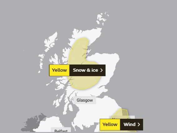
Yellow snow and ice warnings have been put in place across much of the central highlands covering Angus, Perth and Kinross and Stirling, as well as Aberdeenshire, Moray and the central Highlands, with the Met Office stating that it is likely parts of Argyll and Bute will also be affected.
Expected to last from early on Tuesday morning through until around 1pm in the afternoon, people are being warned to expect icy patches and wintry showers which may lead to further travel disruption.
Advertisement
Hide AdAdvertisement
Hide AdThe news follows the arrival of storm Brendan, which saw much of the country battered with 60-70 mph winds over the weekend causing ferry services along the coast of Scotland, including services from Oban, Skye, Iona and Tiree, to be cancelled or severely disrupted and all schools on the Western Isles to be closed.
Named by Met Eireann, the national meteorological service in Ireland, the powerful storm brought high winds and heavy rain to the west coast of Scotland on Monday, with road, rail and air travel also affected, and The Scottish Environment Protection Agency (Sepa) issuing flood warnings for many parts of the country.
The warnings come as last month was confirmed as providing the warmest December temperature ever seen in the UK.
The mercury soared to 18.7C (65F) at Achfary in the Highlands on December 28, smashing the existing record which had stood since 1948.
Since the New Year, however, a 230mph Jetstream has been firing a series of low-pressure systems across the Atlantic.
At the weekend, Met Office forecaster Bonnie Diamond explained that after a fairly quiet December, the country is now entering a "more active period of weather", she said: “It’s just one low-pressure system after another and I would not be surprised if there are more warnings for Tuesday night into Wednesday.
“In any case, there’s wind, rain and more snow to come for Scotland.”
Speaking about the latest warnings, a spokesperson for the Met Office added: "Icy patches are likely to develop on Monday night and into Tuesday morning as blustery showers fall on cold surfaces, especially untreated roads and pavements.
Advertisement
Hide AdAdvertisement
Hide Ad"In addition, above 200 metres elevation, showers will fall as snow at times and above 400 metres there will be occasional heavy snow showers, bringing perhaps 2 to 6 cm, as well as temporary blizzard conditions. Snow showers will become confined northwest of the Great Glen by the end of the morning."