Storm Diana set to blast Scotland and disrupt travel across nation
Yellow weather warnings for heavy rain and high winds have been issued for Scotland.
A spell of windy weather is expected to affect western parts of Scotland between 9am and Midnight on Wednesday 28 November, making delays to public transport likely, journey times almost certainly longer, and delays for high-sided vehicles on exposed routes and bridges also a high possibility.
Advertisement
Hide AdAdvertisement
Hide Ad
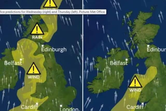

In addition, high winds are expected to affect the far northeast of the country between Noon on Wednesday 28th and the early hours of Thursday morning.
Some delays to road, rail, air and ferry transport are expected, along with delays for high-sided vehicles on exposed routes and bridges.
When it comes to rain, heavy downpours are expected in northeastern Scotland on Wednesday between Noon and 11pm at night, which may lead to travel disruption and flooding in some places - with water on the roads probably making journey times longer.
Richard Miles, a Met Office spokesperson, said: "Commuters should take extra care ahead of tomorrow's conditions, particularly in coastal and exposed areas.

"Account for the conditions and build it into your journey time to make up for delays."
Causing chaos?
Areas affected by the wind warnings are Central, Grampian, Tayside & Fife, Highlands & Eilean Siar, Orkney & Shetland, South-West Scotland, Lothian Borders and Strathclyde.
Areas affected by the rain warning are Central, Tayside & Fife and Grampian.

Edinburgh can expect cloudy and windy conditions with gusts of 50 to 60mph, possibly 70mph in more exposed areas.
Advertisement
Hide AdAdvertisement
Hide AdThe Scottish Environment Protection Agency said officials are monitoring the situation over fears that heavy rain could add to snow melt, sparking flooding.
High-speed winds have previously caused chaos on the roads, especially on major bridges where crossing is deemed unsafe.
At the weekend, ferry operator Caledonian MacBrayne placed passengers on standby for delays and cancellations on many west coast routes as early as Tuesday (26 November). The company said it had received a forecast of winds hitting 61mph.
Strong winds and heavy rain
Storm Diana is currently threatening the Azores and is due to make itself felt over western parts of the UK soon.
Conditions are expected to start turning today.
Gales of up to 60mph could be seen over western parts of the UK, along with rain totals of between 60mm and 80mm in some western parts over the coming two days.
Forecaster Nicky Maxey said: "Gusts of 60mph can be anticipated, with 70mph possible in more exposed locations.
"Strong winds and heavy rain will continue to affect Scotland on Thursday morning, as this low pressure system passes over northern Scotland. It will remain blustery on Friday morning."