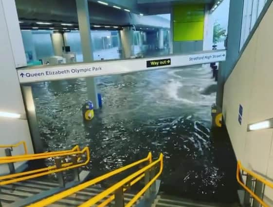
London flooding: Roads and Tube stations flooded as thunderstorms strike south of England


A London resident said flooding in the city was the worst he had seen in his lifetime, while water gushing from an Underground station was caught on video.
Londoner Eddie Elliott cycled past the area outside Queenstown Road station, where he said the road had been “totally shut down”.
Advertisement
Hide AdAdvertisement
Hide Ad“Having been born and raised in London, I have never seen anything quite like it,” the 28-year-old writer told PA.
“Stands out as the worst I’ve experienced personally… totally shut down the whole road with buses stood broken down in the water.”
Jamie Curtis said the roads near Clapham Common were blocked due to floodwater which was “12 to 18 inches deep”.
“(I’ve) not seen that level of flooding in London before,” he said.
The Met Office has issued an amber warning for storms covering London and some of the Home Counties where homes and businesses are at risk of flooding, lasting until 7pm on Sunday.
A yellow warning for storms which could cause travel and power disruption also covers a wider area of the south from Norwich to Plymouth, and lasts until midnight.
Met Office meteorologist Steven Keates said parts of the south between south Suffolk and the Isle of Wight could be deluged by 100mm of rain in just a few hours on Sunday evening.
“There’s torrential thunderstorms around yet again,” he said.
Advertisement
Hide AdAdvertisement
Hide Ad“Into the evening, from Norfolk to Bournemouth we are going to see some pretty lively showers.
“Torrential downpours, thunder and lightning and potentially some hailstones are settling in the south.”
Mr Keates said the storms are being caused by a “convergence” of air currents, due to warmth in the earth’s surface from the recent heatwave rising into cooler air in the atmosphere.
It comes after lightning set fire to houses in Andover, Hampshire, on Saturday morning, forcing residents to leave.
Neighbours heard an “enormous bang” as the strike set two homes ablaze on Mercia Avenue, and a 70-year-old woman was assessed by paramedics.
Kingston Police, who oversee a borough in the amber zone for storms, warned motorists to “drive carefully” and remember they are “not driving a submarine”.
The force said in a tweet: “Please remember to drive carefully.
“Also remember that you’re not driving a submarine.
“Do not enter what could possibly be deep water.
“Watch your speed and distance as stopping distances will be greater.”
Advertisement
Hide AdAdvertisement
Hide AdThe rain brought an end to the heatwave earlier this week, potentially disappointing anyone who hoped for a dry, sunny trip to the coast.
The rest of the country was forecast to experience a cloudy, more settled end to the week while sunshine is expected in Scotland.
Temperatures are set to rise in most places again on Monday as the storms clear, with the mercury predicted to reach 26C in London, 25C in Edinburgh, 24C in Cardiff, and 22C in Belfast.
The Met Office has predicted early cloud in some northern and eastern parts which will move up to Scotland, and sunny spells and scattered showers in most places throughout the day.
A message from the Editor:
Thank you for reading this article. We're more reliant on your support than ever as the shift in consumer habits brought about by Coronavirus impacts our advertisers.
If you haven't already, please consider supporting our trusted, fact-checked journalism by taking out a digital subscription.
Comments
Want to join the conversation? Please or to comment on this article.