Scotland weather: Met Office warns thundersnow and ice could cause disruption on Thursday and Friday
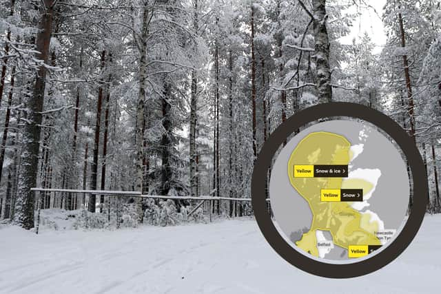
Thundersnow and ice is forecast to affect several areas, including the Highlands and Islands, Central, Tayside and Fife, south west Scotland, Lothian and Borders and all of Strathclyde, including Glasgow.

The first warning for snow will come into effect on 10am and will remain until 6pm on Thursday, January 6. A second warning for snow and ice will start at 8pm on Thursday, and will end at 11am on Friday.
Advertisement
Hide AdAdvertisement
Hide AdThe Met Office has warned that: “Frequent sleet, hail and snow showers may lead to some disruption to travel during Thursday night and Friday morning”.
Bus and rail services will likely be affected by the adverse weather.
Some areas may also experience a phenomenon known as ‘thundersnow’, which occurs when warm air from the south west is expected to collide with cold winds from the north.
On Thursday, the Met Office issued a separate warning of snow, which stretches from the Highlands, through Glasgow and Edinburgh, and into the north of England, and warned of disruption to roads.

It said many areas would see one to two hours of snow, with a risk of temporary slushy accumulations above 100-150m, with snow leading to difficult travel conditions.
Grahame Madge, spokesman at the Met Office, said: We have got an area of high pressure across the UK, that will remain in situ until the early hours of tomorrow morning. Then we will start to see the weather front coming in.
“As conditions get cold tonight, we’re seeing temperatures drop down to freezing quite widely. As we get the cold air, that will bring the temperatures right down, we’ve got the weather front coming in from the west and that moisture is going to bump into the cold air and where you get that you will get snow.”
The forecaster added that the prospect of thundersnow was driven by the same conditions which cause thunder in the summer, the difference in temperature between the ground and the air surrounding it.
Advertisement
Hide AdAdvertisement
Hide Ad“Because you have got that differential it’s possible, quite easily, for warm air at ground level when it heats up to start to rise very quickly up through the cold air and that’s what creates the potential for thunderstorms, so we are likely to see along with the other wintery showers, likely to see hail and snow,” he said.
Thundersnow is not meteorologically different to thunder in the summer, but rather than hail or rain there is snow which can affect the acoustics of the thunder, the forecaster said.
In the early hours of Thursday temperatures could feel as cold as -4C in Glasgow while in Edinburgh the Met Office has said commuters would face temperatures as low as -3C.
In Braemar, Aberdeenshire, the mercury could plunge to -8C in the early hours, and when the wind is taken into account it could feel as cold as -11C.
In Inverness, the northernmost city in the country, temperatures will feel as low as -4C and it will remain bitterly cold throughout Thursday.
In advance of the freezing temperatures, Traffic Scotland has urged people to drive with care because of the risk of ice.