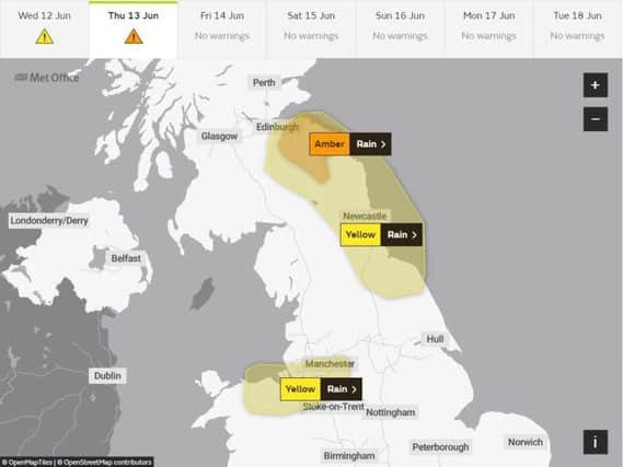
Scotland's weather: Amber warning for torrential rain


Major roads likely to be affected include the A1, A68 and A697.
Advertisement
Hide AdAdvertisement
Hide AdA lesser yellow - "be aware" - warning will cover the eastern half of Scotland south from Edinburgh, stretching as far south as North Yorkshire.
The Met Office said: "Heavy rain will develop during late Wednesday evening and the early hours of Thursday and then gradually start to ease later on Thursday morning.
"Thirty to 50mm is expected to fall quite widely, and over higher ground in south east Scotland 80 to 100mm rain is likely to fall over higher ground."
Flood alerts have been issued for Edinburgh, the Lothians and the Borders by the Scottish Environment Protection Agency (Sepa).
It said areas most at risk are East Lothian, Midlothian and the eastern Borders.
A flood alert means "flooding is possible - be prepared".
In Scotland, an outdoor Rod Stewart concert in Aberdeen was cancelled tonight "due to adverse weather conditions".
Rail users were hit by cancellations and delays as torrential rain struck Scotland, as well as England and Wales.
Sepa flood duty manager Marc Becker said: “Persistent and heavy rainfall is expected to head into south-east Scotland on Wednesday night continuing into Thursday morning resulting in a risk of surface water and river flooding impacts.
Advertisement
Hide AdAdvertisement
Hide Ad“The rainfall is expected to be heaviest over high ground in East Lothian and eastern areas of the Scottish Borders.
"This may result in travel disruption and flooding of properties and infrastructure in these areas."
Met Office meteorologist Luke Miall added parts of south east Scotland could see up to 100mm of rain, with an amber alert in place warning of heavy downpours.
The Scottish Government said that the Multi-Agency Response Team, based at the National Traffic Control Centre in South Queensferry, will be monitoring the situation.
According to the Met Office, the wettest ever June for the UK as a whole was in 2012 when an average of 149mm of rain fell.
Transport secretary Michael Matheson said: “Travellers should expect some disruption on the trunk road network.
“The rain will likely lead to difficult driving conditions, so I’d urge travellers to plan their journey ahead, drive to the conditions and follow Police Scotland travel advice.
“Motorists should check with Traffic Scotland before they set off to make sure that their route is available.
Advertisement
Hide AdAdvertisement
Hide Ad"The Traffic Scotland mobile website - my.trafficscotland.org - lets people get the latest information on the move and the Traffic Scotland twitter page is also updated regularly.
“The conditions are also likely to lead to disruption on other modes of transport, so travellers should check with their operators before they set out.”
Transport Scotland said the multi-agency response team, based at the National Traffic Control Centre in South Queensferry, would operate for the duration of the warning to monitor conditions and help deploy response teams where necessary.
The Scottish Government agency said its "resilience room" would also be in operation and there would be inspections of culverts and flooding hotspots ahead of the warnings coming into effect.