Insight: A83 Rest and Be Thankful's last line of defence in Scotland's latest battle against climate change
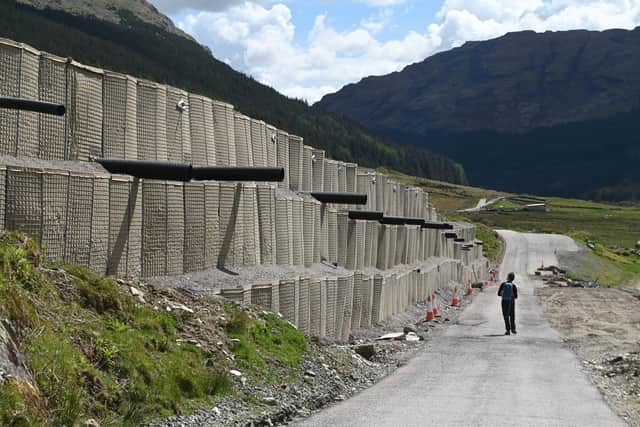
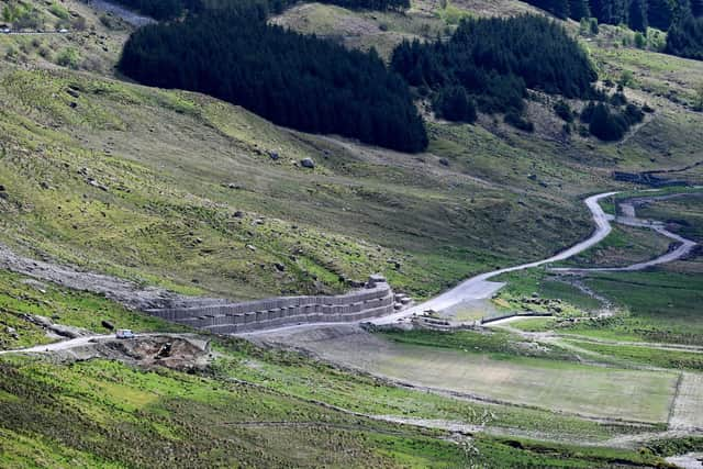
But the giant sacks of gravel stacked 20ft high and stretching nearly 600ft symbolise the last line of defence in Scotland’s latest battle against climate change.
The huge bund is the backstop if all else fails should another landslip send thousands of tonnes of rocks and debris down the steep Glen Croe hillside and engulfs the A83 road near the Rest and Be Thankful pass.
Advertisement
Hide AdAdvertisement
Hide AdIt has been built to protect the old route – the Old Military Road – which runs below and parallel to the A83, to prevent it too from being blocked and unable to perform its role as an emergency diversion route, as has happened in the past.

Evidence of one of the biggest landslips to date, which happened last year, has only just been removed, as this dramatic drone video by Scotsman photographer John Devlin shows..
A newly-sowed field just below the bund belies the devastation caused when debris covered it after smothering both the A83 and Old Military Road, reaching nearly as far as the River Croe on the floor of the glen.
The bund is a tacit admission that despite the various protective measures to guard the A83 further up the hillside, the sheer force of future rockfalls could again render them impotent.
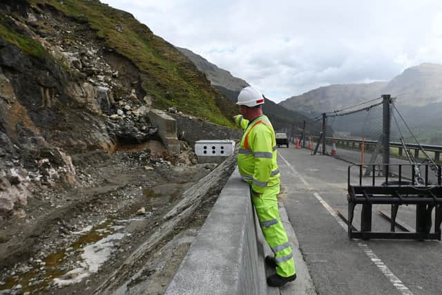
Over a half-mile stretch of the A83, work is continuing on a network of fencing, barriers, rock pinning and cavernous “catch pits” in attempt to halt further landslips in their tracks.
The heavy-duty metal hillside fences look strong enough to catch runaway vehicles careering down the slopes.
By comparison, the traditional wood and wire sheep fence above them looks paltry, even comically fragile.
Meanwhile, the catch pits being excavated along the side of the carriageway are effectively a modern-day moat between road and hillside.
Advertisement
Hide AdAdvertisement
Hide AdAlong the centre of the A83 itself, 8ft high fencing has been drilled into the Tarmac to provide another line of defence, with vehicles sharing the one remaining lane in a traffic light-controlled contraflow.

But to the untrained eye, the variety of defences look like bets are being hedged as to where the new landslip will strike. “Take your pick,” one worker joked.
Several hundred feet above, “spotters” with full-length orange hi-vis clothing and white helmets patrol the hillside during daylight to provide early warning of movement over the most unstable stretch so the road can be quickly closed if necessary.
At night, “sentries” keep watch from road level.
Walking beside that section of the A83 last week, I was asked not to stop there, such is the threat from another rockfall.
Yards away, sheep nonchalantly continued to nibble the grass.
Down the slope, nature is starting to help heal the scars of the last landslide, new bracken shoots growing through the rubble.
But the remains of a fence smashed apart and traffic cones and other debris strewn down the hillside bear witness to what has gone before.
According to a Forestry Commission sign in the Rest and Be Thankful car park at the head of the glen, its name was taken from the words inscribed on a stone there by soldiers who built the military road in the 1740s.
Advertisement
Hide AdAdvertisement
Hide AdThe steep and twisty route, which the Motoring in Scotland book said cars used to climb “like flies on a wall”, was replaced by the current straighter A83, higher up the side of the glen, in 1941.
The 1953 guide noted: “The reconstruction has not only modified the gradients from one-in-six and one-in-seven to one-in-15 and one-in-20, but has completely cut out the summit hairpin, and other less violent bends.”
However, a retired local authority geotechnical engineer, who asked not to be named, said it had been built in the wrong place – “on the north side of the valley of the River Croe, which suffers the greatest amount of weathering, rainfall and erosion.
"The road was constructed as a single gradient from bottom to top, benched into a highly hazardous side slope.
"Bridges and structures were only designed to take the water flow, but not the copious quantities of debris flowing off the hill face, so are therefore inadequate.”
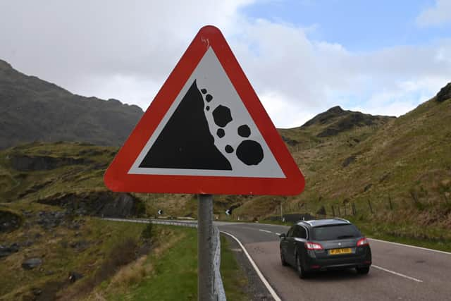
In recent years, that stretch of the A83 – the main route between Glasgow and Kintyre – has become Scotland’s landslide hotspot, with a total of 20,000 tonnes of debris hitting the road in 15 incidents since 2007.
Half of that fell in a single landslip last August, with a further 5,000 tonnes deposited the following month.
Up to a further 100,000 tonnes has been identified as being in a “new slip area”.
Advertisement
Hide AdAdvertisement
Hide AdMitigation work – which has caught 6,650 tonnes from spilling onto the road so far – has been progressively stepped up, with £15 million spent and work ongoing.
The traffic light contraflow, to keep the workforce safe and enable heavy machinery to be moved, is due to remain for much of this year until the work is complete.
Overnight, vehicles are shepherded through in escorted convoys.
However, there have been frequent closures since August because of the threat of further rockfalls, with traffic diverted onto the single-track Old Military Road also using a convoy system.
Road maintenance firm BEAR Scotland, working for Transport Scotland, said current activities included strengthening and extending roadside debris fences, stabilising boulders, improving drainage channels and building a new catch pit.
Research is also ongoing into the hillside’s topography to help predict how it might move to inform where extra protective measures are required.
Monitoring includes equipment embedded in the hillside, time-lapse cameras and visual markers.
Deer fencing is being installed so tree planting can start this autumn to help stabilise the ground.
Advertisement
Hide AdAdvertisement
Hide AdThe aim is to prevent further landslides from blocking the A83, or at least the Old Military Road, to avoid a detour of up to 60 miles.
However, the Scottish Government’s Transport Scotland agency, which is in charge of the work, said despite all the extra fencing, barriers, a pit and drainage improvements installed last August – along with the bund – the route still had to be closed to traffic eight times this year.
The increasing disruption led to Transport Secretary Michael Matheson announcing weeks after the August landslide that the road would be bypassed to provide a “long-term solution”.
Eleven potential corridors, including bridges or tunnels across the Clyde, were narrowed to the preferred option of a new stretch of the A83 parallel to the existing road through Glen Croe.
Five potential routes, that include tunnels and a mile-long viaduct, were unveiled in March.
They are estimated to cost £268m-£860m and could take ten years to complete.
Mr Matheson, who was reappointed as transport secretary last week, has told MSPs it is an “emergency project” that must be progressed at “rapid speed”.
He also pledged that plans for a “medium term resilient route”, potentially using the Old Military Road and upgraded forestry tracks, should be finalised by autumn next year.
Advertisement
Hide AdAdvertisement
Hide Ad
However, the minister’s pace has failed to impressed locals, who have launched a new lobby group to press for swifter progress after the nightmare of the last nine months.
Fed up with the increased disruption from landslides, local businesses have formed the Rest and Be Thankful Campaign to press for the permanent replacement road to be completed by the end of the current Scottish Parliament in five years’ time.
Chair John Gurr, from Inverneill, near Lochgilphead, said the plans must be accelerated.
He said: "This is an emergency – it is a disaster for Argyll and needs to be treated as such.
"We should cut through a lot of the statutory consultation processes, because who is going to object?
"You’ve got all of the population of Argyll behind us, all of the businesses, the politicians and the council.
"Nothing can be worse than what has already been done – the scouring out of the side of the hill with catch pits, which they have not gone to consultation on.”
Mr Gurr, a retired supply chain director, said the scale of the threat of further landslips underlined the urgency of the situation.
Advertisement
Hide AdAdvertisement
Hide AdHe said: “The amount of material that is coming down every year has grown exponentially.
"There’s 100,000 tonnes of unstable material and the trajectory is that most, if not a significant part of that, will come down at some point this year.”
Mr Gurr said the road closures had caused huge problems, with hauliers complaining that the trickiest part of their entire world distribution networks was negotiating the Rest and Be Thankful.
He said this had cost the haulage industry £2.3m, while tankers could not use the Old Military Road because of its steepness.
Bus operators’ costs had increased by 15 per cent and the day trip market from Glasgow in Inveraray and other places virtually dried up in August and September.
Mr Gurr added: “Residents of Argyll rely on hospitals in Glasgow for critical health services and treatments.
"The current situation is causing disruption and distress to patients and relatives - the sheer uncertainty is affecting their mental health and well being.”
A new cross-party group of local MSPs is also being formed to push for faster consultation over the new road plans.
Advertisement
Hide AdAdvertisement
Hide AdDumbarton Labour MSP Jackie Baillie said: “It is vitally important the consultation for the replacement for the A83 at the Rest and Be Thankful is carried out quickly.
"The ongoing problems with the A83 have been hugely disruptive to the lives of local people – and have had a really negative impact on the local economy.
"Local people and businesses have waited long enough and they need urgent solutions.
"That starts with a new temporary road and the procurement process for a permanent replacement needs to be hastened.”
However, building a permanent new road on the other side of the glen does not come without its own risks, as a Transport Scotland report in 2008 warned.
It cautioned that such a project “should not be considered lightly”.
The report stated: “While recent debris flows have not been observed historically on that side of the valley, the disruption to the landscape caused by the construction and maintenance of a road could well lead to a change from the current situation.”
That was echoed in the latest consultants’ report into the scheme, published last month, which said there were landslide risks to aspects of all five options, including during construction.
Advertisement
Hide AdAdvertisement
Hide AdHowever, Graham Edmond, a former chair of the Institution of Civil Engineers Scotland, said a new road would reduce the risks, while landslides posed an ongoing and unpredictable threat to the existing road.
He said: "The likelihood of increased rainfall and the effect of that on landslides is likely to increase over the next few years because of climate change.
“Landslides are a natural phenomenon and that particular hillside is always going to be prone.
“Soil coverage on the hillside is very thin, and is coming down from 1,000-1,500ft above the road during landslides.
"Once moving, that gets a large momentum and it’s quite difficult to stop.
"The catch pits and debris flow netting have been successful in reducing but not eliminating the likelihood of landslides closing the road over the last ten years.
"The science is developing and the knowledge of the hillside is increasing.
“If that road’s closed, it’s a very long diversion and it’s certainly quite important for the people of mid Argyll because the road is really the only way in apart from the ferry to Dunoon, which is quite a long way round, and there’s no railway.”
Advertisement
Hide AdAdvertisement
Hide AdMr Edmond added: "Transport Scotland has done quite a lot of predicting the majority of the landslide locations that come down from the hillside, but unfortunately the most recent landslide probably wasn’t exactly where it was predicted as it is not possible to be 100 per cent accurate.”
He said he was confident about the proposals for re-routing the A83: “The plans should very significantly reduce the likelihood of landslides closing the road in the future.”
However, he warned against focusing on that project at the expense of other risk areas.
While all eyes may currently be on the A83, dozens of people had to be airlifted to safety after their vehicles were trapped between two landslides on the A85 in Glen Ogle, north of Lochearnhead, in 2004, a week after cars were engulfed in debris on the A9 north of Dunkeld.
Last year, in the most serious landslide on the Scottish rail network for decades, three people were killed when a train hit debris at Carmont, south of Stonehaven, in August.
Mr Edmond said: "It’s important that all the potential landslide sites around Scotland are looked at.
"If you put all of your eggs in one basket, in terms of all of the investment being allocated just to the Rest and Be Thankful, that reduces the likelihood of investment being available for other areas around Scotland."
Mr Edmond said other risk areas on major roads included the A77 between Girvan and Stranraer, the A76 between Cumnock and Sanquhar, and parts of the A82.
Advertisement
Hide AdAdvertisement
Hide AdEddie Ross, north west representative for BEAR Scotland, said it had “worked round the clock in difficult conditions to re-open the A83 as quickly as possible” after each landslide.
He said: “Since the events of August and September last year, teams have been working 24/7 to continue with a programme of further mitigation measures in the area, as well as strengthening and repairing the existing resilience measures in place.
“We thank motorists as well as the community for their ongoing patience while we complete this vital work.”
A Transport Scotland spokesman said: “The resilience of the A83 at the Rest and be Thankful has deteriorated over the course of the last year.
"Between 2007 and mid-2020, we undertook proportionate methods to maintain connectivity.
"However, the recent situation, based on a series of landslides starting in August 2020, has called for further, and more extensive, action.
“We can assure local residents and road users that the situation is being treated with seriousness and urgency, with measures to maintain connectivity through the glen being expedited on a short, medium and long term basis.
“In March, we announced a preferred corridor for a long-term solution to the landslips, along with potential route options within that corridor, for consultation.
Advertisement
Hide AdAdvertisement
Hide Ad“As part of our plans, we are also developing a medium-term solution to provide resilience while the long-term solution is developed.
"We are examining options in and around the forestry track on land owned by Scottish ministers, along with potential upgrades of the Old Military Road.
"Depending on the consents required, those proposals could be finalised in 18 months.
“Consultants are being procured to progress the design of options, and as with other projects to improve the trunk road network, there will be a need to complete the necessary engineering and environmental assessments, as well as the statutory process, to allow land to be acquired and the project constructed.
“We recognise the timescales for developing an alternative to the current route and finding a long-term solution to the challenges created by the Rest and Be Thankful section of the A83 are frustrating for the local community and we will look to expedite the programme where possible.
"However, we must ensure we follow the correct statutory process to ensure a fair and transparent assessment of options and impacts on local communities and road users.”
Heading home from my Rest and Be Thankful visit, it started raining, and as I stopped at the landslip site traffic lights, I noticed water running along the edge of the road that hadn’t been there earlier.
An innocuous sight anywhere else, it felt strangely unnerving on that notorious Argyll hillside.
A message from the Editor:
Thank you for reading this article. We're more reliant on your support than ever as the shift in consumer habits brought about by coronavirus impacts our advertisers.
If you haven't already, please consider supporting our trusted, fact-checked journalism by taking out a digital subscription.
Comments
Want to join the conversation? Please or to comment on this article.