Soldier's 3D map of Scotland celebrates Polish independence


Now, the Great Polish Map of Scotland – the world’s largest 3D terrain relief model of a nation, which had lain abandoned, damaged and overgrown, has been restored to its former glory and will be unveiled on 12 April in the Scottish Borders.
Its remarkable restoration, by a team of volunteers, coincides with the 100th anniversary of Polish independence in 1918 after it was partitioned by Russia, Prussia and Austria in the 18th century.
Advertisement
Hide AdAdvertisement
Hide AdThe massive model of Scotland and its islands, measuring 50 metres by 49 metres, is surrounded by water representing the sea and can be seen from a viewing tower.
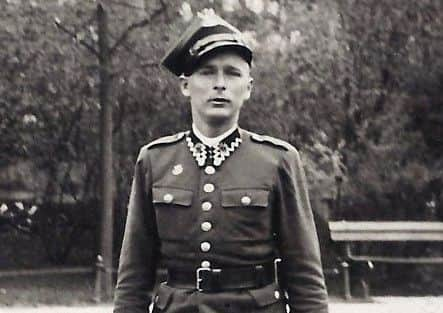
Jan Tomasik, of the 1st Polish Armoured Division under the command of General Stanislaw Maczek, was one of around 17,000 Polish troops who arrived in Scotland in 1940 to defend the east coast of Scotland, which was under threat of invasion from the Germans following Hitler’s occupation of Norway.
After the war, Tomasik stayed in Scotland and married Catherine Kimlin, a Scottish nurse, and became a hotelier.
In 1968 he bought Barony Castle Hotel near Eddleston, which had been requisitioned during the war and became the main Polish Forces’ staff training college.
In 1975 he recruited a team of Polish geography students to build his dream map under the guidance of Dr Kazimierz Trafas, a distinguished cartographer and a lecturer at the Jagiellonian University in Kraków, with work continuing until 1979.
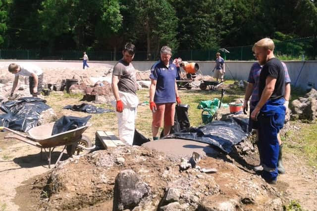
However, it fell into disrepair, until Keith Burns, an engineer who was attending a conference at the hotel in 1996, almost fell into a hole in the ground covered by undergrowth. He soon realised he had stumbled on to something unique.
“The first clue was when I saw a shape which looked like the Mull of Galloway,” said Burns, “I thought I must be imagining it. I decided I had to look further and found the Isle of Arran.
“The whole pit area was a jungle. But I managed to walk over Ben Nevis, Rannoch Moor and reached Cape Wrath – I walked the whole of Scotland. But no-one at the hotel reception desk could tell me anything about it.”
Advertisement
Hide AdAdvertisement
Hide AdBurns, now retired, set up the Mapa Scotland charity in 2010 and recruited volunteers to restore the map.
“It took us ten years, it was hard work and the average age of the volunteers was 68.
“The important thing now is that it should become a historic monument to remind young people about the links between our two countries.” said Burns, who obtained category B listed monument status for the map from Historic Scotland.
Ireneusz Truszkowski, Consul General of the Republic of Poland in Edinburgh, said: “We are delighted to be able officially to unveil the restored Great Polish Map of Scotland in the same year in which Poland is celebrating its 100th anniversary of regaining independence.
“The map is one of the symbols of the commitment of Polish people and Polish soldiers to the rich history of the Polish paths to independence.
“The restoration has been made possible thanks to the enormous contributions of many, mostly Scottish friends, who have given their time to this project for many years. We owe a great depth of gratitude to them.’
Fiona Hyslop, cabinet secretary for culture, tourism and external affairs, said: “The Great Polish Map of Scotland is a fine example of Scotland’s ties and friendship with Poland. The project further strengthens the long-standing cultural connections between our two nations, while emphasising our shared history and heritage.
“We are pleased that thousands of Poles, almost half of all EU nationals in the country, have chosen to make Scotland their home. Their contribution to our economy and society is greatly valued. I look forward to visiting the map site again in April this year and to celebrating the centenary this November of Poland regaining its independence.”