Revealed '“ Soviet spies' secret map of Aberdeen, a city ripe for invasion


The map is revealed in a new book examining 500 years of military mapping in Scotland.
The detailed map of Aberdeen, a city which suffered severe bombing during the Second World War, gives precise measurements of many features, including the widths and lengths of the Victoria Bridge and Wellington Suspension Bridge over the River Dee.
Advertisement
Hide AdThe mapmakers colour-coded buildings by function – green for military, purple for civil administration, black for industrial and brown for residential. This is accompanied by a ‘spravka’ essay of more than 1,800 words focusing on 58 important objects, which notes the coastal area north of the city is “suitable for amphibious landing” and the impressive “harbour dockage facilities can provide complete overhaul of vessels, including destroyers”.
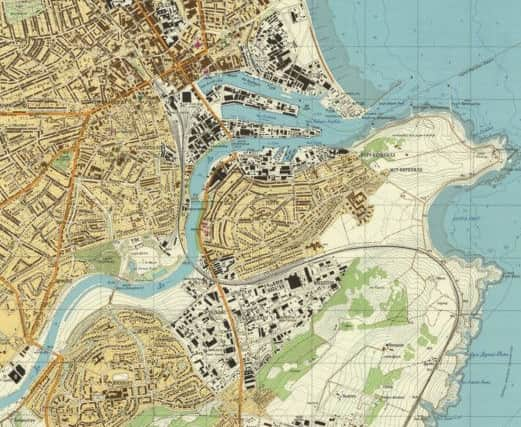
The spravka included details such as the land around the city being “dissected by deep river valleys that are the major obstacles for non-road mobile machinery”, that its quarries could be used for shelters and that “Aberdeen seaport is the major maintenance base for oil deposits in the North Sea”.
Scotland: Defending The Nation – Mapping A Military Landscape by Carolyn Anderson and Christopher Fleet includes military maps from the 15th century.
Others date from the Jacobite Rebellions of the 18th century and from the two world wars.
Ordinary people have not been forgotten. The collection also features a civilian CND map entitled “Scotland: No Place for Nuclear Weapons” used by campaigners in the 2014 independence referendum. The SNP had said Scotland would be made nuclear-free if the nation became independent.
Fleet, maps curator at the National Library of Scotland in Edinburgh, said military maps became available in Estonia, Lithuania and Latvia after the fall of the Soviet Union. “The Russian Military Mapping Institute employed around 36,000 people at its height,” he said. “Its people mapped 2,000 cities of strategic importance worldwide. The maps were not just about attacking cities, but tools to occupy cities and countries once the invasion had taken place. Scotland was being mapped by external aggressors.”
Advertisement
Hide AdIn Scotland, Soviet agents focused on Aberdeen, Edinburgh, Glasgow, Dundee, Greenock and Kilmarnock.
Alan Donnelly, depute provost of Aberdeen City Council, said Europe had been very volatile and divided. “This was a time of high tension and SS-20 missiles were poised in central Europe for attack,” he said.