100 weeks of Scotland: birthplace of geology


It has a bleak majesty all of its own. From the long sandy beaches of East Lothian to the treacherous and imposing sheer cliffs of Berwickshire this is an area of Scotland that is often bypassed by the headlong rush of the A1 road, or the clifftop hugging east coast railway line to London.
The John Muir Country Park north of Dunbar was named in honour of local man John Muir; one of the pioneers of the environmental movement. A fierce advocate of the preservation of the wilderness and a prime mover in the creation of National Parks in his adopted country of the United States. It is a beautiful area with long white sands stretching from north to south, tidal lagoons and forest. The occasional wartime tank traps still lurk in the undergrowth reminding you that the east coast of Scotland has for millennia been a place of watchers - peering into the gloom of the storm-tossed sea and awaiting attack from The Vikings, the Nazis or the Soviets. Not today though, as a chill northern wind whips the waves and sends clouds careering south, with me in their wake.
Advertisement
Hide AdAdvertisement
Hide AdThe harbour at Dunbar has over the years seen many types of goods pass through it, most notably herring in the nineteenth century and potatoes in the early twentieth, and was a major player in the whaling industry. Today there is a bustle around the harbour as numerous small boats are being prepared, ready to set sail in search of the shellfish that today are the main catch in the area. I photographed one of the fishermen as he took a break from overhauling the engine on his boat. The waves pounding onto the seawall south of the harbour are a reminder of how dangerous these seas can be.
Heading south towards my next location I passed two of the main industrial landmarks in the area – The Lafarge cement works and the Torness Nuclear Power Station, both imposing buildings and all the more obvious as they rise grimly from the flat farmland around them.
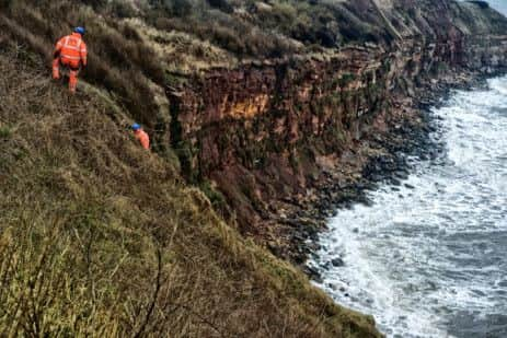
I reach the tiny village of Cove just as an almighty hailstorm unleashes fury for 60 seconds before suddenly stopping. Within moments the sun has returned. It is one of those spring days that sees all the seasons come and go on a regular basis. Heading down the coastal path to the harbour, workmen are roped together working on the cliff top. It looks terrifying and soon I will learn how they feel.
There has most likely been a harbour at Cove since pre-history with the most recent incarnation dating from the early nineteenth century. Again it was a centre of the herring trade and was once an extremely busy area. It is deserted today with only a couple of small boats moored together. The photo I took shows just how wonderfully undeveloped the harbour is. It looks exactly as it did two centuries ago. Seconds after I took the shot a huge wave came over the harbour wall completely drenching me, and my poor dog. For the 74th time since I began this project 74 weeks ago I wondered again just why I had ever started it…
Siccar Point, a few miles south of Cove, is possibly the most famous geological site on the planet. It was here, in 1788, that the Scottish geologist James Hutton observed the differing rock strata that provided proof of the widely held belief that the earth was billions of years old rather than the few thousand as stated in the bible. The weather had changed again and as I walked along the clifftop path, the hailstones lashed down once more and the wind rose. Soon I was at the top of the cliff path (I use the term ‘path’ very loosely) staring down at Siccar Point. I was, quite frankly, terrified. At the bottom, among the rocks and the crashing waves, was Hutton’s Unconformity. The actual rocks that inspired his theory. I had no choice - I had to go down. Minutes later, halfway down a greasy, muddy, almost vertical slope, grasping my dog’s lead with my left hand, my tripod under my arm, with all my camera gear on my back - and a white-knuckled right hand clamped around the extremely flimsy guide rope I thought - for the 75th time (and, judging by my predicament, possibly final) why did I start this?
I made it down. Somehow. Windswept, wet, covered in the rich red mud of Berwickshire and with an aching knee where I had slipped on a boulder, I stood on the narrow shelf of land between the cliffs and the raging North Sea and looked around. It all just looked like rocks. sharp, slippery rocks. I photographed everything I saw because I knew I would never, ever come back here. Hutton had correctly surmised that the vertical greywrack rocks must have been warped by volcanic activity and then overlain by the horizontal red sandstone and this process must have taken place over aeons of time. He was a much cleverer man than me – he came by boat.
After a short rest I began the terrifying climb back up. Halfway to the top, I looked briefly back down at Siccar Point. The sun had come out and it looked beautiful – all golden against the dark sea. A braver man than me would have somehow got his camera out and got the shot. Me? I couldn’t have cared less by this point. I wanted a cup of tea on solid, level ground.
It was sunny when I reached St Abbs. I hobbled around the lovely old harbour (I really had hurt my knee it seemed) and photographed a few boats and a lovely old fisherman’s hut before limping toward my final destination, the harbour café. It’s amazing what a mug of tea and a massive bun can do for the soul.
Advertisement
Hide AdAdvertisement
Hide Ad• Alan McCredie began the ‘100 weeks of Scotland’ website in October last year, and it will conclude in Autumn 2014. McCredie’s goal is to chronicle two years of Scottish life in the run-up to the independence referendum.
Alan says ‘one hundred weeks...’ is intended to show all sides of the country over the next two years. On the site, he says: “Whatever the result of the vote Scotland will be a different country afterward. These images will show a snapshot of the country in the run up to the referendum.
“The photos will be of all aspects of Scottish culture - politics, art, social issues, sport and anything else that catches the eye.”
Follow the project at 100weeksofscotland.com. You can also follow Alan on Twitter @alanmccredie.