Walk of the week: An Aberdour Circuit


The village grew as a seaside resort in the 19th century; a development enhanced from 1890 with the building of the railway line east from the newly opened Forth Bridge, and which offered a convenient half-hourly train service to Edinburgh.
I too arrived by train, to be met by Jimbo. Aberdour is crossed by the Fife Coastal Path, but we were bound for an 8 mile hinterland circular walk; more demanding than might be expected because of an overall climb of 300m, some of it over roughish terrain. Fife Core Paths map 58 may be more useful than Ordnance Survey map 66.
Map Ordnance Survey map 66, Edinburgh
Distance 8 miles
Height 300m
Terrain Tracks, paths and minor roads
Advertisement
Hide AdAdvertisement
Hide AdStart point Aberdour railway station car park, map ref 191854
Time 4 hours
Nearest village Aberdour
Refreshment spot McTaggart’s café deli, 21 High Street, Aberdour
THE ROUTE
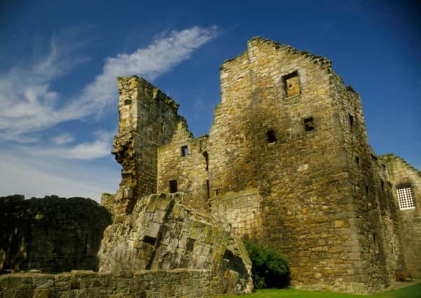
From Aberdour railway station car park, follow a Tarmac pathway between the railway and the semi-ruined Aberdour Castle, of which the oldest part constitutes one of the earliest stone castles in mainland Scotland.
Reach a road, turn left over the railway, then right on Main Street, the A921, which is followed to the east end of the village. The A921, with a pavement on the right, heads up Mains Brae. When the road curves right, cross most carefully (note the Fife Core Path purple sign), then immediately right as signposted, Dunearn.
A gently rising path through a charming wooded strip (known locally as Kamal’s Cut) leads to Long Gates cottage. Now into open country, showing to the right is the top of the Craigkelly mast and the Binn, the 632ft/193m volcanic plug that overlooks Burntisland. A farm track heads direct to the A909 and by now at a height of 170m. Fife Core Path map 58 indicates a diversion to avoid the road descent towards Stenhouse Reservoir. This diversion has yet to be developed, so descend on the oft-busy road.
Turn right towards the 35-acre Stenhouse Reservoir, a trout fishery centre, but for 90 years part of the Fife water supply until decommissioned in the 1990s. Leaving the loch behind, take the higher lane, later a grassy track between fields, to reach Balmule farm. Cross the B9157 to a minor road, Puddledub ¼ mile, then turn left on the signposted historic Old North Road.
The next mile, curving westwards to reach the A909, may take longer than expected. Pass through a rougher section to enter a wood where the path is not overly obvious. There are a couple of green Scotways signs; also some white plastic strips periodically tied to trees – a novel approach. The Old Road eventually becomes a broad grassy way, finally with a sharp turn to the left and so to a stile by the A909.
Enter the Forestry Commission Cullaloe mixed woodland. The forestry track rises steadily to the Cullaloe Hills and with views of the route so far walked. Pass the distinctive Cullaloe Temple, a listed building; a 19th century octagonal folly constructed from locally quarried sandstone. The track curves to the left and descends past danger signs surrounding the 19th century Goat Quarry, closed for more than 50 years then re-opened in 2004. Its pale-buff sandstone is an exact match for Craigleith stone from which much of Edinburgh was built, hence solving the problem of the city’s crumbling sandstone buildings. The path/track follows the perimeter of the fenced off massive quarry, more than 1km long with high hewn rock faces surrounding the flooded centre.
Advertisement
Hide AdAdvertisement
Hide AdIt is then an easy descent to a minor road, then left past Old Whitehill cottage and the remains of a dovecot, to reach the crossroads with the B9157. As a well-known vehicle accident site, cross with extreme care. A pavement, later by the Dour Burn, leads back to Aberdour.
FOLLOW US
SCOTSMAN TABLET AND MOBILE APPS