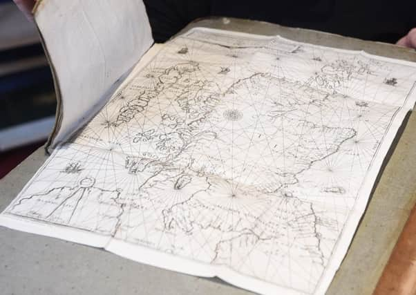
Map believed to be oldest chart of Scotland set to go under the hammer


Now, nearly five hundred years after its creation, a map believed to be the oldest chart of Scotland is to go under the hammer.
With its intricate and authoritative illustrations, Nicolay d’Arfeville’s masterpiece presented a snapshot of the nation’s headlands, inlets, and archipelagos, and proved even more accurate than maps produced centuries later.
Advertisement
Hide AdAdvertisement
Hide AdThe document, better known as the Nicolay Ruter, is regarded as a turning point in cartographic history, but its value is also inextricably linked to its political history.
It is believed to have been drawn up from the sea voyage taken by Scotland’s renaissance monarch in 1540, which saw his fleet sail to the Firth of Clyde from the Firth of Forth.
The journey was made in part to satisfy the king’s wanderlust, yet it also allowed him to pacify troublesome factions in the Western Isles.
d’Arfeville, a geographer and cosmographer, produced the work based on extensive drawings made by Alexander Lyndsay, a pilot who accompanied James on his trip.
The map’s precision made it an invaluable - and powerful - tool, and by 1547, it had found its way into French hands.
Henri II’s forces used it to navigate to St Andrews to avenge the murder of Cardinal Beaton, the last Scottish cardinal prior to the Reformation.
The resultant siege saw St Andrews Castle bombarded. In the attack’s aftermath, John Knox was among those captured and confined to the French galleys.
Fittingly, Lyon & Turnbull, the Edinburgh auction house which is selling the Nicolay Ruter, said there had been international intrest.
Advertisement
Hide AdAdvertisement
Hide AdSimon Vickers, a book specialist at the firm, described it as an “intriguing highlight” of its upcoming sale of rare books, manuscripts, maps, and photographs.
“The rutter takes its name from the French word routier and is a set of sailing directions,” he explained.
“Nicolay’s map marks a huge step forward in the accuracy of cartography, not only is the shape of Scotland instantly recognisable, it is much more accurate than the later Gordon Blaeu map of 1654 and the Moll map of 1714.”
Given its significance to the evolution of cartography, and its role in Scotland’s turbulent political history, the map is estimated to sell for between £15,000 and £20,000.