Weather: Seven airlifted to safety in Dumfries


The group of people, which included four children, were rescued from a farmhouse near Closeburn in Thornhill, Dumfries and Galloway, by a Royal Navy helicopter from HMS Gannet at Prestwick in Ayrshire. after rain forced families to be evacuated from dozens of homes and caused major road disruption.
Torrential rain and flooding caused chaos across southern and western parts of Scotland – and the wet and windy conditions are set to continue into the new year.
Advertisement
Hide AdAdvertisement
Hide AdHowever, first footers are expected to be given some respite as conditions are forecast to settle briefly as the bells signal the beginning of 2014.
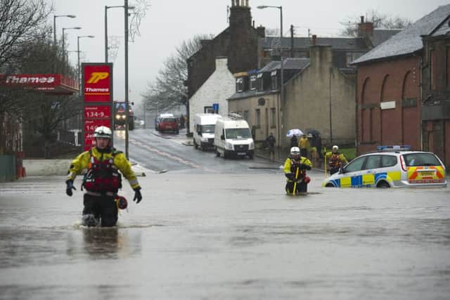
Forty houses in Kirkconnel, Dumfries and Galloway, were evacuated, as were 25 in Dumfries after the Nith burst its banks.
Firefighters yesterday evacuated more than 14 people from flooded properties in the town of New Cumnock, Ayrshire.
The weather conditions blighted travel for many as high winds and rain closed roads and forced the cancellation of ferries.
The Met Office has issued an amber “be prepared” warning for parts of Dumfries and Galloway and South Ayrshire and a number of yellow “be aware” warnings for rain over other regions, including Central, Tayside, Grampian and the Highlands.
A Met Office spokesman said: “Hogmanay will see a band of rain come across the whole of Scotland during the morning. There will be drier and brighter weather for a time, especially around midnight.”
Yesterday, the A76 Cumnock to Sanquhar road and the A713 Dalmellington to Castle Douglas roads were blocked.
In the village of Carsphairn, Dumfries and Galloway, residents described the conditions as some of the worst they had experienced in 40 years. Several properties were reported to be under water, while rescue services removed a stranded car on the A713 road, which runs through the village.
Advertisement
Hide AdAdvertisement
Hide AdEmergency services also helped residents hit by flooding in Port Logan on the Rhins of Galloway.
The Whitesands area in Dumfries was flooded after the Nith burst its banks. Water levels were being monitored on a number of other rivers including the Cree in Newton Stewart.
The A701 was blocked by flooding south of Moffat after a lorry and car got stuck in the water.
In Glasgow, the M77 southbound entry slip was closed because of flooding at junction two Barrhead Road. Some vehicles broke down after trying to negotiate flood water under a railway bridge on Pollokshaws Road in Glasgow.
The M77 motorway was closed for a while due to flooding at junction two at Pollok, next to the busy Silverburn shopping centre.
Nearby, Police Scotland had to evacuate dozens of animals by boat after its Dog Branch service in Pollok Park was inundated by the White Cart River, which burst its banks. At the King George V playing fields in Thornliebank, goalposts were almost totally submerged by the floods.
Trains from London Euston to Edinburgh and Glasgow were also disrupted by flooding.
Virgin Trains said there were no services running between Carlisle and Carstairs, due to flooding between Lockerbie and Carstairs.
Advertisement
Hide AdAdvertisement
Hide AdTrains were also affected after a body was discovered on the tracks at Kirknewton in West Lothian. The First TransPennine Express from Manchester Airport to Edinburgh and Glasgow Central was also affected by the weather.
A total of 52.6mm of rain had fallen in Threave in Kirkcudbrightshire between 10pm on Sunday and 10am yesterday.
Scott Lees, head of network operations at Transport Scotland, said: “Although we would expect to see fewer people travelling at this point in the holiday season, we would advise people to prepare for this, drive to conditions and allow extra time for any journeys they are planning to make.”
THE FORECAST
Rain was set to dampen today’s start, but revellers were expected to enjoy a brighter Hogmanay as the rain clears in time for the bells.
However, wet weather and strong breezes are due to return, with warnings in place for south west and central areas, with the possibility of up to 20mm of rain.
An area of low pressure will generate gusts of 50-60mph along the west coast, but will move away on Wednesday evening, with Thursday set to be breezy, but drier.
The Met Office said storms are forming on the eastern coast of the US and “shooting” straight at us.
FULL LIST OF SEPA WARNINGS
Dumfries & Galloway
• Water levels are still rising and the peak at Dumfries is not expected till later this afternoon.
Advertisement
Hide AdAdvertisement
Hide Ad• Newton Stewart and other places across Dumfries and Galloway: River levels are still rising and are similar to levels in the 2001 event. Property flooding is very likely.
• Reports from the Council of flooding at several locations including Johns Town of Dalry, Kirkcudbright and the A712.
Ayrshire and South Glasgow
• Irvine: Levels are rising anmd a warning is possible which, if it happens, would affect properties on Queens Drive.
• White Cart in Glasgow: A warning has gone out for Pollock park (not property flooding) but levels are close to peaking.
• Kelvin and Clyde: Levels are now rising in both these rivers and we are keeping a close eye here.
Borders
• Upstream of Peebles. Two warnings have gone out upstream of Peebles in places like Dawyck. Localised property flooding, and flooding of a minor road is a risk here.
• Peebles. No warnings have been issued as yet. We are closely monitoring Peebles itself but so far it looks like a road is at risk but beyond that we are not expecting extensive property flooding here.
• Hawick. Levels are still rising. The flood gates are closed so Hawick is protected thus far, but isolated properties are at risk in the agricultural land just downstream of the town.
Advertisement
Hide AdAdvertisement
Hide Ad• Ettrick Valley: Two caravan parks and the access road to a property at risk.
Edinburgh
• The Braid Burn being monitored, but levels are still low and the peak is not expected till after lunchtime.
Tayside
• Comrie: Levels were a concern overnight but the peak is falling away.
• Bridge of Earn. We are keeping a close eye on the town, but flooding - if it occurs - would not be till much later in the day.
• Other areas: Levels in the main rivers are still rising. Flood warnings have already been in place since before the weekend. Significant property flooding is not currently expected in Tayside. Minor road closures likely in Dundee-Angus later in the day.
SEE ALSO: