Scotland faces being struck by a ‘weather bomb’


The Met Office warned of winds of up to 80mph and “exceptionally high waves” – to be followed by snow and further problems on Friday.
The Western and Northern Isles are most likely to be hit, where an amber “be prepared” warning is in force until 6pm.
Advertisement
Hide AdAdvertisement
Hide AdDrivers were warned of “dangerous conditions” on causeways and coastal roads.
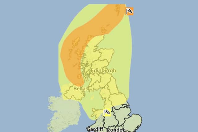
The rest of the country is covered by a yellow “be aware” alert until 6am tomorrow.
A precursor to the phenomenon – caused by violent winds generated by rapidly-falling pressure – came yesterday, with 66mph gusts disrupting ferries and creating driving hazards.
Waves the height of six-storey buildings formed in the Atlantic, and were nearly 29ft high off the Western Isles.
The winds reached 99mph on Aonach Mòr, beside Ben Nevis, and 55mph in Edinburgh.
There were nine flood warnings in force last night, where the Scottish Environment Protection Agency (Sepa) said flooding was expected and immediate action was required.Risk areas include several streets in Fort William and nearby Corpach and Caol, around high tide on Loch Linnhe at 7am.
The River Leven could flood streets in Dumbarton at high tide at 3pm, while Deephope and Hopehouse caravan parks beside the Ettrick Water in the Borders were also threatened.
Transport chiefs have closed swathes of the rail network and ten west coast ferry routes today as a precaution. Network Rail said no trains will run on the West Highland line between Glasgow and Oban and Mallaig, or from Inverness to Wick/Thurso or Kyle of Lochalsh.
Advertisement
Hide AdAdvertisement
Hide AdThe other lines closed are Ayr to Stranraer, Kilwinning to Ardrossan/Largs, and Dumbarton Central to Helensburgh Central.
Network Rail said it would have hundreds of engineers ready to remove fallen trees and repair damaged equipment.
Route managing director for Scotland David Dickson said: “Safety has to be our first consideration during severe weather and we are withdrawing a limited number of services until the worst of the storms have passed.”
ScotRail warned replacement buses would depend on roads remaining open, and urged passengers to travel tomorrow instead. ScotRail deputy managing director Kenny McPhail said: “While replacement buses may be available at key locations, they cannot be guaranteed due to likely road conditions.”
No CalMac ferries will operate on routes such as those to Colonsay, Islay and Lewis.
Drivers were warned the Forth Road Bridge, which carries some 66,000 vehicles a day, is likely to be shut to all but cars.
CONNECT WITH THE SCOTSMAN
• Subscribe to our daily newsletter (requires registration) and get the latest news, sport and business headlines delivered to your inbox every morning
Advertisement
Hide AdAdvertisement
Hide AdAll 26 schools and every council-run nursery in the Western Isles will be closed, along with sports centres and libraries.
The Met Office said winds would gust to 70-80mph in the amber warning area. It said: “Very strong winds are likely to affect northern and central parts of the UK from early Wednesday and last until early Thursday.
“Very large swell generated over the Atlantic to the south of the very deep depression will lead to exceptionally large waves affecting west coasts.
“There remains some uncertainty in the precise depth of this low and therefore in the exact wind strengths and timings.”
The agency said winds would gust to 60-70mph in the yellow warning area – covering the rest of Scotland.
Snow is also forecast above 200m (700ft), where up to 10cm (4in) is possible, and more over the mountains. More snow is expected on Friday, which triggered a further yellow warning yesterday for between Dumfries and Perthshire until 9am.
A Met Office spokesman said: “A period of rainfall is likely to fall as snow over high ground, before transitioning to snow at all levels, during the early hours of Friday morning. Snow may be moderate or heavy at times, and may well last for several hours.”
Up to 5cm (2in) could accumulate on lower ground and up to 15cm (6in) above 200m.
Advertisement
Hide AdAdvertisement
Hide AdThe Scottish Government was optimistic yesterday about the preparations. Deputy First Minister John Swinney, who attended a meeting of the Scottish Government’s resilience team, said: “Having visited Transport Scotland’s national control centre to receive an update on preparations, I am confident we are well placed to cope.”
Yesterday, 18 CalMac routes were suspended, including to Arran, Gigha, Islay, Lewis, Mull and North Uist.
All but cars were banned from the Tay Road Bridge, with high vehicles barred from the Forth Road, Dornoch and Skye bridges.
The railway lines between Kilwinning and Ardrossan and Largs were shut because of waves crashing over the seawall and hitting overhead power lines.
Explosive results
WEATHER bombs are violent winds created by very rapidly falling pressure in a frontal depression.
The Met Office, which prefers the term explosive cyclogenesis, said such phenomena were significant for the speed of the pressure drop rather than their destructive power.
They occur where the barometer has fallen by 24 millibars in less than 24 hours.
The so-called Hurricane Bawbag, which hit Scotland three years ago yesterday, was among those given “bomb” status.
Advertisement
Hide AdAdvertisement
Hide AdThe storm triggered the Met Office’s first red weather warning, with 165mph winds over Cairn Gorm and 60,000 homes left without power, but it caused far less damage than had been feared.
In the United States, the Washington Post reported in February 2010 that a weather bomb had “exploded” over the east coast, with winds of up to 94mph and nearly 2ft
of snow dumped on Central Park in New York, notching up a record monthly snowfall.
Meteorologist Cindy Day, of Canadian TV station CTV Atlantic, described an east coast storm in December 2011 as a “textbook weather bomb”.
Moving in from Cape Cod, it blanketed New Brunswick with 25cm (10in) of snow and drenched Nova Scotia with 70mm (28in) of rain, amid hurricane-force gusts.
However, some people have taken advantage of the extreme conditions created by such bombs.
Surfer Garrett McNamara broke a world record on a 111ft wave off Portugal caused by storm Jolle in January 2013, in which the pressure dropped by 58 millibars in 24 hours.
SCOTSMAN TABLET AND IPHONE APPS