Many west coast salmon farms ‘in sensitive areas’


A new map, developed by the Rivers and Fisheries Trusts of Scotland (Rafts), identifies the most sensitive locations.
The detailed map of the west Highlands and Islands suggests that 57% of the salmon farms in the area are located in the most important areas for wild salmon and sea trout.
Advertisement
Hide AdAdvertisement
Hide AdRoger Brook, of Rafts, said: “It is imperative that the salmon farming industry avoids those areas which are most damaging to wild salmon and sea trout. This Locational Guidance map is an evidence-based tool that pinpoints those areas.
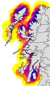
“Rafts and other wild fisheries groups have argued for years that many fish farms are too close to migratory fish rivers, increasing the risk that sea lice released from fish farms will infect wild salmon and sea trout.”
Interaction between wild and farmed salmon
Rafts has been responsible for the Scottish Government’s Managing Interactions Aquaculture Project (MIAP) on behalf of fishery trusts and boards since 2011. MIAP focused on interactions between salmon aquaculture with wild salmonids on Scotland’s west coast, from Argyll to West Sutherland and the Outer Hebrides.
The aim, the organisation says, is to identify areas that are particularly sensitive to wild salmon and sea trout and which the aquaculture industry should avoid if damage to wild stocks is to be minimised or avoided.
Brook said: “It should be of major concern to all those charged with managing and regulating salmon farms that the majority of existing farms are inappropriately sited from a wild fish perspective. Serious consideration should now be given to a selective relocation programme.”
Mr Brook added: “The development of the map was always intended as a means of influencing the planning process locally.
“Essentially it is an evidence-based approach to inform representations to planning proposals for new fish farm sites. Fishery trusts, fishery boards and others can use the map to improve protection of wild fish by identifying the highest risk places. No such tool has existed previously”.
Background
Formed in 2005, Rafts is an independent freshwater conservation charity representing Scotland’s national network of 25 rivers and fisheries trusts and boards.
Advertisement
Hide AdAdvertisement
Hide AdScott Landsburgh, chief executive of the Scottish Salmon Producers’ Organisation, said: “As stated by Rafts, the model announced today is still in its infancy.
“I look forward to seeing it develop in order to see if it becomes of value to the planning process as claimed.
“I am sure the Scottish Government will want to look closely at its development and will need to consult widely when it reaches a more developed stage, particularly as it has already made clear its support for the development of the farmed salmon industry.”