Slow Ways project shows how covid made us re-think urban environment


A thought experiment.... What would happen if you took a city with a population of around half a million people and told the residents that, for a period of several months, they should work from home where possible, they should only go out once a day for exercise, and they should travel no further than five miles outside the city boundary? How would you expect the character of the urban environment might change? And how might residents' attitudes to that environment evolve?
Of course, thanks to the pandemic this isn't a thought experiment but a description, albeit in very general terms, of what has been happening in Edinburgh on and off since March 2020. As a result, we don't have to guess at the answers, because we already know them. If people don't have to commute to work each day, then even our busiest roads become eerily quiet; birdsong becomes audible again; deer start popping up in areas of the city that have been too noisy for them for decades. And as for the way residents interact with their city? Well, a scientific answer to that question would require a complicated, large-scale survey and Final Words is a bit pushed for time this week, but I don't think it's too controversial to suggest that 1) rationing time outdoors has had the effect of increasing its perceived value and 2) preventing people from leaving the city has forced them to make the most of what's available, and in particular to seek out its green and blue spaces, its parks and woodlands, its waterways and beaches.
Advertisement
Hide AdAdvertisement
Hide AdEarlier this year, regular readers may remember, Charlie Peel of social enterprise Urban Good, working in collaboration with freelance consultant Rob Bushby, launched the Urban Nature Map of Edinburgh, which colour-coded the city in such a way that green space and blue space are highlighted, with the built environment relegated to the background. (An Urban Nature Map of Glasgow is also available.) Not only are these maps handy tools for people searching for a bit of green or blue space close to home, they also seemed to embody the way people were coming to reconceptualise their cities; and now there's further good news for those looking to expand their understanding of green-and-blue Edinburgh and – indeed – for the residents of towns and cities all over Scotland and the rest of the UK who might be feeling similarly inspired. After more than a year in development, an initiative called Slow Ways dreamed up by the geographer and explorer Dan Raven-Ellison and supported by Ordnance Survey, has launched its eagerly-anticipated website. The idea behind it is to get people walking between locations they might otherwise drive or take public transport to, using existing off-road paths, and the ultimate goal is to connect all of Great Britain’s towns and cities as well as thousands of villages.
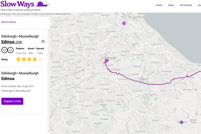
Last spring, a team of 700 volunteers plotted some 7,000 routes, which collectively stretch for over 100,000km, and these are all now available to view on the Slow Ways site. So, for example, if you wanted to get from Edinburgh Waverley Station to Musselburgh, there's a recommended route called "Edimus One" which (after a little necessary urban orienteering to begin with) takes you there on a largely car-free route, first via Holyrood Park and then following Niddrie Burn through Jewel Park and Magdalene Glen.
But this is only Phase One of the project. Now that the suggested routes are live online, Raven-Ellison is keen for people to try them out and – where possible – to suggest improvements.
"Working from their living rooms and kitchens, volunteers have done an incredible job of drafting the network," he says, “ but now we need to make sure it works on the ground... To do that, we need people to head out and walk all the proposed routes to check them."
In the case of the "Edimus One" route this checking process is already underway – the first reviewer gives the published route four stars out of five, but suggests that, rather than skirting around the edge of Holyrood Park, "it would make more sense for the route to go through the Innocent Railway Tunnel as it would be more direct and easier to follow as it is a well-signposted route." The Innocent Railway Tunnel is fine for bikes, but it’s a bit of a dull, dark slog for walkers, so perhaps the finished entry will suggest cyclists take the tunnel and walkers go via the park.
Either way, as Raven-Ellison says, the published routes are really starting points, to be tweaked and finnessed over time. Alread y, the Slow Ways website is a phenomenal resource – and, like the Urban Nature Maps of Edinburgh and Glasgow, a tangible manifestation of the way in which the pandemic forced us all to look at the world around us from a completely different perspective .
To explore the Slow Ways website, and to suggest improvements to the existing routes, visit https://beta.slowways.org/
A message from the Editor:
Thank you for reading this article. We're more reliant on your support than ever as the shift in consumer habits brought about by coronavirus impacts our advertisers.
If you haven't already, please consider supporting our trusted, fact-checked journalism by taking out a digital subscription at https://www.scotsman.com/subscriptions