Travel routes and landing places of Vikings in Scotland to be mapped like never before


The coastal entry points of the Norse settlers, and also the land routes where they dragged their boats to shorten journey times and avoid unnecessary dangers, will be examined on a scale never seen before.
Viking experts from University of Highlands and Islands and their academic counterparts in Germany will use a mixture of Viking place names, geophysical surveys and archaeological excavations to map the travel and communication routes used by Scandinavians in Scotland between 790 and 1350 AD.
Advertisement
Hide AdAdvertisement
Hide AdThe study will focus on sites primarily on the west coast, but a handful in Caithness and Sutherland will also be examined.

It is expected that hundreds of potential locations linked to Norse settlers will be identified, with a portion then to be researched in depth.
Professor Alexandra Sanmark, of the Institute of Northern Studies at the University of Highlands and Islands, who will lead the research project, said : “My previous work has been on Viking settlements of Scotland and what kind of society they were creating here compared to Scandinavia.
"There has always been a gap - and that was the travel.”
Vikings first landed in Shetland and Orkney Isles in the late 8th Century with further onward migration following as the islands became overpopulated.
The arrivals, first pillaging and plundering, became more peaceful over time with their culture and language starting to leave their trace on their new homeland.
Viking place names are of key interest to the research team and have the ability to unlock a “mental map” of routes into Scotland and landing places then used, Prof Sanmark said.
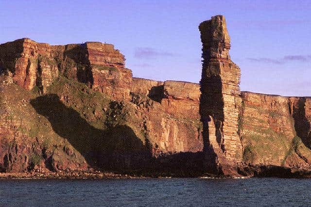
Orkney island of Hoy - the last land which separates Orkney from the Atlantic - derives it name from the Old Norse word ‘háey’, with Hoy translating as High Island.
Meanwhie, Lerwick translates as ‘muddy bay’ and Kirkwall as ‘church bay’.
Advertisement
Hide AdAdvertisement
Hide AdProf Sanmark said: “The place names tend to be quite descriptive. There is so much place name evidence and it is so important too. We can break them down into Old Norse and they can tell us so much
"We know there were also some descriptions for travel. One account of how to sail from Bergen to Greenland describes how to set off to the west, then north of Shetland which could be seen in clear weather and south of Iceland where there were birds and whales. It’s like a mental map and I think it would have been the same for those heading to Scotland, this idea that the journey is made by tying these key features together.”
As researchers piece together Viking movements, place names which derive from the Old Norse for harbour (hafn) will be of particular interest. Those which carry the element knörr (a type of ship), such as Knarston in Orkney, could reflect a mooring place for vessels.
“Gaelic place names, may of course contain Old Norse elements, so we will be looking at these too,” Prof Sanmark said.
The relationship between the sea and the land will also be examined, with the Vikings use of portages – narrow strips of land between waterways - also of key interest.
Language again will be a key guide to such locations, with Eday in Orkney translating from the Old Norse for Portage Island, for example.
It was places such as Eday that Viking boats, with their low keels, could sail right onto a beach and a large crew could drag their ship across land to shorten travel time and journey distance.
Professor Sanmark said there were many portages likely used by Vikings in Scotland.
Advertisement
Hide AdAdvertisement
Hide AdShe said: “Nobody has really looked at these before. The Viking boats were really, really light and they could be pulled across land really easily. The Vikings created short cuts. We know that when the Vikings were in Russia and coming down the rivers, hitting lots of rapids, they would get out the boat and walk.
"These boats were so light that they could be pulled for around a kilometre without much effort.”
Small ships were sometimes put on wooden poles and carried by the crew with larger vessels sometimes moved on rollers.

Research into Viking travel is due to begin in “earnest” in February with one of the first sites of interest being Loch na h-Airde on the Rubha an Dunain peninsula on Skye.
In 2009, archaeologists discovered early 12th Century boat timbers, a stone-built quay in the loch and a system to maintain a constant water level to allow boats, likely birlinns, to enter the sea at high tide.
It is believed the site, which has since been scheduled, served as a significant anchorage for the western seaboard with further remains of Norse and medieval vessels potentially lying in the loch.
Prof Sanmark will lead the project, with the team also including Dr Andrew Jennings, programme leader on on the MLitt Viking Studies at UHI, who has a special interest in Viking place names.
Dr Sven Kalmring of the Centre for Baltic and Scandinavian Archaeology at Schleswig and Dr Dennis Wilken of the University of Kiel will be joining the research team from Germany.
Advertisement
Hide AdAdvertisement
Hide AdDr Kalmring has long studied Viking Age harbours and written extensively on Hedeby on the east coast of the Jutland Peninsula, once an extremely important trading place in Viking Age Denmark.
He also builds equipment specifically to handle conditions presented by harbour sites. Meanwhile, Dr Wilken is an expert in geophysics.
The research is being funded by the Humanities from the Arts and Humanities Research Council (AHRC) and the German Research Council (DFG)