Battle to save anti-Jacobite fort from very modern threat


A major piece of work has been underway to protect the fort, which overlooks the Moray Firth and has been home to the British Army for more than 250 years, from rising sea levels and the risk of more frequent and more intense winter storms.
Every millimetre of the 66-acre military site has been measured and captured to build the most accurate picture of the fort – and the surrounding coastal landscape – as it stands in 2020.
Advertisement
Hide AdAdvertisement
Hide AdMore than 1,000 laser images have been captured with more than 26 billion data points – or measurements – taken.
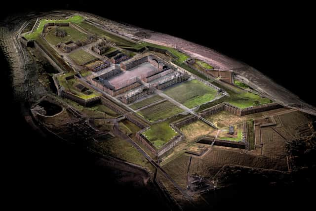
These have been used to create an incredible 3D model of the site and a data baseline which will help monitor changes in the building’s structure, the surrounding environment and the risk that climate change poses to the Grade A listed complex.
Dr Lyn Wilson, Digital Documentation Manager at Historic Environment Scotland said, the scan of Fort George was a ‘milestone’ for the organisation given the sheer scale of the site.
It was completed as part of HES’s Rae Project, the first in the world to digitally document historic assets in 3D.
Dr Wilson said: “Fort George is one of the sites that we have been building up as it is such a massive undertaking. Now that it is completed, it’s a significant milestone for us given its geography is the largest and most complex.
"The Fort George scan is very much a milestone for us as it is such a huge site and has taken a long time to complete. The data that we have collected on the site will be used as baseline information for when we go back and record again, allowing us to monitor coastal erosion around the site.”
Staff spent three weeks in the field gathering data, with several months spent processing the data set that helped to build the model, which will go online shortly. It means the building can be explored by people from all over the world, from experts to members of the public, without having to visit the site in person.
Dr Wilson said: “Now we have this data, it gives us a baseline condition of the buildings and fortifications, as well as the current state of the coastline. We will go back every two or three years to compare the data and that will help us to monitor coastal erosion around Fort George.”
Advertisement
Hide AdAdvertisement
Hide AdSimilar 3D scanning work has been carried out at Skara Brae on Orkney
At Fort George, the 1,000 laser scans were added to by a series of overlapping photographs as well as drone footage
The fort, which was designed by Lieutenant-General William Skinner and built by the Adam family of architects, took 22 years to build.
Byt the time it was finished, the Jacobite threat had subsided but the fort has served the British Army for almost 250 years since.