The secret silk WWII escape plans of an Edinburgh map maker


The silk maps were key to operations of MI9, a little known intelligence branch set up during World War Two to provide escape and evasion support to those held in enemy territory.
Famed Edinburgh map maker and geographer John Ian Bartholomew became central to the creation and success of the branch with his role in supporting MI9 remaining a secret all his life.

Advertisement
Hide AdBartholomew was the first cartographer in the country to share his maps with MI9 and worked directly with Charles Clayton Hutton, the eccentric technical officer in charge of escape tools who had no military experience but a fascination for magic and illusion.
Hutton met with Bartholomew in Edinburgh after hearing of his expertise from a London map publisher with the two striking up a close working relationship.
The Scot gave the boffin-ish government employee, who once laid down a challenge to Harry Houdini, lessons in cartography and supplied him with 40 of his small scale maps of Europe, the Middle East and North Africa.
More than 300,000 copies of these were made to assist the escape and evasion of the enemy.
Historian Barbara Bond, who examined the work of MI9 in her book Great Escapes, said Bartholomew’s maps became the “critical ingredient” in MI9’s operation.
Ms Bond, who has been invited to speak on the maps by the Royal Scottish Geographical Society in Glasgow this week, said: “It was this collection of Bartholomew maps which provided the back bone of the escape and evasion programme which MI9 produced.
Advertisement
Hide Ad“I don’t think it is an overstatement to say Bartholomew’s role was crucial. Bartholomew got Hutton, who didn’t have a clue about maps, up and running.”
Bartholomew was a decorated Gordon Highlander offcier who was awarded the Military Cross at Ypres during World War One.
Advertisement
Hide AdMs Bond, a former maps expert at the Military of Defence, added: “Bartholomew knew this work was important and I think what was also significant is that three of Bartholomew’s sons saw active service during World War Two.
“While they had not gone to war by time Hutton visited Edinburgh, I think Bartholomew knew they would go.
“Bartholomew also waived all copyright fees. That is the interesting thing. When you consider more than 300,000 copies of his maps were made, it was an incredibly generous gesture.”
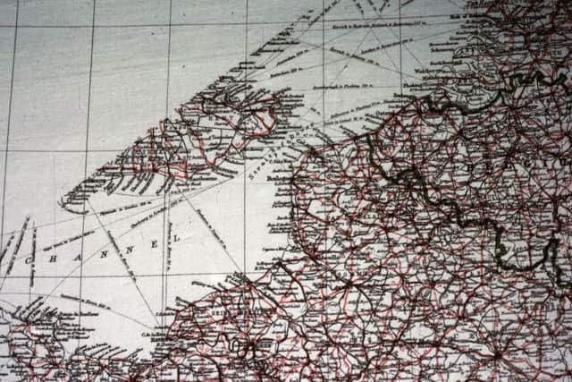
Bartholomew’s maps were printed on silk, rayon and a lightweight mulberry leaf pulp.
Silk was the favoured material as the map could be hidden away in small places or stitched in the lining of a serviceman’s jacket where it did not rustle or deteriorate on contact with water likes its paper equivalent.
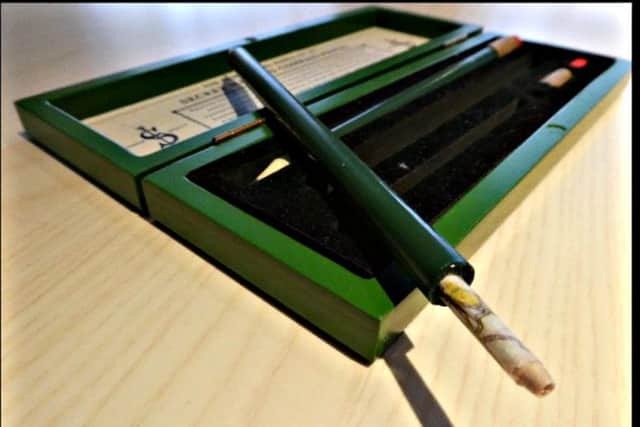
The highly durable documents were smuggled into Prisoner of War camps using increasingly ingenious ways masterminded by Hutton, from hollowed out pencils to gramophone records which had to be broken open to retrieve the maps. This particular method of carrying the contraband became known as Operation Smash Hits.
Advertisement
Hide AdAround 1,300 gramophone records produced by Columbia were used to transport the maps, each containing four or five secret documents sealed in the laminated layers of each pressing.
Hutton using the works of Beethhoven and Wagner to dispatch the documents given the work of any Jewish composer would be immediately confiscated by German guards or censors, Bond said.
Advertisement
Hide AdPlaying cards were also devised with the maps sandwiched between the back and the pip side with the cards coming apart when dropped in water. Each pack of cards contained a map in 48 pieces with the Joker usually containing the key.
Some years ago, a hand drawn copy of a smuggled Bartholomew map was found. The faded paper document showed a section of the Swiss border traced from one of the first Edinburgh-made maps to be shared with MI9.
Ms Bond said soldiers spent much time and energy copying maps from the originals that MI9 were able to smuggle into camp, given that multiple copies were required for multiple escape plans.
“It demonstrates the extent to which the maps could, and did, provide a veritable passport to freedom for some prisoners of war,” she said.
John Ian Bartholomew never discussed his work with MI9 with his staff also unaware of his activities.
Ms Bond added: “Some years back, his son John Christoper told me that he had no idea of his father’s involvement with MI9. It was a very well kept secret.”
Barbara Bond will deliver the Royal Scottish Geographical Society talk on MI9 and Bartholomew’s Maps at Waterstones, 153-157 Sauchiehall Street, Glasgow, on Wednesday March 31 at 7.30pm.