The Scottish tidal islands you can walk to without a ferry


But some of the country’s most unspoilt isles can be reached by simply putting one foot in front of the other.
There are 17 tidal islands which can be reached from the Scottish mainland, and at least a further 20 around the Outer Hebrides, Orkney and Shetland. They have been colonised by Vikings, used as military bases in wartime and even become places of religious pilgrimage.
Advertisement
Hide AdSome examples – such as Edinburgh’s Cramond Island – are relatively well-known and easily reachable by causeway. Others can be more challenging, with fast rising tides and sinking sand to contend with.
For author Peter Caton, the rewards of exploring a remote place few others will ever see outweigh the dangers. He visited each of the 43 tidal islands accessible from the UK mainland for his book No Boat Required.
While some islands can be reached once or twice a year during abnormally low tides, Caton visited only islands that can be reached “with dry feet at least once a month”.
“The appeal of tidal islands is they are always different,” he said. “Some of them are nice easy walks which feel like extensions of the mainland, but then the tide comes in and they suddenly become their own world. I’m not a particularly good sailor, so visiting tidal islands for me was a good way of exploring without the need for a boat.”
Caton advises that planning ahead is crucial – if you don’t know tide times, you could find yourself stuck. It’s an issue that residents near Cramond Island know only too well.
Lifeboats are often called out to collect stranded visitors during the summer months, with one community councillor demanding that those who call the emergency services should be fined to pay for the cost of their rescue. In 2013, John Dods said: “It’s just too easy for these flaming idiots to get stuck and call out the lifeboats.”
Advertisement
Hide AdCaton was unimpressed with Cramond when he visited, noting that the island was covered in rubbish and assorted debris from all-night parties that often take place in the summer months.
Among his favourites was Hestan, a small island at the southern foot of the River Urr estuary in the Solway Firth. Official tourist guides discourage people walking across the bay due to fast tides, but after taking local advice on the best route, he made it across at the second attempt.
Advertisement
Hide Ad“It was quite a challenge,” he added. “It is in a very remote spot and involves a bit of a climb. But that’s part of the enjoyment.”
ISLANDS YOU CAN WALK TO
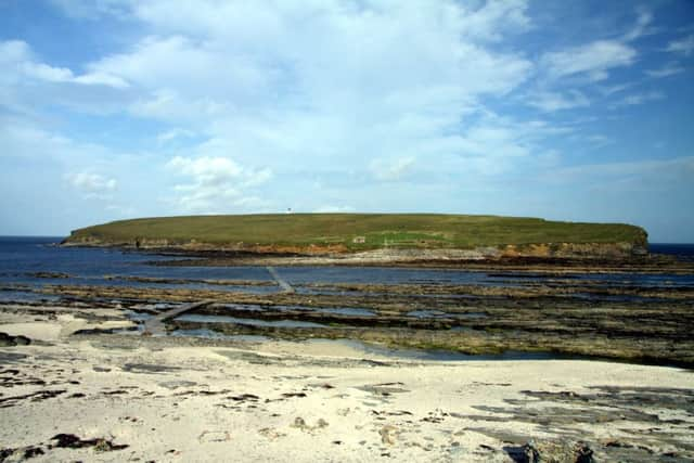
Brough of Birsay, Orkney
An uninhabited tidal island off the north-west coast of mainland Orkney, the Brough of Birsay is accessible on foot at low tide via a largely natural causeway. In the seventh and eighth centuries it was home to a significant Pictish fortress, but by the ninth century the Picts had been displaced by Norsemen. The extensive remains of an excavated Norse settlement and church overlay the earlier Pictish settlement. Before Kirkwall became the centre of power in the 12th century, Birsay was the seat of the rulers of Orkney.
Cramond, Edinburgh
A short bus journey from the centre of the capital, Cramond is a popular tourist destination all year round. A causeway takes you straight from the village to the island. There’s much to explore when you get there, with numerous ruins dotted around from Cramond’s past life as part of the Forth’s upper defences during the two World Wars. With tide times prominently displayed, there is little excuse for those who become stranded.
Danna, Argyll
Danna is an inhabited tidal island connected to the mainland by a stone causeway at the southern end of the Tayvallich peninsula, which separates Loch Sween from the Sound of Jura. Mainly farmland, the island has a settled population of around five. To the south of Dana are the McCormaig Isles, which can only be reached by boat. The largest, Eilean Mor, was bequeathed to the Scottish National Party in 1978, and has been managed since 2000 by a charitable trust.
Davaar, Kintyre
Davaar Island, near Campbeltown, is linked to the mainland by a natural shingle causeway at low tide called the Dhorlin. The island is known for its Stevenson-designed lighthouse and its seven caves - one of which contains a life size cave painting depicting the crucifixion, painted in 1887 by local artist Archibald MacKinnon following a vision.