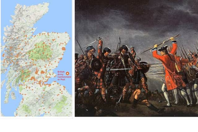
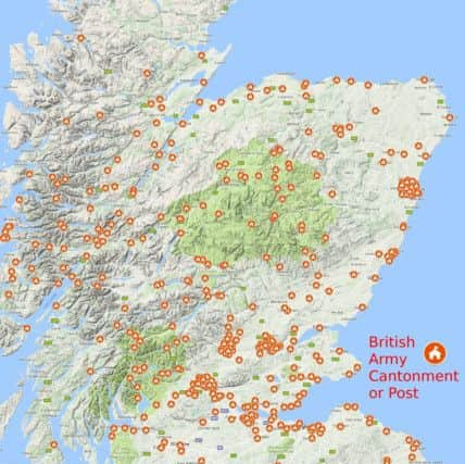
Map shows 400 British Army camps in Scotland after Culloden
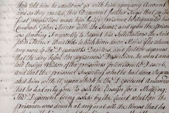
The document has been drawn up following analysis of 270-year-old handwritten cantonment records held in the library at Edinburgh Castle.
More than 11,600 British Army soldiers remained in Scotland following Culloden to suppress the uprising and its supporters, according to research by Stennis Historical Society, which is based in Edinburgh.

Advertisement
Hide AdSoldiers were also charged with enforcing laws designed to dismantle the Highland way of life, according to the papers.
Army posts were to be “occupied by the regular forces in the Highlands, to put the Laws in Execution for disarming the Highlanders, suppressing the Dress and for preventing Depredations,” a passage in the cantonment records said.
The map shows how the camps, which were recorded between 1746 and 1755, stretched from Orkney in the Northern Isles to the Scottish Borders.
Author and historian Stuart McHardy, who encouraged the society to research the papers, said he had been “blown away” by the results of the study.
He said: “I came across the document around 20 years ago and there is only one handwritten copy. It is a unique thing.
“What is makes clear is that Scotland was under blanket British Army occupation for the seven to 10 years after Culloden.
Advertisement
Hide Ad“The standard story is that after Culloden the Jacobite cause was kaput. It wasn’t. There is new evidence coming to light that there was a definite readiness to rise again.
“The reason that is didn’t go ahead was that they didn’t get the go ahead from Charlie (Prince Charles Edward Stuart) or his father. They just weren’t interested in Scotland any more.”
Advertisement
Hide AdMr McHardy pointed to the 1752 Elibank Plot to kill or kidnap King George II and St James’s Palace and restore the Stuart line to the British throne.
The plan never went ahead given the doubts of some of the key players but Mr McHardy said the plan showed that Jacobitisim endured for some.
Varying vastly in size, the camp at Edinburgh housed a battalion, which was usually between 780 and 1180 men, with records showing multiple, smaller clusters of forces through the rest of the country.
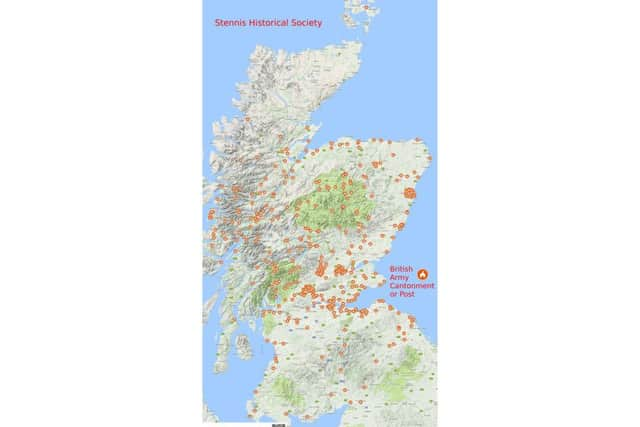
A post at Achtriachtan in Glencoe, for example, was manned by just one corporal and five privates.
Similar camps are listed at locations including Knoydart, Arisaig, Glen Spean and Loch Leven with soldiers listed in Perthshire, Aberdeen and the surrounding Shire, the Moray Coast, The Cairngorms and down through the Central Belt to Dumfries and Galloway and the Borders.
David Kennedy, society secretary, led the production of the map.
Advertisement
Hide AdHe said: “We are very pleased that we have managed to get this information out of these records. This stuff has never been published before.
“I was personally surprised by the figures. I think most of us in the society were.”
Advertisement
Hide AdThe society is further researching ‘Situation Reports’ held in the castle library, which detail day to day movements and activities of soldiers.
They include capturing British Army deserters and Jacobite rebels, who are usually described as thieves, or chasing Catholic Priests for holding Mass.
Translating place names listed in the records had, at times, been challenging given they were written down in phonetic Gaelic, Mr Kennedy said.
He added: “I speak Gaelic and I was able to work out how a non-Gaelic speaker might write down a Gaelic place name. Without that knowledge of the language, I don’t think we could have gone to the extent we did with our research.”
The research has attracted interest from academics of history and archaeology given it sheds new light on mid-18th Century Scotland.
Professor Murray Pittock, historian and author of Glasgow University, who has written extensively on Culloden and the Jacobites, has shown interest in the map. He is currently writing a book on the occupation of Scotland following 1746.
Advertisement
Hide AdHe posted on Twitter: “The occupation of 1746-56 did not just affect the ‘Highlands’. If anyone still requires convincing of the Myth of the Jacobite Clans, just look at the map.”
Stennis Historical Society will exhibit its finding during the Edinburgh Fringe Festival at the Edinburgh Yes Hub 31 Lasswade Rd, Edinburgh EH16, from August 6 to 27.