100 Weeks of Scotland: West Fife


Week Sixty Three
I wanted to visit the country west of Dunfermline, north of the Forth river, east of Alloa, and south of the Ochil hills.
There is a great diversity in this area of West Fife. There is the small harbour villages of Culross and Limekilns, reminiscent of the fishing villages of the East Neuk of Fife, the vast behemoth that is the coal powered Longannet power station, the old mining communities of Steelend and Comrie, the vast Devilla forest, and in the north the hill side towns reminiscent of ones I have seen deep in the magical mountains of Mourne in Ireland.
Leave maps behind
Advertisement
Hide AdI set out with no map, no satnav, just a rough idea of the area. I knew that if I kept away the main roads and stuck to the back roads I wouldn’t be disappointed. I can’t recommend highly enough heading off somewhere and leaving all the maps behind. Coming to a junction and just taking the road that looks the nicest seems such a tiny thing, but is a delicious pleasure.
So it begins. I negotiate the endless dead-ends of the dockyard at Rosyth and before long find myself descending a steep hill into the coastal village of Limekilns, whose history stretches back to the fourteenth century. As it’s name suggests lime was certainly burnt here in times past although it probably relied more on fishing and trade, and as the northern terminus of the ferry across the river to Bo’ness.
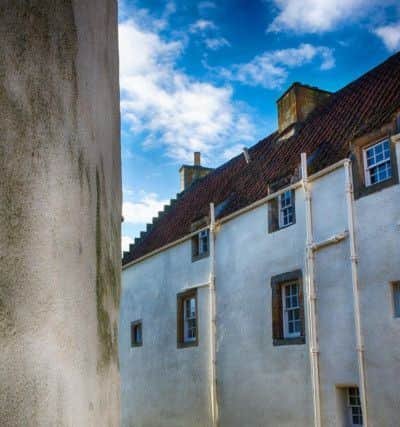
Culross
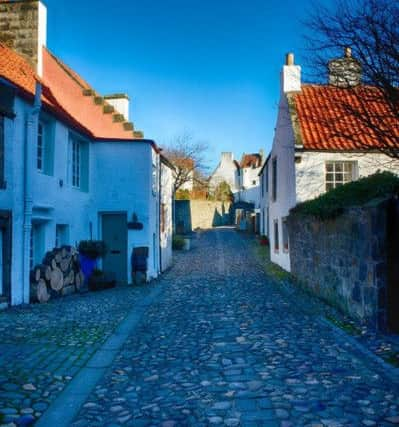
On through the village of Charlestown and I head inland before looping back to the coast and the truly wonderful gem that is Culross. I had heard often of Culross and had been told many times that I should visit but this was the first time I had. Although tiny, Culross is instantly captivating and its narrow medieval streets, beautifully car-free, seem to have changed little in its long history. I hadn’t really intended to spend too long here but I was instantly hooked and didn’t really want to leave.
The village is believed to date from the 6th century and was founded by St Serf (the foster father of St Mungo, patron saint and founder of Glasgow). Incredibly it was here, in 1575, that the first mine in the world to extend under the sea was constructed. It produced coal for half a century before it was destroyed in a storm and its ruins are visible yet at low tide. Many of the buildings boast red roof tiles - a direct result of the village’s trade with Holland and the seaports of the Hanseatic League (they were used as ships ballast).
Devilla Forest, Longannet
Still, all things must pass, and Culross soon was no more than a half glimpsed memory in my rear-view mirror as I carried on west, past hills of coal that are endlessly consumed by the mighty power station at Longannet (once the largest in Europe) before, at the twin bridges that cross the river at Kincardine I turn northeast and am soon skirting the southern fringes of Devilla forest where I pull in and stop (the dog has been glaring at me from the boot of the car for some time).
Walking beneath the Scots Pines as they leap effortlessly skyward it is hard to believe that most of this huge area of woodland only dates from the 1950s. Before then it was rough and unforgiving moorland; it was home to witches, it saw King Duncan and his lieutenants Macbeth and Banquo defeated in battle by the Danes, and was the setting for clandestine and highly dangerous religious meetings in the time of the Covenanters.
Advertisement
Hide AdNorth now, and with the sun beginning to sink toward the west I make my way through towns that cling to the southern skirts of the Ochils. Up into the hills past isolated buildings that once barrage balloons rose up from during the war, past the racetrack at Knockhill before again heading west and, from on high, l look out across the western Ochils, painted by the light of a dying sun, and the low floodplain of the Forth valley.
From here I am told you can almost see to Loch Lomond far away past Stirling and the Kippen straight. With the light fading fast I turn for home and leave this still mostly undiscovered country behind. For now, at least.
Advertisement
Hide Ad• Alan McCredie began the ‘100 weeks of Scotland’ website in October last year, and it will conclude in Autumn 2014. McCredie’s goal is to chronicle two years of Scottish life in the run-up to the independence referendum.
McCredie says ‘one hundred weeks...’ is intended to show all sides of the country over the next two years. On the site, he says: “Whatever the result of the vote Scotland will be a different country afterward. These images will show a snapshot of the country in the run up to the referendum.
“The photos will be of all aspects of Scottish culture - politics, art, social issues, sport and anything else that catches the eye.”
Follow the project at 100weeksofscotland.com. You can also follow Alan on Twitter.
All pictures (c) Alan McCredie/ 100 weeks of Scotland