10 of Scotland's best bothies


Best for coast and beach: Glengarrisdale
Location Grid Ref NR 664 968, 7m, OS Landranger Map 61. On the far north-west coast of Jura, 25 miles north of Craighouse, the only village on the island.
Walk in time 2 to 3 hours.
Distance 4 miles.
Terrain Challenging – route follows a faint path and open ground.
Advertisement
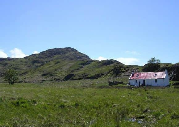
Hide AdGlengarrisdale, sheltered in the secluded bay from which it takes its name, lies on the far NW coast of Jura, a magnetic location with views out to Mull, Scarba and the Garvellachs.
The bothy is one of only four buildings along the entire 50 miles of Jura’s western seaboard. Although now a very remote outpost, this valley once supported a large community and was the site of Aros Castle, stronghold of the Macleans, a clan loyal to Bonnie Prince Charlie and the Stuarts. Maclean’s Skull, possibly a relic of a battle between the Macleans and the Campbells, once lay in a cave here, but was spirited away in 1976.
Best for families: Peanmeanach
Location Grid Ref NN 847927, 389m, OS Landranger Maps 43/35. On the south coast of the Arnish Peninsula, south of the A830 Fort William to Mallaig road and the Western Highland railway line.
Walk in time 1 to 1½ hours.
Distance 3½ miles.
Terrain Straightforward – stalkers’ path all the way.
It is easy to see why Peanmeanach holds such a special attraction to regular bothy goers, including many families. The combination of easy accessibility by road or rail, straightforward walk in, and wonderful location – above a raised beach on a rugged headland – make it a perfect place to take even those who wouldn’t normally see themselves as hardy adventurers. Admire the views over to Ardnamurchan and Eigg, hunt out mussels at low tide, or wander along the coast to a little gem of a beach, known locally as the Singing Sands. It’s also popular with kayakers heading over the Sound of Arasaig from Moidart, or round the coast from Lochailort.
Best for wildlife: Ruigh Aiteachain
Location Grid Ref NN 847927, 389m, OS Landranger Maps 43/35. In the heart of Glen Feshie, 15 miles south of Aviemore.
Walk in time 1 to 1½ hours.
Distance 3½ miles.
Terrain Easy – track all the way.
Hidden between stands of ancient Caledonian pines close to the meandering River Feshie, Ruigh Aiteachain ‘the shieling of the juniper bush’ is one of the best-kept bothies in Scotland. Glen Feshie has a particular association with the 19th century English landscape painter Sir Edwin Landseer, whose most famous work, the instantly recognisable Monarch of the Glen was inspired by the time he spent here. The bothy is presently undergoing extensive renovation work under the guidance of new owner Anders Povlsen.
Most romantic: An Cladach
Advertisement
Hide AdLocation Grid Ref NR 439 623, OS Landranger Map 60. On the eastern coast of the Islay, four and a half miles south of Port Arkaig.
Walk in time From Lossit farm 2 to 2½ hours.
Distance 3½ miles.
Terrain Straightforward – track and faint path along the shore.
Advertisement
Hide AdAn Cladach is one of the sweetest bothies you could ever wish to visit. Perched almost within touching distance of the shore S of Rubh’ a’ Chladiach, ‘the Point of the Stony Beach’, it offers splendid views of Jura, and the Kintyre peninsula. The cosy interior boasts a small library, board games, and even a pair of binoculars. The leeward coast of Islay is surprisingly untouched and you often see otters on the beach.
Best for solitude : Uags
Location Grid Ref NG 724 349, 23m, OS Landranger Map 24. 10 miles south of Applecross Village.
Walk in time 1 to 1½ hours.
Distance 2½ miles.
Terrain Straightforward – faint path over moorland.
Set above a little rocky raised beach at the south end of the Applecross peninsula, Uags Bothy is a magical place where you quickly escape the bustle of modern life. Walking in along a wild unspoilt stretch of coastline on a clear day, there are wonderful views across the Inner Sound to Scalpay, Raasay and Skye, with the Cuillin Ridge just visible on the skyline. Although today an isolated spot, Uags (Old Norse for “bay”) was once part of a small crofting township, and the supporting walls and gable ends of a couple of homesteads are clearly visible nearby.
Best for history: Ben Alder Cottage or McCook’s Cottage
Location Grid Ref NN 499 680, 373m, OS Landranger Map 42. Tucked away beneath the shadow of the Ben Alder massif, above a small bay on the shores of Loch Ericht, in the vast wilderness between Dalwhinnie and Rannoch.
Walk in time From Loch Rannoch 2½ to 3½ hours.
Distance 7½ miles.
Terrain Challenging – track and faint path.
A trip to Ben Alder Cottage (aka McCook’s Cottage) is not for the fainthearted, but there is a tremendous sense of achievement when you arrive. Among the hill-walking fraternity, it is one of the most well-known bothies in Scotland, not least because it is reputedly haunted. A jumble of rocks above the bothy, known as Cluny’s Cage, was one of the places Bonnie Prince Charlie allegedly took refuge after the Battle of Culloden.
Best for spectacular scenery: Shenavall
Location Grid Ref NH 066 810, 128m, OS Landranger Map 19. Found in the shadow of An Tellach, south of the A832 ‘Destitution Road’ between Gairloch and Loch Broom.
Walk in time From Dundonnell 1½ to 2½ hours.
Distance 4½ miles.
Terrain Straightforward – track and boggy path.
Advertisement
Hide AdA flagship MBA bothy, a visit to Shenavall is the perfect introduction to the delights of bothying. Spectacularly located on the edge of the Fisherfield Forest, in an area know as ‘the Great Wilderness’, it has been a magnet for Munro baggers and walkers over the decades. Among its distinguished guests have been renowned author and mountaineer WH Murray and HRH Prince Charles, who hiked out here while a pupil at Gordonstoun.
Best for Munros: Lairig Leacach
Location Grid Ref NN 283 736, 467m, OS Landranger Map 41. Lies south of the cross coutry route from Fort William to Newtonmore on the A86 and West Highland Railway line.
Walk in time From above Roy Bridge 1½ to 2 hours.
Distance 4 miles.
Terrain Straightforward, track – steep in places.
Advertisement
Hide AdLairig Leacach, the ‘pass of the flagstones’ is a very handy place to know. Located in a tight V-shaped cleft between the Grey Corries and the Easians, on the high point an old
droving road that used to run from Great Glen to the Kingshouse, the bothy is surrounded by high peaks that can’t help but whet your appetite. The bothy is quite small and very
popular at weekends, so it’s best to bring a tent just in case you can’t squeeze in.
Most wild and remote: Maol Bhuidhe
Location Grid Ref NH 052 360, 261m, OS Landranger Map 25. The most remote bothy maintained by the MBA, lost in the lonely territory between Loch Mullardoch, Loch Monar and Glen Carron.
Walk in time 4 to 5 hours.
Distance Over 10 miles.
Terrain Challenging – The bothy can be approached from the south, along a stretch of the Cape Wrath Trail starting from Sheil Bridge, west from Attadale on the southern side of Loch
Carron, or from the north starting at Achnashellach. Each route has sections which cross rough ground.
Advertisement
Hide AdThere is a certain mystical quality associated with Maol Bhuidhe. The sight of its distinctive whitewashed exterior has brought relief to many a weary traveller. A place of pilgrimage for many bothy enthusiasts, the challenge of heading out here is rewarded by the tranquillity experienced on your arrival.
My favourite: Staoineag
Location Grid Ref NN 296 678, 293m, OS Landranger Map 41. Sits in the surprisingly remote sweep of moorland between Fort William and the West Highland Railway line north of Rannoch Moor.
Walk in time 2½ to 3 hours.
Distance 5 miles.
Terrain Straightforward – track and riverside path.
Advertisement
Hide AdStaoineag is a special place. Elevated on a rocky pinnacle above the meandering Abhainn Rath, this large welcoming bothy is most accessible by train, a characteristic that widens
its appeal. As well as archetypal outdoor enthusiasts, it attracts those without a car who are eager to enjoy a slice of wilderness. I’ve visited Staoineag over half a dozen times, and always taken home happy memories.