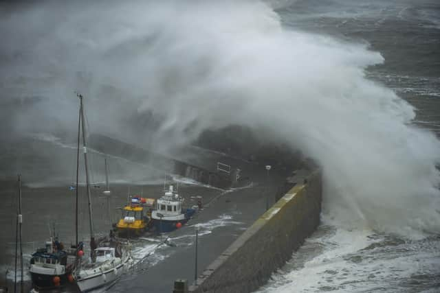
Storms Scotland: Will we see more named storms in Scotland? Why the outlook is turbulent in wake of Storm Isha and Jocelyn, amid climate change
After Isha and Jocelyn, the count is now only one short of the highest total number recorded since the tradition of naming storms began in 2015. There are seven more months left before the list resets.
Storms are named when they are expected to cause ‘medium’ or ‘high’ impacts in the UK, Ireland or the Netherlands. Each season runs from September 1 to the end of August the following year, with a new alphabetical list of names released annually at the start of the period.
Advertisement
Hide AdAdvertisement
Hide AdThe idea behind the convention is to raise awareness of severe weather and help people to prepare, so the impacts can be minimised. And if the chat on the street is anything to go by, it seems to work.
So why have we already seen ten named storms in the UK less than halfway through the season? Is this further evidence of the way climate change is affecting the planet?
It’s not quite that simple, according to meteorologists.
The effects of global warming, caused by increasing concentrations of atmospheric greenhouse gases from human activities, include rising sea level, melting ice caps, and more frequent and extreme weather events such as heatwaves, droughts and floods. But the effects on wind is not so clear, despite the current, seemingly relentless, succession of gales.

Firstly, since storm-naming began here less than a decade ago, there is not enough information available in this dataset to confirm a trend.
Not only that, the annual totals over this time have been variable – ranging from 11 named storms in 2015/16 to just two in 2022/23, with a mixture of five, six and eight in the years in between.
And the UK as a whole has a long and turbulent track record of major hoolies, from the Bristol Channel floods of 1607 and the deadly 1703 storm – arguably the worst ever, killing several thousand people – to the Eyemouth Disaster in 1881 and the Great Blizzard in 1891.
More recently were the North Sea Flood in 1953, the Great Storm of 1987, the 1990 Burns Day storm and the unprecedented floods of 2000.
Wind storms in the UK are usually caused by disturbances in an active jet stream – a band of strong winds high up in the atmosphere, which create and ‘steer’ low-pressure weather systems around the globe – over the Atlantic, directed towards north-west Europe.
Advertisement
Hide AdAdvertisement
Hide AdA jet stream forms at the point where chilly polar air from the north meets warmer tropical air from the south and is usually strongest when the difference in the temperatures is biggest – generally in autumn and winter. Fortification of the jet can cause the polar front to become unbalanced, which allows large disturbances in the form of vortices or cyclones to form, bringing stronger winds and heavier rain.
It is true that most projections indicate winter wind storms will increase slightly in number and intensity over the UK as a consequence of warming. However, Met Office experts say there is “medium rather than high confidence” in this scenario because “some climate models indicate differently”.
Even looking at longer-term Met Office climate statistics, it remains difficult to identify patterns in the number and severity of wind events in the UK.
Apparently the position and dimensions of the island we call home have a big part to play in the kind of weather received, although rising temperatures also have an influence.
“The UK has a history of impactful storms stretching back hundreds of years, long before the introduction of named storms in 2015,” said Dr Amy Doherty, science manager of the National Climate Information Centre at the Met Office.
“One thing that is clear from observations is that there’s big variability year to year in the number and intensity of storms that impact the UK.
“This large variability is related to the UK’s location at the edge of continental Europe and relatively small geographic size, so small changes in the position of the jet stream – which puts us in the path of low-pressure systems – can make a profound difference in the weather we receive.
“This large variability means that we have to be particularly cautious when analysing the data. In our observational records, it’s hard to detect any trend one way or the other in terms of number and intensity of low-pressure systems that cross the UK.
Advertisement
Hide AdAdvertisement
Hide Ad“While our climate overall is getting wetter, there are no compelling trends in increasing storminess in recent decades.
“Recent stormy seasons – such as that of 2013-14, before the storm naming system was introduced – clearly illustrate the fundamental problem with drawing conclusions from a simple count of the number of named storms.”
Met Office meteorologist and presenter Annie Shuttleworth explains why there has been such wild weather in recent months.
“While we have had some drier and calmer interludes, the stormy nature of the UK’s autumn and winter so far is chiefly dictated by the position and strength of the jet stream, which is a column of air high up in the atmosphere,” she said.
“The jet stream greatly influences the weather we experience in the UK and during recent months this has largely been directed towards the UK and Ireland, helping to deepen low-pressure systems. These systems have been directed towards the UK and have eventually become named storms due to the strong winds and heavy rain they bring.”
So is the high number of storms this season an anomaly or can we expect more of the same?
Annual variability in the frequency and intensity of storms will “continue to be a major factor in the future climate”, according to the weather service, but “we can be confident that the coastal impacts of wind storms, from storm surges and high waves, will worsen as the sea level rises”.
Comments
Want to join the conversation? Please or to comment on this article.