Scotland weather: Warnings of winds up to 70mph as Storm Kathleen rolls in

Weather warnings are in place this weekend for winds of up to 70mph as Storm Kathleen rolls in, while the country will also be enjoying relatively balmy April temperatures.
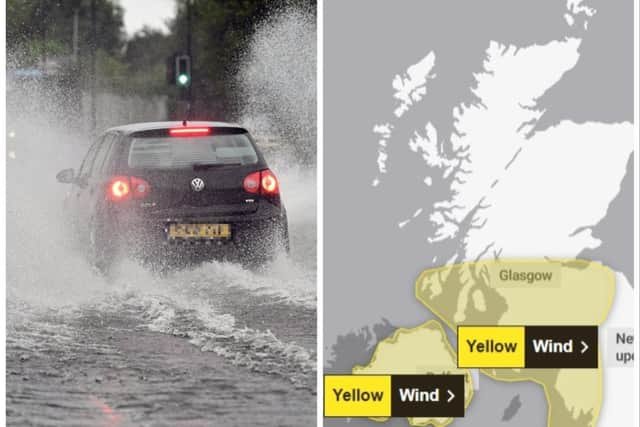
Travel disruption was expected as heavy downpours hit central Scotland on Friday, with warnings of 15-25mm of rain. Part of Scotland also saw snow fall on Friday warning, and a yellow warning had covered Tayside & Fife, Grampian, Highlands & Eilean Siar and Strathclyde until 9am.
Advertisement
Hide AdAdvertisement
Hide AdThe Met Office has also issued a yellow weather warning for wind with a deep area of low pressure in western areas, including parts of Scotland and Wales, and the north-west and south-west of England from 8am to 10pm on Saturday.

Met Office meteorologist Greg Dewhurst said that winds could reach speeds of between 60-70mph around western coastal areas.
“Winds pick up further through Friday evening, overnight into Saturday, where as we start Saturday morning we’ll see widely across the country gusts of 30-40mph,” he said.
“In western parts of the UK, inland, we could see gusts of 40 to 50mph and then around the western coast of the UK we could see gusts of sort of 60-70mph.”
Storm Kathleen, named by the Irish Meteorological Service Met Eireann, is the 11th named storm in eight months.
It is only the second time in a UK storm season that the letter K has been reached in the alphabet.
The Met Office has warned that stronger gusts are more likely during Storm Kathleen in an update to its weather warning.
The forecaster issued a yellow weather warning for wind in western areas of the UK, including Northern Ireland, parts of Scotland and Wales, and the north-west and south-west of England from 8am to 10pm on Saturday.
Advertisement
Hide AdAdvertisement
Hide AdOn Friday the Met Office said in its update: “Stronger gusts are now expected across some parts of the warning area, with likelihood also increased.”
It warned of injuries and danger to life from “large waves and beach material being thrown on to sea fronts, coastal roads and properties”, adding “road, rail, air and ferry services may be affected, with longer journey times and cancellations possible”.
There could also be power cuts and mobile phone coverage could be affected.
Wet and windy conditions are forecast to arrive on Friday, heading into Saturday, as Storm Kathleen rolls in.
Southerly winds are expected to gust quite widely to 50-60mph on Saturday, while some exposed spots, particularly in Northern Ireland, will see gusts to 70mph with large waves also likely.
Met Office meteorologist Greg Dewhurst said: “Winds pick up further through Friday evening, overnight into Saturday, where as we start Saturday morning we’ll see widely across the country gusts of 30-40mph.
“In western parts of the UK, inland, we could see gusts of 40 to 50mph and then around the western coast of the UK we could see gusts of 60-70mph.”
Despite the rain, there will be some warm spells of sunshine in south-eastern parts of England, with temperatures reaching up to 18C.
Advertisement
Hide AdAdvertisement
Hide AdA yellow warning for snow had been in place on Friday in Scotland from the early hours through to 9am covering central, Tayside & Fife, Grampian, Highlands and Eilean Siar and Strathclyde.
Storm Kathleen, named by the Irish meteorological service Met Eireann, is the 11th named storm in eight months.
It is only the second time in a UK storm season that the letter K has been reached in the alphabet.
Comments
Want to join the conversation? Please or to comment on this article.