'˜Incredible' bird's-eye view lifts the lid on 19th century Auld Reekie
This article contains affiliate links. We may earn a small commission on items purchased through this article, but that does not affect our editorial judgement.


Produced almost 4 decades before the first aeroplane took to the skies, the tremendous scale and intricate level of detail of this bird’s-eye view of Edinburgh, property of the National Library of Scotland, is truly mind-blowing.
The view, published on 18 July 1868 as a supplement in the Illustrated London News includes the entirety of central Edinburgh looking south to the Pentland Hills, as seen from a fixed point high above the city.
Advertisement
Hide AdAdvertisement
Hide AdRather fascinatingly, recognisable landmarks throughout the city such as the Caledonian Hotel and the Balmoral have yet to be built allowing us to see in great detail what existed there before.
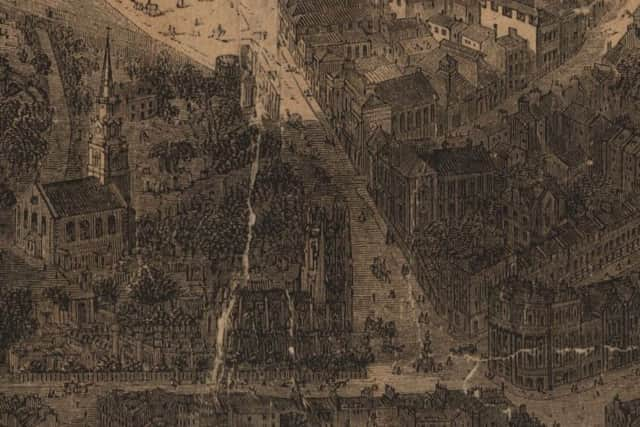
The map was initially hand-drawn by renowned architectural draftsman Thomas Sulman, a specialist in his field who had created similar views of London, Glasgow, Oxford and New York. Many of Sulman’s views were produced to fold-out up to an incredible six feet in length.
Chris Fleet, Map Curator at National Library of Scotland explains Sulman’s technique: “It seems likely that Sulman produced the Edinburgh map from a hot air balloon.
“Although this technique was rare for earlier bird’s-eye views of Edinburgh, such as the Gordon of Rothiemay 1647 view, it had become much more common in the 19th century, and Sulman was known for his use of balloons.
“Sadly, due to the type of paper it was printed on, our copy of this map has deteriorated considerably since it was drawn. The original would have been much more vibrant and of higher contrast than what we have on our website.
“There might well be other copies out there from the Illustrated London News, but probably not very many.”
The full map can be viewed here.
DOWNLOAD THE EDINBURGH EVENING NEWS APP ON ITUNES OR GOOGLE PLAY