Gartincaber Tower - the centre of Scotland?


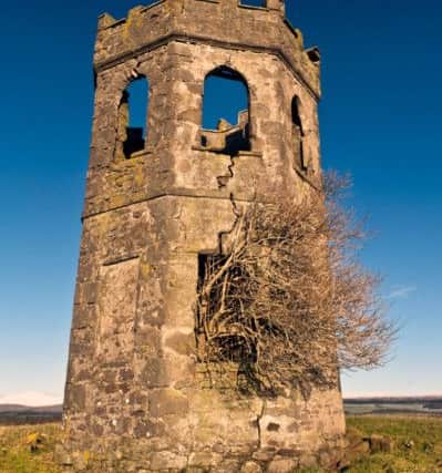
An octagon-shaped two-storey Gothic sandstone tower with a parapet and iron staircase circling the outside, it was never used as a functional building, although there was reportedly a fireplace on both floors.
Local traditions claims that Murdoch, who stayed in nearby Gartincaber House, built the tower to mark the ‘centre’ of Scotland.
Advertisement
Hide AdAdvertisement
Hide AdAnd a report in the Bridge of Allan Times in spring 2012 suggested that Murdoch ‘scandalised the neighbours by marrying his housekeeper Sarah’ and that the tower was built for her.
The tower was also used for ‘outings and picnics’, with views of Stirling Castle and, latterly, the Wallace Monument, from the parapet.
During World War II, the tower was used as a lookout post, and was painted white for the duration of the conflict.
In the following years, it was used as a trig point and again by the military during the 1950s and 1960s, when it was used to communicate with other nearby points via flashing lamps.
The tower fell into disrepair in the early 2000s, and although the Lewis Stewart Memorial Trust carved out a plan to restore the tower - even going so far as to have an engineer appraise the building in 2005 - it ultimately came to nothing due to legal issues with the landowner at the time.
And so the tower continued to deteriorate, before fierce gales in January 2012 effectively destroyed the folly beyond all recognition, leaving just a minor wall standing along with a pile of rubble.
Fast forward five years later and the casual observer might be unaware that a tower had stood there at all.
Advertisement
Hide AdAdvertisement
Hide AdAs for it marking the centrepoint of Scotland - there is some debate over the geographical location of the centrepoint - mostly down to differing methods of calculation, and whether or not Scotland’s many islands are included.
The centrepoint including islands was found to be on a hillside near Loch Garry, close to the A9 road and between Dalwhinnie and Blair Atholl.
However, another location nearby stakes a claim to be the centre of the country.
A stone set into a wall a few miles outside the village of Newtonmore marks the supposed centrepoint of Scotland.
Other locations claimed at various times to be the centre of Scotland include a point around 5km from the Schiehallion mountain, often claimed to be the centre of mainland Scotland and Harthill, on the M8 motorway between Edinburgh and Glasgow, which is described as the Heart of Scotland.