Early maps of Scotland showed hundreds of '˜fantasy' islands
This article contains affiliate links. We may earn a small commission on items purchased through this article, but that does not affect our editorial judgement.


One chart of Europe, created in 1560 by the Italian cartographer Giorgio Sideri, known as Callapoda, shows a number of mythological islands.
It also shows Scotland itself as an island “Schotia”, connected to “Anglia” (England) by a bridge.
Advertisement
Hide AdAdvertisement
Hide AdThe discovery is included in “Scotland: Mapping the Islands”, the first book to take the maps of Scotland’s islands as its central focus.
The book reproduces some of the most stunning and historically significant maps from the collections of the National Library of Scotland (NLS).
Christopher Fleet, Map Curator at the NLS and one of the three authors of the new book, said: “Callapoda’s chart of all of the islands around Scotland shows a number of mythological islands - islands that simply didn’t exist.
“It names islands that have no connection to any place we know now, and in places where we know they didn’t exist.
“That was a frequent feature of portolan charts which originated in the Mediterranean and extended out to Scotland.
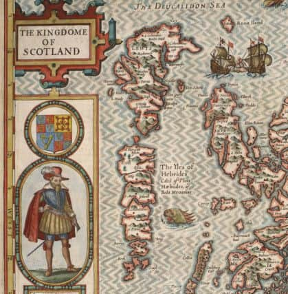
“It was an imaginary, surreal world where the maps showed non-existent features.
“At Scotland’s northeast tip is the mythical island of Till, which appears like a ‘no entry’ sign.
Advertisement
Hide AdAdvertisement
Hide Ad“On the west side there is a scattering of islands and names which don’t bare any relation to the names of the real islands then.
“Within mainland Scotland you can pick out larger towns like Bernith (Berwick), Donfres (Dumfries) and Donde (Dundee) as well as the rivers Tueda (Tweed), Fert (Forth) and Latara (Tay).
“It’s a blend of fantasy and reality which reflects geographic information from at least two centuries earlier that is just being repeated because they had no better information.”
The chart, which could be the earliest known map of Scotland, also includes a giant feature labelled Schlandia at the top, thought to represent Shetland, but no clue is given to the identity of some other islands.
In contrast to Callapoda’s chart, many genuine Scottish islands were omitted from maps of Scotland altogether until only 150 years ago.
The earliest survey of all of Scotland’s islands was carried out in the 1580s and 1590s as part of a nationwide survey by Timothy Pont. But he missed out a huge number.
Mr Fleet said: “Pont moved away from ‘fantasy islands’ to what really existed, but he missed the vast majority of the smaller islands.
Advertisement
Hide AdAdvertisement
Hide Ad‘It was a major step forward from what had gone before, but until very recently - the 19th century - there were literally hundreds of islands that would not have appeared on any maps at all.
“The surveying of them before that time was always limited by manpower and resources.
“In the Western Isles, even though local people would have known all the islands, many of those islands wouldn’t have appeared on maps.
“Some of the earliest outlines of the Western Isles and of Orkney and Shetland are barely recognisable - just a few larger islands shown on Dutch charts in the 17th century.
“It really is within the last one hundred years that many of those islands appear on maps for the first time.
“The island of Foula, which lies west of Shetland, first appeared on an Admiralty chart in 1830 but its shape is completely different from the way it appears 40 years later when it was surveyed.”
Scotland: Mapping the Islands, is a collaborative work by the three authors of the award-winning Scotland: Mapping the Nation (2011).
Advertisement
Hide AdAdvertisement
Hide AdThe book presents the rich and diverse story of Scottish islands from the earliest maps to the most up-to-date techniques of digital mapping. It showcases some 160 maps as full colour plates, each selected for the particular stories and insights they give into Scotland’s islands over time.
Mr Fleet added: “By looking at who made these maps, why they made them, and who they made them for, we hope to show how maps both reflect and drive important processes in the history and current affairs of Scotland’s islands.
“One of the stories within the book is the idea of using maps as a window in to the way people thought about Scotland and its islands at points in time.”
Co-author Professor Charles Withers, Geographer Royal for Scotland, said “Our concern is with the mapping behind the maps - that is, with the technical, political, institutional and artistic processes by which Scotland’s islands have been variously made real in map form.
“Scotland’s islands have been powerfully shaped, on paper and in the imagination, by being represented on maps. We hope that our book will give Scottish islands the attention they deserve, and properly recognise their role in shaping the geography, history, and present state of Scotland itself.”
Scotland: Mapping the Islands by Christopher Fleet, Margaret Wilkes and Charles W.J. Withers, is Published by Birlinn, in association with the National Library of Scotland, £30.00
DOWNLOAD THE SCOTSMAN APP ON ITUNES OR GOOGLE PLAY