Scotland's Weather: Warning raised to amber ahead of Arctic blast


Some parts of the UK are set to feel colder than places in the Arctic Circle as the freezing temperatures continue into the week.
Widespread snow is forecast, and the Met Office has issued weather warnings for Monday, Tuesday and Wednesday.
Advertisement
Hide AdAdvertisement
Hide AdParts of Scotland could receive up to eight inches of snow, resulting in potential travel chaos and potential for power cuts. Rural communities could be at risk of being cut off.
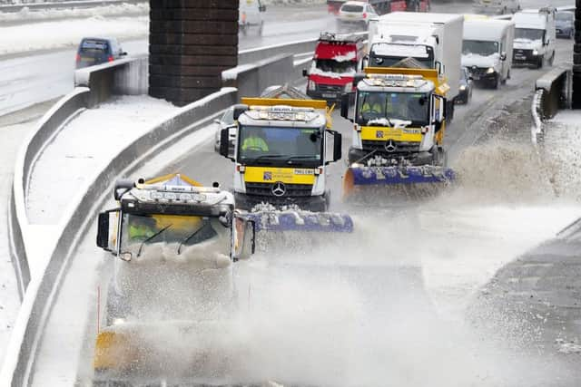
By the middle of the week, the majority of Britain is being warned of the potential for delays on the roads, trains and in the air.
The Met Office said that by the end of Wednesday, more than 20cm of snow may have accumulated in some parts of eastern England, Scotland and Northern Ireland.
Met Office meteorologist Charlie Powell said: “The UK is on track for some really cold weather this week. It’s not going to be record-breaking, but it’ll be pretty exceptional - winds are going to make it feel minus 10C (14F) to minus 15C (5F) during the day.
“We will see the first signs of that tonight in the shape of snow showers working all the way down the east coast.
“That continues into Monday, with snow showers moving across the country during the day before reaching Wales.
“Winds are then going to strengthen and we could see some easterly gales through the eastern Channel and east Anglia by the middle of the week.
“That’s going to make it feel really cold, daytime temperatures on Wednesday and Thursday will be struggling to get above freezing for most of the country.”
Advertisement
Hide AdAdvertisement
Hide AdHe added: “By Thursday evening, there are growing signs there could be some significant snowfall across southern England.
“Unusually for Britain, the snow is going to be quite dry, so it will blow around and gather in drifts and we could see some blizzard conditions.
“We don’t want to scare people, but people should make sure they are prepared for some seriously cold weather.”
Lows of -5C (23F) recorded over the weekend marked the lowest temperature in the week leading up to March 1, the first day of spring, since 1986.
The wind chill, which could see parts of the UK feeling as cold as -15C (5F), rivals the temperatures forecast for parts of northern Norway and Iceland.
The area of most concern runs in a ribbon from the north to the south east, taking in areas of greatest population in the highlands and on the east coast. This includes the cities of Aberdeen, Dundee, Perth and Edinburgh.
More widely, areas identified as being at risk from 4am until 9pm include Central, Tayside, Fife, Grampian, Highlands and Islands, south west Scotland, Lothian and Borders and parts of Strathclyde.
Warnings for Glasgow and the west coast remain at yellow for the three warning days.
Advertisement
Hide AdAdvertisement
Hide AdThe amber alert states:” Heavy snow showers are expected on Wednesday. Travel delays on roads are likely, stranding some vehicles and passengers.
“Some delays and cancellations to rail and air travel are likely. There is a good chance that some rural communities could become cut off.
“Power cuts are likely and other services, such as mobile phones, may be affected.”
In its explanation of the meaning of colour-coded warnings, the Met Office says that amber constitutes a “potential risk to life and property.”
It advises those within the warning area:”Amber means you need to be prepared to change your plans and protect you, your family and community from the impacts of the severe weather based on the forecast from the Met Office.”
The Scottish Government will activate its emergency resiliance committee, charged with keeping the country moving and the lights on.
Power companies will place team on standby to carry out repairs to the supply network.
The Met Office in Aberdeen said the country is in line for a repeat of the atrocious weather of March 2013, when much of Scotland was brought to a standstill.
Advertisement
Hide AdAdvertisement
Hide AdThe cause then - as now – is the arrival of bitterly cold air from Russia and Scandinavia picking up snow as it crosses the North Sea.
In 2013, the so-called ‘Beast from the East’ produced the coldest March since 1962, when the day-time temperature rarely got above freezing.
It’s possible we could see a repeat of last month’s whiteouts, when conditions became so bad that police warned against travel and the Scottish Government asked employers to let staff leave their work early.
School closures are also a possibility. Mid-week football fixtures could also be disrupted. There is a full card of games on Tuesday and Wednesday nights in all of Scotland’s football leagues, including St Johnstone V Rangers and Hearts V Kilmarnock in the premiership on Tuesday night followed by home ties for Celtic, Hibernian and Motherwell on Wednesday.
Simon Partridge of the Met Office said:”It’s not looking good for Scotland on Wednesday.
“It is going to be very cold and we will see a constant procession of showers of snow across eastern parts.
“Temperatures on Wednesday and Thursday may not get above freezing. With the wind chill, eastern coasts will feel like Minus 11C (12F) during the day.”