Scotland flood warnings map: all the SEPA warnings in place after Storm Dennis brings heavy rain
These are the 10 flood warnings currently in place in Scotland, according to the Scottish Environment Protection Agency (SEPA):
The River Isla at Coupar AngusYes
Upper TayYes
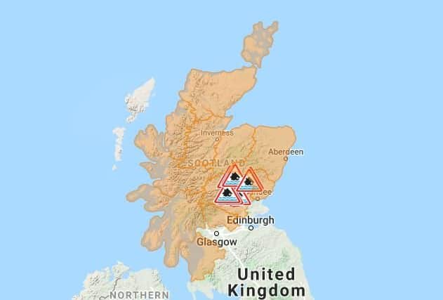

Pitlochry to BallinluigYes
Logierait to Jubilee BridgeYes
Innerpeffray to Bridge of EarnYes
Crieff to InnerpeffrayYes

Carse of Lennoch to LochlaneYes
Bridge of Ruthven to LeitfieYes
Ballinluig to LogieraitYes
Aberbothrie
SEPA said: “Remain vigilant and remember, it is your responsibility to take actions which help protect yourself and your property.
Advertisement
Hide AdAdvertisement
Hide Ad“Advice and information is available through Floodline on 0345 9881188. If you haven't already signed up to receive free flood messages, please call Floodline or register online at sepa.org.uk/floodingsignup.”
Is more rain set to hit Scotland?
The Met Office explains that, "Although the severe weather associated with Storm Dennis has passed, there is further wet and windy weather to come this week."
Chief Meteorologist Andy Page said: “Further rain will arrive on Wednesday evening and this is likely to become prolonged and possibly heavy over areas of high ground. For example, there is a chance that 60mm of rain could fall in parts of south Wales over 24 hours."
The Met Office UK outlook for Tuesday (18 Feb), explains that it will be another windy day with a mixture of sunny spells and blustery showers. Showers will be heavy at times, occasionally with hail and thunder and over hills showers will also be wintry. It will also feel chilly.
Early Tuesday evening showers will gradually become confined to the far north of Scotland. It will be colder than last night with a touch of frost.
Wednesday (19 February) will see a cold, bright start for most but early cloud and rain over Cornwall will spread eastwards. Rain will then turn heavy at times over high ground in the west later. It will also turn windier.
Rain, some of which will be heavy, will spread East with then blustery showers on Thursday (20 February). The South will see a fine start on Friday (21 February), with cloud and rain in the North reaching all areas, later clearing to sun and showers.