Vintage map lifts lid on Scotland's lost railways


Drawn up by map maker John Airey for the British Railway Clearing House, the map is colour-coded by hand to display all of Scotland’s rival rail firms.
The map shows how, in a matter of just 30 years, the railways had truly taken over as the main form of inter-city transport. From Gretna to Edinburgh, Annan to Thurso; the entire country was already connected. A footnote at the bottom reveals that Airey had already completed similar maps for the rest of the British mainland, showing all the connecting points in the UK rail network.
Advertisement
Hide AdAdvertisement
Hide AdAs David Spaven explains in his book, The Railway Atlas of Scotland, the fast expansion of the railways was as much down to resources as it was with the intention of connecting communities, “The intense rivalries between the Caledonian and North British Railways was epitomised by competition for freight traffic in the rich mineral belt stretching from West Lothian through Lanarkshire - a key source of the coal and iron ore powering the Industrial Revolution”.
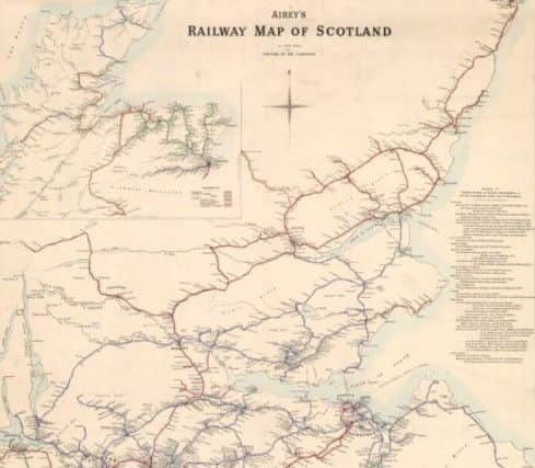
Prior to 1875, Scotland’s two railway titans, the Caledonian and North British railway companies, had been producing their own separate maps which omitted rival lines and failed to show the whole picture. The Airey map of 1875 sought to change this.
Chris Fleet, Map Curator at National Library of Scotland, explains: “The Airey map of Scotland’s railways is particularly fascinating. It was produced by the British Railway Clearing House and these maps were the first to show the country’s railway lines in an even and non-biased way. The idea was to show a non-corporate overview which is why this map is so significant.”
Although the extent of the railway network was not yet at its peak - that would happen around the turn of the 20th century - the network was more extensive than it is today.
Zooming into the map reveals that regions such as the Borders, Stirlingshire and the Grampians boasted considerably better coverage than they do today. Likewise, in the inner city areas of Glasgow and Edinburgh, there is far more interconnection.
Many of these 19th century lines were later deemed unprofitable by the Beeching reviews of the 1950s and ‘60s and were subsequently removed. Scores of stations up and down the country, many of them still extant, were also closed down.
Spearheaded by Dr Richard Beeching, the heavily-criticised reports led to the closure of over 2,000 railway stations and the loss of more than 4,500 miles of railway network and 67,000 jobs.
650 lines were ripped up in Scotland alone, including the Waverley Route from Edinburgh to Carlisle which left the Scottish Borders as the only area in the UK without a railway line. With a popualation of around 16,000, the town of Hawick earned the dubious distinction as the furthest town away from a station.
Advertisement
Hide AdAdvertisement
Hide AdToday, the routes of hundreds of these lines have been preserved and transformed into footpaths and cycleways, leaving the possibility in some cases that the railways could one day return. In the case of the newly-reopened Borders Railway, some sections already have opened, albeit with their routes much-altered.
To access a fully-zoomable version of Airey’s 1875 map, please visit the NLS Maps archives online here.