Scotland’s weather: Flood warning for east coast


Weathermen yesterday issued a yellow – “be aware” – severe weather warning for more than two inches of rain, which it said would be persistent and heavy.
A Met Office spokesman said: “The public should be aware of a significant risk of localised disruption due to surface water flooding.
“Lightning may be an additional hazard.”
Advertisement
Hide AdAdvertisement
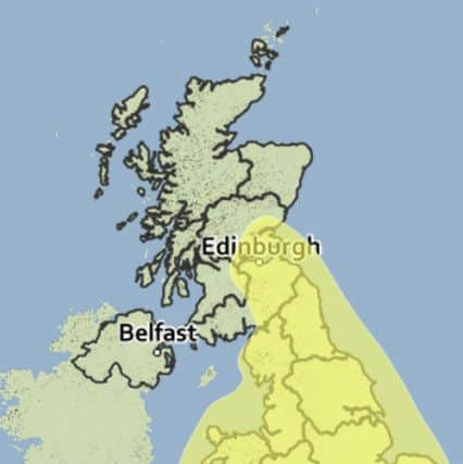
Hide AdThe alert, for the whole of tomorrow, covers an area which includes the Borders, Edinburgh, the eastern Central Belt, Fife and southern Tayside – along with the whole of England and Wales.
A similar alert covers the southern half of England and most of Wales today.
The warnings came less than a month after flash-floods hit parts of Scotland, with around 100 homes at Alyth in Perthshire being evacuated after the River Alyth burst its banks.
More than 750 homes were left without power and several motorists had to be rescued from their vehicles.
The Met Office spokesman said: “An area of low pressure pushing into the southern UK early on Thursday will continue slowly northwards, to be centred near or just east of Scotland by Friday afternoon.
“With very warm air entrained into the system, further outbreaks of locally heavy rainfall are likely during Friday, particularly during the early hours and morning, with locally in excess of 50mm [2in] by the end of Friday.
“The rain may be torrential at times and there is also a risk of hail.
Advertisement
Hide AdAdvertisement
Hide Ad“This rain will tend to ease through the day, probably becoming confined to eastern UK by the end of Friday.
“The development and subsequent track of this system is very complex.
“In this type of situation, whilst we can be confident that many will see some heavy rain, details of where thunder, lightning and the highest rainfall totals – and therefore the highest risk of disruption – is rather uncertain.
“However, we also expect most parts will see some dry weather between the spells of heavy rain.”
Weathermen said the bad weather was coming from southern Europe.
The Met Office added: “We are continuing to monitor the evolving situation over the Bay of Biscay and are now beginning to see some thunderstorms developing over France.
“Over the next 24 hours, we expect heavy rain and thunderstorms to increase in this area.
“This is due to increasingly warm air being drawn into the developing low pressure system.
Advertisement
Hide AdAdvertisement
Hide Ad“This area of more widespread heavy, thundery rain is then expected to move northwards crossing the English Channel and into southern parts of England during the early hours of Thursday.”
Paul Watters, head of roads policy for the Automobile Association, said: “Flash flooding in the summer can be hit and miss, but potentially dangerous for anyone caught up in it.”