9 Scottish towns, villages and beaches under attack from the sea


Around 2,300 miles of Scotland's "soft coastline" is at risk of erosion with major work carried out to identify where the changes have been worst - and where is at most risk in the future.
The Dynamic Coast project, run in conjunction with Scotland's Centre of Expertise For Waters (Crew) has charted how Scotland's coast has changed over the past 100 years or so.
Advertisement
Hide AdAdvertisement
Hide AdIt found that around 537 miles of soft coastline has moved position since the 1970s. Some has advanced closer to the sea as the oceans natural process of dumping sediment continues but 12 per cent of this coastline has eroded away with properties, golf course, airports and railway lines all at risk from the shifting picture.
Where changes to the coast have occurred, they have occurred faster than before. Here we look at nine places in Scotland where erosion is taking its toll - and how the future looks for these town, villages and beaches as decades of future rises in sea levels are predicted.

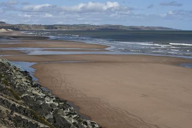
Around 300 metres of lasnd to the east of Dunbar by Torness had been claimed by the sea over the past 100 years
Dunbar East Beach was a sandy beach as recently as 2013, however, following heavy storms the following year the beach was almost entirely eroded.
Plans are afoot to feed the beach with sediment to promote its natural regeneration with a seawall defence also being considered.
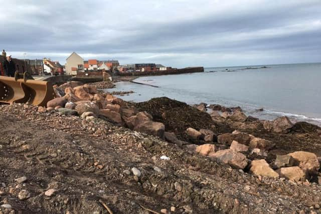
Immediately to the west of the harbour, the coastline has eroded between 16 metres and 48 metres between 1982 and 2011. Further erosion
expected by 2050 with several protected natural areas and Battle of Dunbar battlefield potentially at risk by the impact of the tides.
North Berwick has dealt with the impact of the mighty North Sea tides relatively well over the years but erosion is set to afflict the coast to the west and the south of the harbour by 2050.
Advertisement
Hide AdAdvertisement
Hide AdThe changes could potentially impact on 34 buildings and residences as well as a sigicant portion of of Victoria Road and Melbourne Road, the only access routes to the harbour.
3. St Andrews
Part of the historic links course at St Andrews is also at risk of erosion.
There are two points in the dune system at the beach that have come under particular pressure from the tide - to the north of the Eden Estuary and the saltmash below the seawall surrounding the Eden Course.
If the past rates of erosion continue then tides are expected move up to 40 m inland by 2050.
Various coastal protection areas have been taken over the last decade to protect the historic town's assets, including the building of a new 300-metre dune and replanting saltmarsh.
The work continues.
4. Tentsmuir
Parts of this beach between the River Tay and the Eden Estuary have suffered the fastest rate of erosion in Scotland with the stretch of coast at Reres Wood moving inland some 500 metres in less than 100 years.
In turn, the dunes at Tentsmuir Point to the north of the beach have moved closer to the sea given the natural process of accretion, when the sea dumps new sediment onto the shore. Here, the dunes have moved towards the sea at a rate of around six metres a year.
Further deep changes at the beach, which sits across the Tay from Dundee, are expected. It is estimated that the tides at Reres Wood will have moved in another 100 come 2050.
5. Montrose
Advertisement
Hide AdAdvertisement
Hide AdThe changes at Montrose beach are clear and devastating, with the once lush dune system pushed back by the tides and the hardrock defences scarring what was once Scotland's finest beaches. Parts of the links golf course are falling away.
Research has found that the section of beach at Kinnaber Links and the golf course frontage eroded up to 20 metres between 1903 and 1984 with changes more drastic since then. Around 40 to 60 metres of beach has eroded since then.
Industrial development at Montrose Harbour has led to the coastline being hardened and defences extended. Part of the shoreline at Trail Drive has been cut back aggressively, with around 50 metres lost between 1982 and 2014.
It is unclear to what extent these shifts in the shoreline are due to natural changes in the tide's work or if human intervention, including harbour dredging and the construction of coastal defences, has been at play, according to the Crew report.
"Whilst there are faster areas of retreat elsewhere in Scotland, few exist along such a lengthy stretch of soft and susceptible shore as along the Montrose golf course fronting the northern part of the town itself," the report said.
In some areas, further erosion of up to 80 metres is expected by 2050.
"Crucially, the main areas of golf course fronting the suburban areas are low lying and protected from erosion and inundation by an ever-narrowing cordon of high dunes along the Montrose Bay frontage," the report said.
6. Burghead and RAF Kinloss
Most of the beach at Burghhead has retreated over time with erosion at its worst along the shoreline in front of RAF Kinloss. There, around 15 to 25 metres of beach has gone between 1969 and 2011.
Advertisement
Hide AdAdvertisement
Hide AdIf erosion rates continue as they are, it is expected that the high spring tides will come within 40 metres of one of the service roads at the base.
Meanwhile, some access roads at Findhorn Sands Caravan Park come within 10 metres of the expected position of the spring high tides by 2050, according to the report.
7. Clachtoll Beach, Sutherland
This favourite Highland beach for camping is also suffering under the weight of the tides.
The northern beach is whipped by wind and waves with the elements taking out some of the machir from the low-lying dunes. Cars and caravans coming over the machir also left their mark, although longstanding restrictions on vehicles have helped to steady the picture.
Despite the action, some 14 m of erosion has been recorded between 1970 and 2014.
The entire shoreface at Clachtoll is set to recededby a further 22 metres by 2050 with the wider impact likely to hit two buildings at the south of the beach.
There are concerns that any further erosion will damage the dunes and weaken the the natural wind barrier, blowing out sands and impacting its value as a tourist asset.
"The importance to the local economy of the popular campsite as an asset to the rear of the beach is a both a consideration and a cause for future concern," the report said,
8. Kylerhea, Isle of Skye
Advertisement
Hide AdAdvertisement
Hide AdThe beach at Kylerhea has eroded up to 17 metres between 1963 and 2012 with the rate surprising researchers given the sheltered nature of the coast.
Land surrounding the beach is used for pasture and grazing, with several homes and crofts overlooking the sea to the south.
It is expected that a further 16 metres of erosion will have hit by 2050 with the shift lilkely to impact directly on five properties along the coast.
" All the adjacent coastal land is given to pasture and since there is a limited amount of suitable pasture nearby, the loss of such land is likely to be of concern for the future viability of the crofts here," the report said.
9. Laggan Bay, Islay
The entire bay lost 74 metres of land to the changing tides between 1979 and 2014, the most affected stretch being close to the runways at Islay Airport.
The end of the main runway lies 80 m away from the point where the high spring tides reach but it is estimated that a further 88 m of land will be directly impacted by erosion by 2050.
It has been suggested that the airport could change the layout of its runways to protect them from future changes in coastline.