Video: Evidence of Roman roads in Scotland


The Roman Empire was an economic superpower of its day, with vast armies laying capturing 5 million square kilometres of territory spanning three continents.
At the Northwest of the empire’s reach, Scotland put up a fight that spanned several campaigns putting the glory of the empire under duress.
Advertisement
Hide AdMarkers of Roman occupation can be found between Carlisle and Falkirk, but none have weathered the storm quite like the roads.
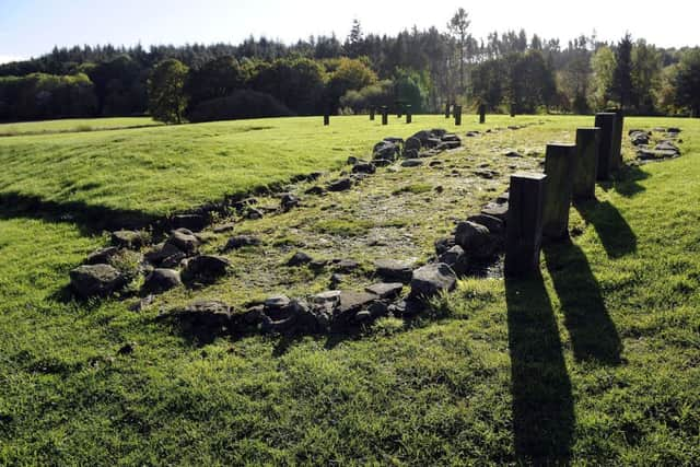
The most prominent Roman route into Scotland is Dere Street, today mirrored in part by the A1 and other main roads.
Dere Street was one of two key entry points for armies travelling up to face the highlanders of the North. It’s believed occupying forces would have built the original road AD 79-81, and was repurposed during the construction of Antonine’s wall some 60 years later.
Roman roads were typically 15ft wide and where building on sodden ground - which was often the case in Scotland - rolls of brushwood would be laid on the wet earth, packed down by overturned peat and stones could then be safely laid on top.
To keep the path clear, ditches were dug alongside - many still visible at historical sites today.
Dere Street Roman Road stretches from York to what is now Falkirk, with junctions like the suspected route to Berwick.
Advertisement
Hide AdAyrshire is rich with remnants of a road network and while very few sites have been confirmed as being Roman, many more are widely believed to connect to the same network.
A route from Fairlie, near Largs, can be traced through to an ancient fort surrounded by low hills in Bishipton and a second fort on Loudon Hill connects to Castledykes and possibly beyond to Strathaven.
Advertisement
Hide AdWhile completely unproven, evidence has arisen of Roman roads potentially awaiting discovery in Nith Valley, Irvine Valley, Girvan, Ayr, Dalmellington and Kirkudbright to name but a few.
Tested by their lack of advancement into the Highlands and with their armies under pressure in the Balklans, the invaders gave up on completing their network.
Troops were reassigned to fight in Eastern Europe and the remaining soldiers retreated back to the relative safety of the Solway line forts at Gatehouse and Newton Stewart.