Six great Scottish islands you can only reach by sailboat


But what about those that are not so easily accessible, and you need to make your own way by boat.
Here are some of the best such must-see islands.
ST KILDA
The remotest outpost in the UK, its largest island Hirta was occupied until 1930 when the last islanders left after they asked to be evacuated because their way of life was no longer sustainable.
Advertisement
Hide AdThe island group is situated 40 miles west of the Outer Hebrides.
On the islands there are still some of the Soay sheep left. Mainly the islands are inhabited by puffins, northern gannets, leach petrels and many more birds.
St Kilda was bequeathed to the National Trust for Scotland in 1957 and allocated World Heritage status by UNESCO in 1986 in recognition of its natural heritage, exceptional natural beauty and for the significant natural habitats that it supports.
In July 2004 this was extended to include the surrounding marine environment and in 2005, recognition was also given to St Kilda’s unique cultural landscape.

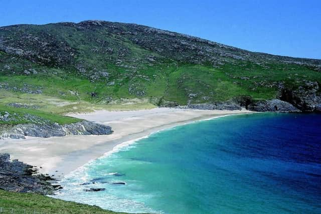
THE MONACHS
The islands are covered by beautiful white sandy beaches and clear, blue seas. No one has lived here since 1948 and visitors are few and far between.
Now a national nature reserve, you need permission from Scottish Natural Heritage to land.
Advertisement
Hide AdSitting just to the west of North Uist, the group of five islands also known as Heisker were once connected to North Uist by a sandbank.
It is believed that that a huge storm swept the sandbank away, leaving the low lying isles to the mercy of the Atlantic.
Advertisement
Hide AdThe Monachs are made up of Deasker Island, Stockay Island, Shillay Island, Ceann Iar Island, Shivinish Island and Ceann Ear Island, which was once home to a nunnery with a lighthouse later constructed and operated by monks.
The nuns were said to be so strong that they were able to row boats across the Sound of Monach to Uist to return with peat for fuel. In 1764 the population was recorded as 70. Up to 10,000 seals now call The Monachs home with over 200 different types of flowers and grasses to be found.
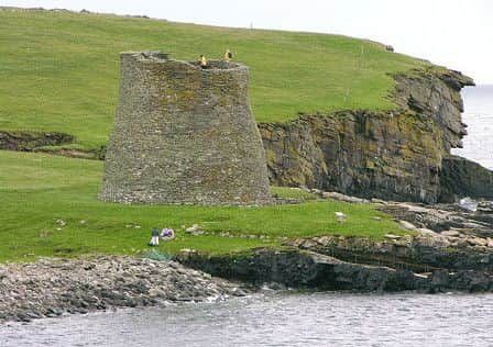
MOUSA
The tiny Shetland island is most famous for being home to Mousa Broch, the best preserved Iron Age tower in existence in the world.
Visitors can still climb the staircase of the 2000 year-old building, providing great views of Mainland Shetland.
The broch features in old Norse Sagas as a place of captivity and hiding. In more recent times it was used as the secret store for smugglers.
Mossy Island in Old Norse, it is today an RSPB Nature Reserve with important breeding colonies of seals and seabirds including the storm petrel, hundreds of which have made their home within the broch walls.
Advertisement
Hide AdVisitors can also observe a range of plant and wildlife including some quite rare species. Whales and otters also make appearances.
Situated at 60º North, it has an approximate latitude with Oslo and Helsinki. The island is 1½ miles long and about 1 mile at its widest and supported 11 households in 1794 but became uninhabited when the last family left in 1853.
Advertisement
Hide AdThe Orkneyinga Saga tells how in 1153AD, Erland the Young abducted Margaret, widowed mother of an Orkney Earl, and took refuge in Mousa. Earl Harold followed and besieged the broch but found it “an unhandy place to attack”.
MINGULAY
The largest of the Bishop’s Isles, it is a remote isle where a tiny community survived until the island was abandoned in 1912.
This island lies 12 miles south of Barra and is now owned by the National Trust of Scotland, Mingulay can be accessed in the right conditions by boat from neighbouring islands, including Barra.
While no longer a permanent home to Hebridean islanders, Mingulay still provides a rich habitat for birdlife, with the towering 250 metre Carnan cliffs providing protected breeding grounds for fulmars, guillemots, kittiwakes, oystercatchers, puffins, razor bills and terns.
PABBAY
Pabbay is also one of the Barra Isles at the southern tip of the Outer Hebrides of Scotland.
The name comes from Papey, which is Norse for “island of the papar” - monks.
Advertisement
Hide AdAt only 250 hectares (0.97 sq mi), it never had a large population, and, after all the able-bodied men were killed in a storm while out on a fishing trip on 1 May 1897, it was abandoned in the early twentieth century.
The National Trust for Scotland has owned the island since 2000.
Advertisement
Hide AdPabbay is home in summer to many ground-nesting birds due to the absence of predators.
The island was the site of a Celtic hermitage, and a Pictish carved stone dates from that period. Remains of an Iron Age settlement can also been seen on Pabbay.
Composed of Lewisian gneiss, it is said to be one of the finest climbing venues in the UK.
GLUNIMORE ISLAND
The island is just 200 metres long and rises to a height of 27 metres (89 ft).
There is a cave on the shoreline at the north. A drying reef surrounds the island to the north and east. More of these dangerous reefs litter the sound between Glunimore, Sanda and Sheep Island.
Glunimore and neighbouring Sheep Island are the most important breeding grounds of puffins in the Clyde and the birds are now returning from here to Ailsa Craig another traditional breeding ground. Guillemots and razorbills also nest here.