The Shetland man who mapped Jamaica


But an exhibition in his home island is putting that right by exploring his life and work – including a major controversy which ended up in the highest courts of the land.
Despite his Caribbean creation receiving the highest of praise from the Jamaican House of Assembly, who had employed him, a later effort of the north-east of Scotland was deemed poor and inaccurate.
Advertisement
Hide AdIndeed, he was taken to the Court of Session by farmers who had commissioned him to do the work in a case that continued until his death in 1829.
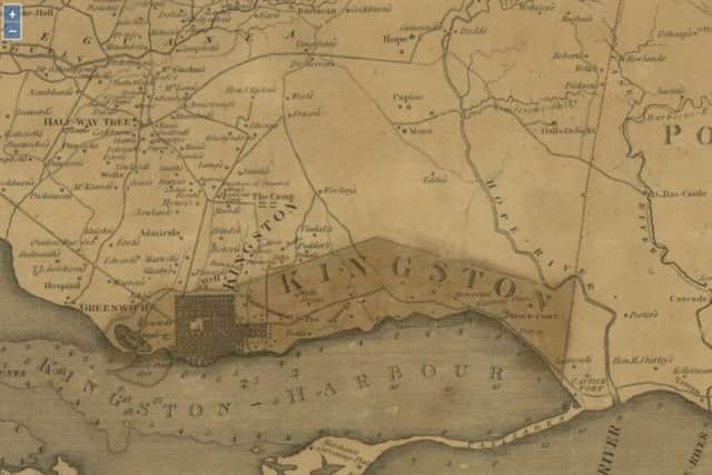
The maps created by the Shetlander, but never before seen on the islands, have been loaned by the National Library of Scotland.
The exhibition James Robertson: The Shetlander who Mapped Jamaica (1753 – 1829) has just opened at the Shetland Museum and Archives in Lerwick and will run to 22 November.
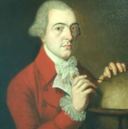
Assistant archivist Joanne Wishart has been researching Robertson’s life using sources in the UK and Jamaica.
She said: “My reseach has brought him to life.
“But, what are we to make of the island boy who soug ht his fortune in the Caribbean, lived the high life off his profits in London but at the time of his death was embroiled in an acrimonious dispute which questioned both his honesty and his professional skill.
“There seems to be no question that the Jamaica map was accurate and there were plenty of surveyors there at the time who could have queried it.
Advertisement
Hide Ad“So what happened in Aberdeen? Well, he was much older, approaching 60 when he took the job on, and nearly 70 when it was published. Had he just run out of steam? Or was he trying to
deliberately deceive the Aberdeen land owners?
Or was it the case that the landowners built a case against him to get out of having to pay him any money after the incredible delay in producing the map.”
Advertisement
Hide AdShe added: “To an untrained eye the map certainly looks impressive. So was he a con man? Maybe should we believe his own hype – that he was indeed the best mapmaker in Europe?
He certainly had been a brilliant mapmaker in his day but there may always be doubts about how much of the Aberdeenshire map is his own work. One this is for sure – he was clever and persuasive.”
The archivist said it was up to the general public viewing the exhibition to make up their own minds about Robertson, who was educated at Aberdeen Grammar School and graduated as a surveyor at the city Marshall College.
There is no doubt that, from 1796-1804, he surveyed the first detailed maps of Jamaica and they were remarkably accurate, even by today’s standards - and also an excellent insight into the island, then an important British colony and sugar exporter.
Robertson, the son of a klondyke merchant who brought luxury goods to Shetland for the few rich islanders, later returned to Britain, where he compiled a detailed map of the north-eastern counties of Scotland in the 1820s.
The exhibition features unique artefacts illustrating the practical surveying equipment that Robertson would have used, correspondence with him, and original documents relating to his map of north-east Scotland.
Advertisement
Hide AdThis shows a rural landscape undergoing profound changes and represents the most detailed mapping of the area before the Ordnance Survey work from the 1860s.
Chris Fleet, Map Curator at the National Library of Scotland said: “Robertson’s maps of Jamaica allow us to visualise this British colony at the height of the sugar industry, and Robertson’s cartography was an important means for maintaining order and control of territory.
Advertisement
Hide Ad“There were also important links with Scotland too, with many of the sugar estates owned by Scots, whose names and plantations are clearly shown on Robertson’s maps.”
Map-making in Robertson’s time brought together a range of skills - in mathematics and geometry, in practical measurement in the field, and in the artistic ability to represent landscape features with precision and consistency.
Mr Fleet added: “This exhibition allows us to trace something of Robertson’s training and experience in these areas, and the difficulties he faced in gaining funding for his work.
“Map-making was rarely a lucrative profession, and although Robertson was very well paid for his work in Jamaica, he struggled to find similar success back in Scotland.”
Items for the exhibition are being loaned also from Aberdeen City and Aberdeenshire Archives, the Royal Scottish Geographical Society and Aberdeen University, Special Collections.
A number of events will accompany the exhibition.
Local primary school pupils will have the opportunity to learn more about map making by taking part in workshops developed and delivered by National Library of Scotland. There will also be family workshops based on map making, as well as art classes and reminiscence sessions.