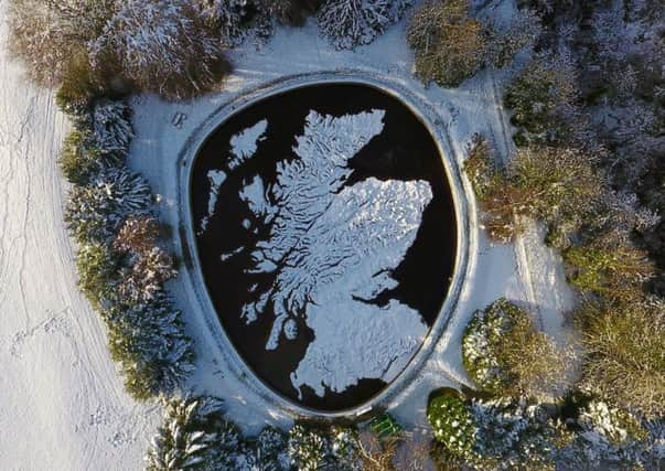
Giant map that hails Scotland's links to Poland unveiled


Culture Secretary Fiona Hyslop officially helped to celebrate the new era for the Great Polish Map in the grounds of the Barony Castle Hotel, Eddleston, in the Scottish Borders, yesterday.
The map was first devised by the owner, Jan Tomasik, in the 1970s in recognition of Scottish hospitality to Polish soldiers during World War Two.
Advertisement
Hide AdThe hotel was requisitioned during the war and became the main Polish Forces’ staff training college.
Mr Tomasik developed his concept for the map with the help of his former commander, Gen Stanislaw Maczek, who also settled in Scotland.
The map sits in an oval pool about 160ft (50m) wide and 5ft (1.5m) deep with water recreating rivers, lochs and seas.
It became fully overgrown in time but a group of volunteers set up Mapa Scotland, a charitable trust, to take the restoration forward.
Keith Burns, an engineer who attended a conference at the hotel in 1996, set up Mapa Scotland after stumbling across the map when walking in the grounds.
He almost fell into a hole in the ground that was covered by the undergrowth.
Advertisement
Hide AdMr Burns earlier said: “The first clue was when I saw a shape which looked like the Mull of Galloway. I thought I must be imagining it.
“I decided I had to look further and found the Isle of Arran.
Advertisement
Hide Ad“The whole pit area was a jungle. But I managed to walk over Ben Nevis, Rannoch Moor and reached Cape Wrath – I walked the whole of Scotland. But no-one at the hotel reception desk could tell me anything about it.”
He set up Mapa Scotland in 2010.
Mr Burns added: “It took us ten years, it was hard work and the average age of the volunteers was 68. The important thing now is that it should become a historic monument to remind young people about the links between our two countries.”
Mr Burns also succeeded in getting category B listed monument status for the map from Historic Environment Scotland.
Jan Tomasik, served with the 1st Polish Armoured Division under the command of General Stanislaw Maczek.
He was one of around 17,000 Polish troops who arrived in Scotland in 1940 to defend the east coast of Scotland, which was under threat of invasion from the Germans following Hitler’s occupation of Norway.
After the war, Tomasik stayed in Scotland and married Catherine Kimlin, a Scottish nurse, and became a hotelier.
Advertisement
Hide AdIn 1975 he recruited a team of Polish geography students to build his dream map under the guidance of Dr Kazimierz Trafas, a distinguished cartographer and a lecturer at the Jagiellonian University in Kraków, with work continuing until 1979.
