Data Capital: conservationists keep a weather eye on wild predictions
Soon, those sounds could be replaced by silence. Capercaillie numbers have plunged from an estimated 20,000 in the 1970s to 500 today, with around 85 per cent of the remaining birds living in the Cairngorms national park, including in Strathspey and on Royal Deeside.
The world’s largest grouse species was hunted to extinction in Scotland in 1785 before a series of attempts led to its first successful reintroduction from Sweden in 1837. Now, conservationists are racing to stop the bird from dying out for a second time.
Advertisement
Hide AdAdvertisement
Hide AdA new campaign – imaginatively entitled “Lek it be” – is encouraging members of the public not to go looking for capercaillies during their breeding season, so they don’t get disturbed and abandon their chicks.
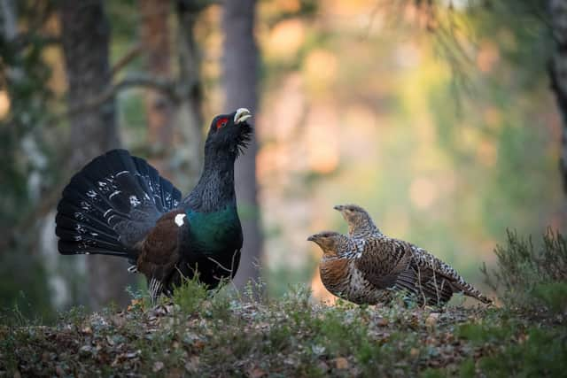

As well as disturbance from people and their dogs, the adult birds are also under threat from flying into deer fences, while the chicks are an easy meal for pine martens and other predators.
One of the other major threats to the species is climate change. The Royal Society for the Protection of Birds (RSPB) is using information from theMet Office’s new climate change data portal – launched at the end of June – to examine how changes in the weather are affecting capercaillie.
“Our conservation science team has used the data to indicate a strong link between capercaillie breeding success and June rainfall, as heavy downpours result in chicks being chilled and also a reduction in the abundance of insects for food,” explains Beth Chamberlain, senior policy officer for climate change adaptation at the RSPB.
“The Met Office data has been key in understanding those relationships and also predicting what might happen in the future with climate change affecting rainfall patterns.”
As well as looking at the effect that climate change could have on individual species, the RSPB is also using the data portal to help update management plans for its nature reserves. Analysing the risk of threats such as flooding will help reserve managers take steps to alleviate potential problems by planting trees or seeding reedbeds.
On a larger scale, the charity is also examining how climate change could affect wider habitats on a landscape scale. A key consideration is how higher annual mean temperatures could affect blanket bogs, which are found across the peatlands in the North of Scotland, Northern Isles, and Western Isles.
Blanket bogs and peatlands more generally are important natural stores of carbon, and so damage to peat could lead to more carbon dioxide being released into the atmosphere. Bogs also soak up excess rainwater, which helps to reduce flooding.
Advertisement
Hide AdAdvertisement
Hide Ad“Increased mean temperatures could lead to a longer growing season, for example, so bracken could potentially become more invasive in areas where blanket bogs are degraded,” says Chamberlain. “We might also see droughts, which could affect vegetation in blanket bogs, and we could see wetter winters, which means blanket bogs could become less stable.”
The Met Office’s climate data portal was created in partnership with Esri UK, a technology company with a major presence in Edinburgh. Esri has worked with the Met Office for more than 20 years, with the company’s tools allowing users to view the data using maps.
“Over the past two years, the Met Office has wanted to make its data more available to more people,” explains Charles Kennelly, Esri’s group chief technology officer. “Meteorological and climate data is often quite complex and only accessible to academics with the right tools.
“By presenting that information in the format of a map, you can change how people interact with it – from ‘There’s a higher flood risk in the UK’, to ‘My house is in danger’.
“We work with businesses, schools, local authorities – all sorts of customers – who use our technology. The climate data portal is one of my favourite examples, because the Met Office has done a great job of presenting understandable data in an easy-to-consume way.”
Network Rail is using the data from the portal to explore how higher temperatures could affect train lines, while water companies are using it to prepare for higher rainfall.
Kennelly says that looking at the data on maps allows emergency planners to not only look at the effect of a storm on, for example, a hospital, but also its effect on that hospital’s connection to the electricity grid.
Professor Jason Lowe, principal fellow for applied and climate science at the Met Office, says: “This portal lets you think locally. Itl allows users to think in more detail, not about individual climate hazards, but about multiple climate hazards.
Advertisement
Hide AdAdvertisement
Hide Ad“For example, in Scotland that balance of hazards might be different to other parts of the UK. For instance, if you’re on the coast and are servicing oil and gas rigs, you can look at sea level rises.
“If you’re in the Highlands and you’re thinking about tourism, you can think about extreme temperatures. If you’re in a city, you can think about extreme rainfall.”
Other species being helped by fresh data
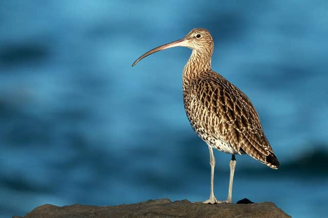
Curlew
Curlew might be a familiar sight on many Scottish beaches, but Europe’s largest wading bird is under threat and was added to the UK’s “red list” in 2015, making it a conservation priority.
While its long legs and curved beak allow it to hunt for food buried in coastal mudflats, the birds fly to moors and other upland areas during the spring to breed.
Rising temperatures caused by climate change mean the species need to head further north to achieve this.
The Met Office’s data is helping the RSPB to identify suitable cooler areas where the charity can support breeding pairs.
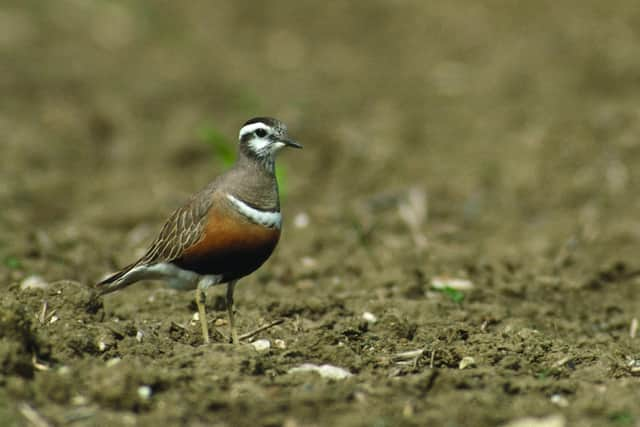
Dotterel
The dotterel is a real mountain-top specialist. Although they are often spotted on the coast during their spring and autumn migrations to and from Southern Europe and North Africa, the birds breed high up in the Cairngorms and north-west Highlands during the summer.
The fact that they need cool mountain habitats to breed means they’re susceptible to climate change, with warmer summers putting them at risk.
Advertisement
Hide AdAdvertisement
Hide AdThe RSPB is using climate change data from the Met Office to predict which sites may remain cool enough for dotterels and therefore require habitat protection.
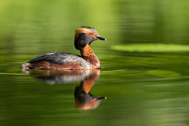
Slavonian Grebe
Arguably one of Scotland’s cutest birds with its piercing red eye and golden ear tufts, the Slavonian grebe breeds on only a few lochs in the Highlands during the summer, before moulting into its duller black-and-white winter plumage and heading for the coast during winter.
Only 28 breeding pairs are left in the UK, placing it firmly on the “red list” of birds that get priority for conservation.
Data from the Met Office is helping the RSPB to understand how Slavonian grebes might be affected by climate change, and what steps might be needed to protect these precious birds.