Storm Eunice: Four people killed as winds reach 122mph - with another storm following on Sunday

A woman in her 30s died after a tree fell on a car in north London, while a man in his 50s was killed in Netherton, Merseyside, when debris struck the windscreen of a vehicle he was travelling in.
A man in his 20s died in Alton, Hampshire, after a Mercedes-Benz Sprinter pick-up collided with a tree in Old Odiham Road just before midday. In County Wexford in the south east of Ireland, a man was killed by a falling tree.
Advertisement
Hide AdAdvertisement
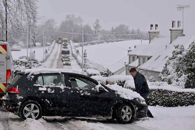
Hide AdHeavy snow closed several major roads in Scotland, while more than 100 schools were shut or closed early and a weather warning remains in force until 6pm on Friday.

It will be followed by an alert for ice over most of the country from 6pm to 9am on Saturday.
Ten coastal flood warnings were issued for Dumfries and Galloway and Ayr-Troon by the Scottish Environment Protection Agency.
A further severe weather warning has been issued by the Met Office for Sunday and Monday, which, if named as a storm, would make it the third in five days after Storm Dudley on Wednesday.
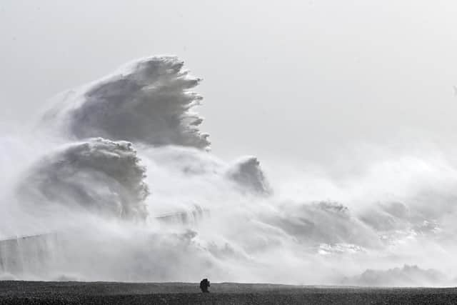
Storm Eunice affected southern England the worst, with a rare double red warning – the highest level – for parts of the south west and south Wales, and London and the south east, and an amber morning for all but the north of England.
Described as one of the worst storms to hit the UK in a generation, Eunice’s gusts were provisionally recorded as reaching 122mph at the Needles on the west coast of the Isle of Wight, off the south coast.
If verified, it would be the highest recorded wind speed in England.

London Ambulance Service said two people were taken to hospital after being struck by falling debris and a tree in separate incidents in Waterloo and Streatham in south London, an hour apart.

Advertisement
Hide AdAdvertisement
Hide AdMain roads closed for a time by snow included the M90 south of Perth and the A7 between Hawick and Selkirk in the Borders.
The A93 remains shut between Braemar and Glenshee in Aberdeenshire, along with the A939 between Cock Bridge in Aberdeenshire and Tomintoul in Moray.
CalMac suspended several of its west coast sailings because of the sea conditions, including to Arran, Coll, Tiree and Colonsay, and warned of further disruption continuing into next week.
A spokeswoman said: “With more poor weather forecast for the coming days, we are asking customers planning to travel with us to check their journey before setting off.
“It is likely that some sailings will be cancelled, sometimes at short notice, if conditions deteriorate.
"This will only happen as a last resort if our experienced masters agree that sailing will put passengers and crew at risk.”
Buildings damaged by the winds included the O2 Arena in London.
Western Power Distribution said that, as of 1pm on Friday, more than 140,000 homes were without power, the vast majority of which were in the south west of England.
Advertisement
Hide AdAdvertisement
Hide AdWind speeds forced both the M4 Prince of Wales Bridge and M48 Severn Bridge into Wales to close to traffic for what is believed to be the first time in history, while the Humber Bridge linking Yorkshire and Lincolnshire closed from 1:30pm.
All four daytime cross-Border train operators urged passengers not to travel because of likely disruption, with Avanti West Coast and east coast operator LNER among those cancelling services.
However, Caledonian Sleeper was still planning to run its overnight trains between Scotland and London on Friday night.
CrossCountry welcomed a decision by the Rail, Maritime and Transport union to call off planned strikes on Saturday as well as the following Saturday, March 5 after the union withdrew its dispute over train staff.
The Met Office yellow warning for ice involves “a mixture of wintry showers and clear spells likely to lead to a cold night with some icy stretches developing on untreated surfaces”.
A spokesperson said: “Brisk north westerly winds will continue to bring increasingly wintry showers overnight on Friday and at first on Saturday.
"Some snow is likely to accumulate over around 200m, with another 10-15cm over the mountains, but the wintry mix is more likely to bring a risk of icy roads and pavements as surfaces left wet by showers or hail/snow/slush then fall below freezing.”
The agency’s yellow warning for strong winds for 24 hours from noon on Sunday includes gusts which could reach 80mph.
Advertisement
Hide AdAdvertisement
Hide AdIt will cover most of Scotland apart from the extreme north until noon on Monday.
The warning also covers parts of Northern Ireland, north west England and north Wales.
A Met Office spokesperson said: “Another spell of very strong winds is expected in parts of Northern Ireland, Scotland and also some Irish Sea coasts.
"Winds could gust to 50-60mph inland and between 70 and 80mph for a time on the mountains and exposed coasts, with large waves expected as well.
"The strong winds will be accompanied by heavy, frequent and increasingly wintry showers, with blizzard conditions expected in the mountains, before conditions ease later on Monday.”
A separate yellow warning for rain has been issued for midnight to 6pm on Sunday for northern England, south from the Border as far as Derbyshire.
The Met Office said: “A band of heavy rain will affect parts of north west England on Sunday and become slow moving for a time, with some very heavy rain, especially over high ground.
"The duration and intensity of the rainfall could bring widespread totals of 20 to 40mm, but some exposed sites may see 75 to 100mm.
“This will fall on to already-saturated ground.
"The rain should clear south by Sunday evening.”
Advertisement
Hide AdAdvertisement
Hide AdMet Office chief meteorologist Steve Ramsdale said: “Winds will decrease from their exceptionally high levels on Friday, but there’s a continued wet and windy theme for many through the weekend.
“The south will see wet and windy conditions on Saturday, before areas to the north and west, including Northern Ireland, see some more potentially disruptive conditions on Sunday.”
A message from the Editor:
Thank you for reading this article. We're more reliant on your support than ever as the shift in consumer habits brought about by coronavirus impacts our advertisers.
If you haven't already, please consider supporting our trusted, fact-checked journalism by taking out a digital subscription.
Comments
Want to join the conversation? Please or to comment on this article.